
$6,500 / Month
4218 Rickeys Way
Palo Alto, CA 94306
2 Weeks Ago
Favorites
4218 Rickeys Way

Favorites
Check Back Soon for Upcoming Availability
| Beds | Baths | Average SF |
|---|---|---|
| 3 Bedrooms 3 Bedrooms 3 Br | 2.5 Baths 2.5 Baths 2.5 Ba | — |
About This Property
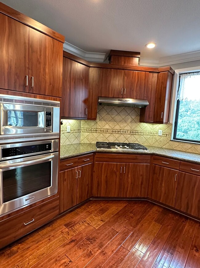
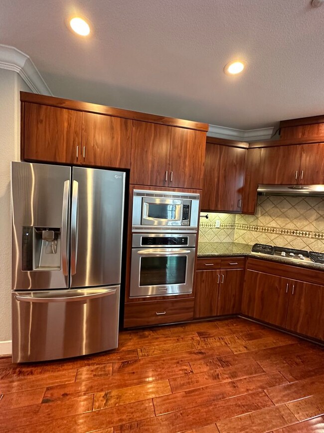
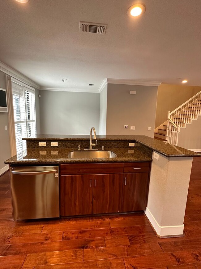
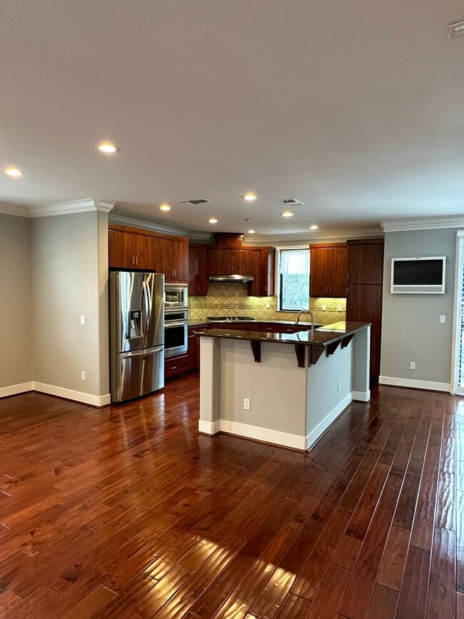
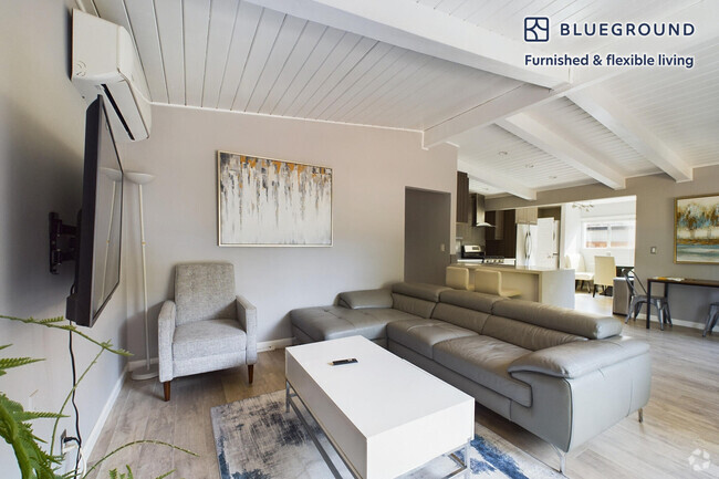
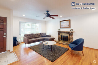
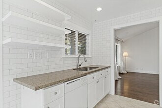
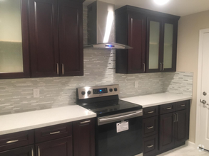
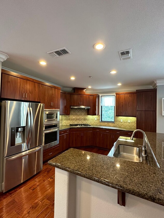
Gorgeous 2400sf townhouse, with beautiful hardwood floors, light and open! Spacious living room with vaulted ceiling, open to kitchen/dining area 1/2 flight up. Fabulous chef's kitchen has plenty of storage, granite counter tops, stainless appliances. Dining area. Half bath on this floor. Upstairs: 3 bedrooms. Two guest/children's rooms have large closets with California Closet built in storage, wall mounted TV in place. Primary suite has two walk in closets (also fully finished with California Closet units), AMAZING ensuite bath with tub and shower and of course, double sink. Wide plantation shutters give all the windows privacy. Two car private garage with car charger, LOADS of storage! Rickeys Way complex has a large swimming pool for summer fun and a community garden to give you fresh produce to bring to your beautiful kitchen! Will consider a small, well behaved dog, with additional deposit. Schools: (Tenants to verify availability) K-5: Briones Elementary. rated 8/10 .5 miles away 6-8: Fletcher Middle School rated 8/10 .6 miles away High School: Gunn. rated 9/10 .9 miles away Please contact Teri Berwick (BRE 01705674) at for an appointment to view. Professionally managed by Summerhill Property Management, Inc. (BRE 01523660)
4218 Rickeys Way is a house located in Santa Clara County and the 94306 ZIP Code. This area is served by the Palo Alto Unified attendance zone.
Property Address:
4218 Rickeys Way,
Palo Alto,
CA
94306
Palo Alto is known as the birthplace of Silicon Valley and that unique heritage is proudly on display, with the Computer History Museum just down the street from Google’s world headquarters and countless other tech companies all over town. The restaurant scene rivals that of nearby San Francisco, with many small, independent eateries serving up some of the best food in the Bay Area.
With close proximity to the country’s tech center, it’s no surprise that Palo Alto apartments come with some of the most incredible amenities around. Residents also have access to dozens of options for outdoor recreation, including the gorgeous hiking and biking trails through the surrounding nature preserves, several golf courses, and easy access to San Francisco Bay. Bicycling is a popular mode of transportation around Palo Alto, with many bike-friendly routes around the city.
Palo Alto is famous as the home of Stanford University, and the campus is one of the most dominant landmarks in the area.
Learn more about living in Palo AltoBelow are rent ranges for similar nearby apartments
Education
| Colleges & Universities | Distance | ||
|---|---|---|---|
| Colleges & Universities | Distance | ||
| Drive: | 5 min | 1.4 mi | |
| Drive: | 9 min | 3.2 mi | |
| Drive: | 11 min | 4.5 mi | |
| Drive: | 13 min | 5.5 mi |
4218 Rickeys Way is within 5 minutes or 1.4 miles from Foothill College, Middlefield. It is also near Stanford University and Foothill Coll., Los Altos.
Schools
Public Elementary School
Grades K-5
367 Students
Nearby
8
Out of 10
Public Elementary School
Grades K-5
258 Students
Attendance Zone
8
Out of 10
Public Middle School
Grades 6-8
515 Students
Attendance Zone
8
Out of 10
Public High School
Grades 9-12
1,787 Students
Attendance Zone
9
Out of 10
Private Elementary School
Grades PK-5
Nearby
Private Elementary, Middle & High School
Grades K-12
Nearby
Private Elementary & Middle School
Grades K-8
268 Students
Nearby
Private Elementary & Middle School
Grades 5-8
138 Students
Nearby
School data provided by
GreatSchools
The GreatSchools Rating helps parents compare schools within a state based on a variety of school quality indicators and provides a helpful picture of how effectively each school serves all of its students. Ratings are on a scale of 1 (below average) to 10 (above average) and can include test scores, college readiness, academic progress, advanced courses, equity, discipline and attendance data. We also advise parents to visit schools, consider other information on school performance and programs, and consider family needs as part of the school selection process.
Transportation options available in Palo Alto include Mountain View Station, located 3.0 miles from 4218 Rickeys Way. 4218 Rickeys Way is near Norman Y Mineta San Jose International, located 12.3 miles or 19 minutes away, and San Francisco International, located 24.1 miles or 33 minutes away.
| Transit / Subway | Distance | ||
|---|---|---|---|
| Transit / Subway | Distance | ||
|
|
Drive: | 6 min | 3.0 mi |
|
|
Drive: | 9 min | 4.3 mi |
|
|
Drive: | 10 min | 4.9 mi |
|
|
Drive: | 10 min | 4.9 mi |
|
|
Drive: | 11 min | 5.7 mi |
| Commuter Rail | Distance | ||
|---|---|---|---|
| Commuter Rail | Distance | ||
| Drive: | 4 min | 1.6 mi | |
| Drive: | 5 min | 2.3 mi | |
| Drive: | 9 min | 3.7 mi | |
| Drive: | 9 min | 3.7 mi | |
| Drive: | 11 min | 4.8 mi |
| Airports | Distance | ||
|---|---|---|---|
| Airports | Distance | ||
|
Norman Y Mineta San Jose International
|
Drive: | 19 min | 12.3 mi |
|
San Francisco International
|
Drive: | 33 min | 24.1 mi |
Time and distance from 4218 Rickeys Way.
| Shopping Centers | Distance | ||
|---|---|---|---|
| Shopping Centers | Distance | ||
| Walk: | 9 min | 0.5 mi | |
| Walk: | 15 min | 0.8 mi | |
| Drive: | 3 min | 1.2 mi |
4218 Rickeys Way has 3 shopping centers within 1.2 miles, which is about a 3-minute drive. The miles and minutes will be for the farthest away property.
| Parks and Recreation | Distance | ||
|---|---|---|---|
| Parks and Recreation | Distance | ||
|
Terman Park
|
Walk: | 15 min | 0.8 mi |
|
J. Pearce Mitchell Park
|
Drive: | 5 min | 1.4 mi |
|
Bol Park
|
Drive: | 5 min | 1.7 mi |
|
Esther Clark Nature Preserve
|
Drive: | 5 min | 1.8 mi |
|
Gamble Garden
|
Drive: | 7 min | 3.0 mi |
4218 Rickeys Way has 5 parks within 3.0 miles, including Terman Park, J. Pearce Mitchell Park, and Bol Park.
| Hospitals | Distance | ||
|---|---|---|---|
| Hospitals | Distance | ||
| Drive: | 10 min | 3.9 mi | |
| Drive: | 10 min | 4.3 mi | |
| Drive: | 12 min | 4.5 mi |
4218 Rickeys Way has 3 hospitals within 4.5 miles, the nearest is Lucile Salter Packard Children's Hospital at Stanford which is 3.9 miles away and a 10 minutes drive.
| Military Bases | Distance | ||
|---|---|---|---|
| Military Bases | Distance | ||
| Drive: | 12 min | 5.2 mi |
4218 Rickeys Way is 5.2 miles and a 12 minutes from Ames Research Center.
You May Also Like
Similar Rentals Nearby
-
-
-
-
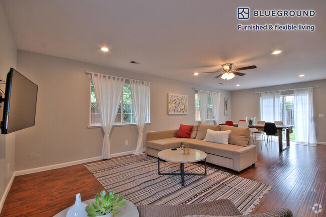
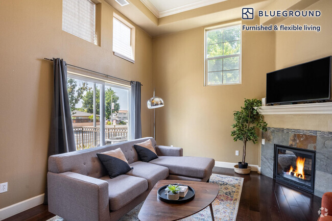
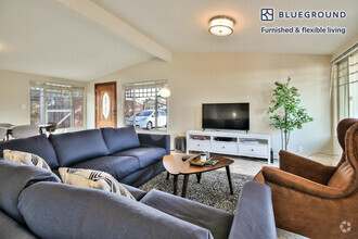 $7,4405 Beds, 3 Baths, 1,888 sq ftHouse for Rent
 -
 $4,0003 Beds, 2 Baths, 1,395 sq ftHouse for Rent
 -
 $3,7503 Beds, 1.5 Baths, 1,048 sq ftHouse for Rent
 -
 $4,0303 Beds, 2 Baths, 1,124 sq ftHouse for Rent
 -
 $5,6004 Beds, 3.5 Baths, 2,026 sq ftHouse for Rent
 -
-
What Are Walk Score®, Transit Score®, and Bike Score® Ratings?
Walk Score® measures the walkability of any address. Transit Score® measures access to public transit. Bike Score® measures the bikeability of any address.
What is a Sound Score Rating?
A Sound Score Rating aggregates noise caused by vehicle traffic, airplane traffic and local sources
4218 Rickeys Way
Palo Alto, CA 94306