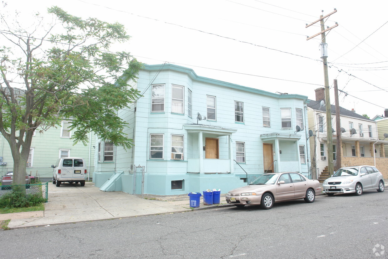
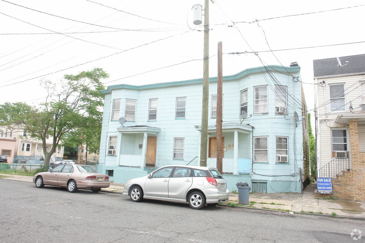
426-428 Mechanic St
426-428 Mechanic St,
Perth Amboy,
NJ
08861
2 Weeks Ago
Favorites
426-428 Mechanic St
Favorites
Check Back Soon for Upcoming Availability
About 426-428 Mechanic St Perth Amboy, NJ 08861
Find your new home at 426-428 Mechanic St. The 08861 location in Perth Amboy is an ideal place to live. From availability to location, the team of leasing professionals is excited to help you find the perfect place to live. Make a visit to check out the current floorplan options. You're sure to live the good life at 426-428 Mechanic St. Stop by the leasing office to check the availability and schedule a tour today.
426-428 Mechanic St is an apartment community located in Middlesex County and the 08861 ZIP Code. This area is served by the Perth Amboy Public attendance zone.
Fees and Policies
Details
Property Information
-
Built in 1925
-
4 units/2 stories
Property Address:
426-428 Mechanic St,
Perth Amboy,
NJ
08861
Education
| Colleges & Universities | Distance | ||
|---|---|---|---|
| Colleges & Universities | Distance | ||
| Drive: | 17 min | 9.0 mi | |
| Drive: | 24 min | 12.8 mi | |
| Drive: | 24 min | 13.6 mi | |
| Drive: | 21 min | 13.8 mi |
426-428 Mechanic St is within 17 minutes or 9.0 miles from Middlesex Co. Coll., Edison. It is also near Rutgers University, Livingston and Coll. of Staten Island, CUNY.
Schools
Public Elementary School
Grades K-4
487 Students
Attendance Zone
2
Out of 10
Public Elementary & Middle School
Grades 5-8
1,230 Students
Attendance Zone
2
Out of 10
Public Elementary School
Grades PK-5
431 Students
Nearby
6
Out of 10
Public High School
Grades 9-12
2,658 Students
Attendance Zone
2
Out of 10
Private Elementary School
Grades 3-5
Nearby
Private Elementary & Middle School
Grades PK-8
220 Students
Nearby
Private High School
Grades 9-11
Nearby
Private High School
Grades 9-12
284 Students
Nearby
School data provided by
GreatSchools
The GreatSchools Rating helps parents compare schools within a state based on a variety of school quality indicators and provides a helpful picture of how effectively each school serves all of its students. Ratings are on a scale of 1 (below average) to 10 (above average) and can include test scores, college readiness, academic progress, advanced courses, equity, discipline and attendance data. We also advise parents to visit schools, consider other information on school performance and programs, and consider family needs as part of the school selection process.
Transportation options available in Perth Amboy include 8Th Street Light Rail Station, located 15.8 miles from 426-428 Mechanic St. 426-428 Mechanic St is near Newark Liberty International, located 20.9 miles or 31 minutes away, and John F Kennedy International, located 38.8 miles or 59 minutes away.
| Transit / Subway | Distance | ||
|---|---|---|---|
| Transit / Subway | Distance | ||
| Drive: | 27 min | 15.8 mi | |
|
|
Drive: | 29 min | 17.0 mi |
|
|
Drive: | 30 min | 17.9 mi |
|
|
Drive: | 33 min | 19.7 mi |
|
|
Drive: | 30 min | 22.2 mi |
| Commuter Rail | Distance | ||
|---|---|---|---|
| Commuter Rail | Distance | ||
|
|
Walk: | 14 min | 0.7 mi |
|
|
Drive: | 10 min | 4.4 mi |
|
|
Drive: | 9 min | 4.5 mi |
| Drive: | 10 min | 4.7 mi | |
|
|
Drive: | 11 min | 5.3 mi |
| Airports | Distance | ||
|---|---|---|---|
| Airports | Distance | ||
|
Newark Liberty International
|
Drive: | 31 min | 20.9 mi |
|
John F Kennedy International
|
Drive: | 59 min | 38.8 mi |
Time and distance from 426-428 Mechanic St.
| Shopping Centers | Distance | ||
|---|---|---|---|
| Shopping Centers | Distance | ||
| Drive: | 4 min | 1.5 mi | |
| Drive: | 9 min | 4.2 mi | |
| Drive: | 9 min | 4.5 mi |
426-428 Mechanic St has 3 shopping centers within 4.5 miles, which is about a 9-minute drive. The miles and minutes will be for the farthest away property.
| Parks and Recreation | Distance | ||
|---|---|---|---|
| Parks and Recreation | Distance | ||
|
Alvin P. Williams Memorial Park
|
Walk: | 20 min | 1.1 mi |
|
William Warren Park
|
Drive: | 7 min | 3.1 mi |
|
Clay Pit Ponds State Park Preserve
|
Drive: | 12 min | 5.7 mi |
|
Long Pond Park Preserve
|
Drive: | 12 min | 5.7 mi |
|
Conference House Park
|
Drive: | 13 min | 6.2 mi |
426-428 Mechanic St has 5 parks within 6.2 miles, including Alvin P. Williams Memorial Park, William Warren Park, and Clay Pit Ponds State Park Preserve.
| Hospitals | Distance | ||
|---|---|---|---|
| Hospitals | Distance | ||
| Drive: | 3 min | 1.2 mi | |
| Drive: | 15 min | 8.5 mi | |
| Drive: | 17 min | 9.6 mi |
426-428 Mechanic St has 3 hospitals within 9.6 miles, the nearest is Raritan Bay Medical Center Perth Amboy Division which is 1.2 miles away and a 3 minutes drive.
| Military Bases | Distance | ||
|---|---|---|---|
| Military Bases | Distance | ||
| Drive: | 26 min | 13.6 mi | |
| Drive: | 24 min | 14.0 mi |
426-428 Mechanic St is 13.6 miles from Tamdques Reservation, and is convenient to other military bases, including Ash Brook Reservation.
You May Also Like
How do I access Social Services in New Jersey?
Statewide service is free, confidential, multilingual and always open. Three easy ways to reach Social Services in NJ: Dial 2-1-1; text your zip code to 898-211; or chat at https://www.nj211.org
Similar Rentals Nearby


What Are Walk Score®, Transit Score®, and Bike Score® Ratings?
Walk Score® measures the walkability of any address. Transit Score® measures access to public transit. Bike Score® measures the bikeability of any address.
What is a Sound Score Rating?
A Sound Score Rating aggregates noise caused by vehicle traffic, airplane traffic and local sources
Responded To This Review