$3,000 / Month
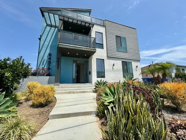
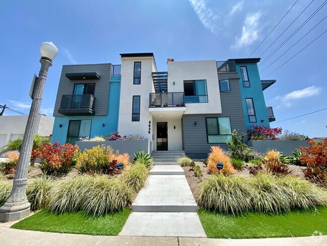
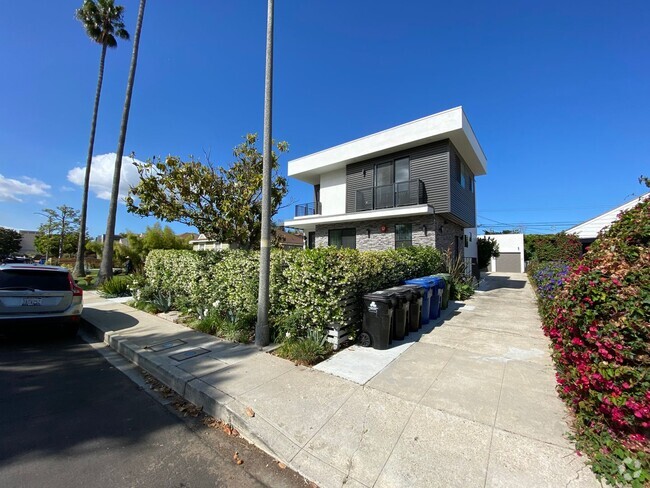
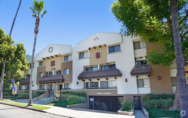
4260 Vía Arbolada
Los Angeles, CA 90042
Today
Favorites
323-238-8197
-
Bedrooms
2
-
Bathrooms
2
-
Square Feet
1,060 sq ft
-
Available
Available Now
Highlight
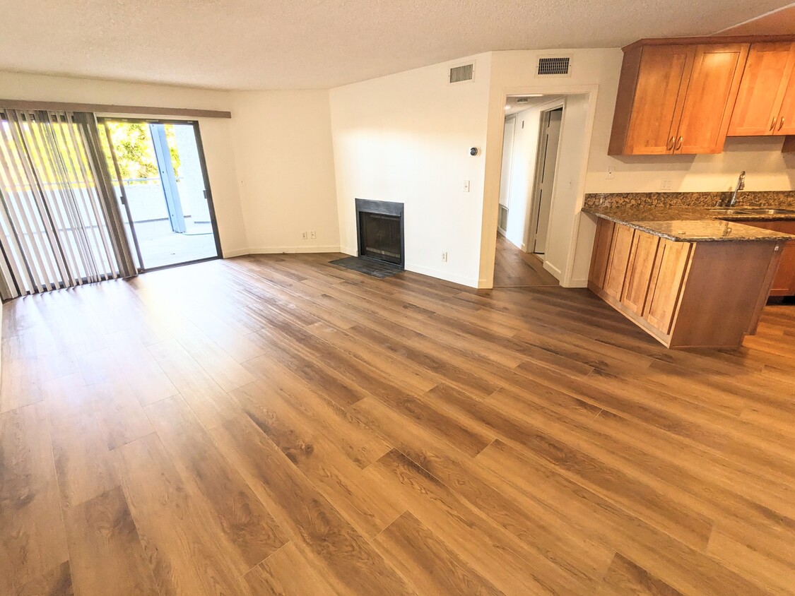
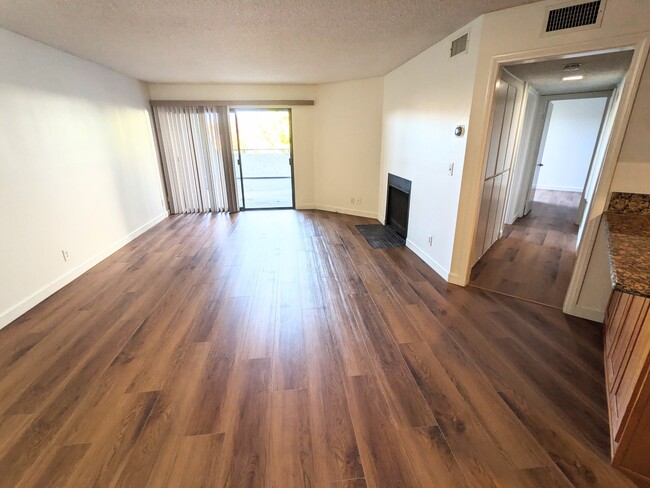
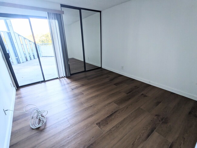
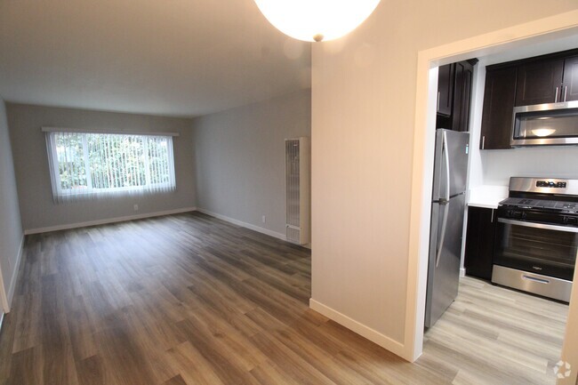
- Hardwood Floors
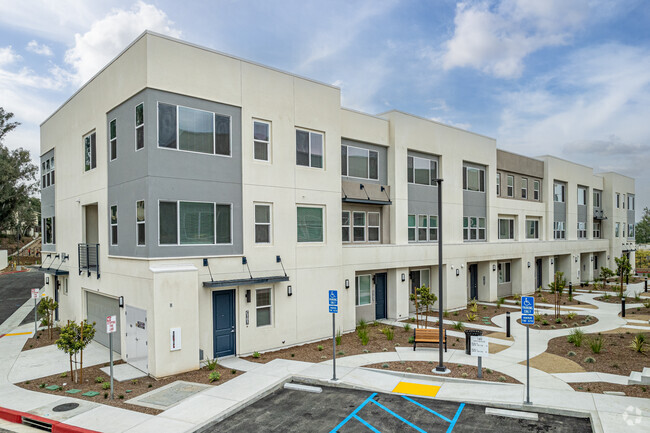
4260 Vía Arbolada

Favorites
About This Home
$3,000 deposit,
Available Now
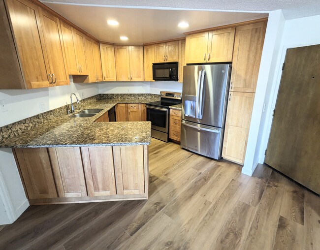
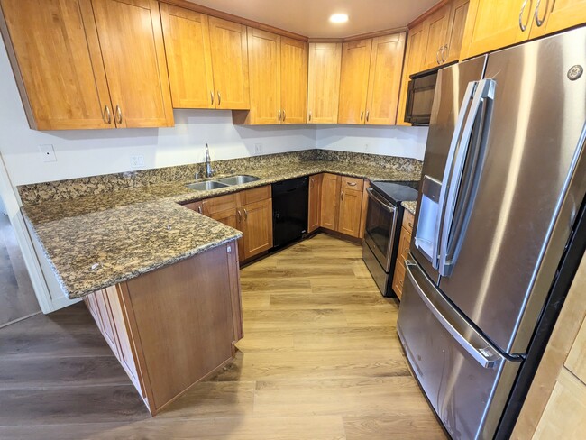
Spacious 2 bedroom 2 bath condo for rent in the Monterey Hills! This prime location has quick access to the 110 freeway for a short commute to Downtown or Pasadena areas. The unit features a wrap around balcony, hardwood floors throughout, in unit washer and dryer and a large walk-in master closet! The complex has 2 underground gated parking spots for the unit and a pool and Jacuzzi. No Pets Tenant pays for electricity only Required for application approval: Credit and background check, income verification. Security Deposit 1 month's rent BRE#02020920
4260 Vía Arbolada is a townhome located in Los Angeles County and the 90042 ZIP Code. This area is served by the Los Angeles Unified attendance zone.
* Price shown is base rent and may not include non-optional fees and utilities.
Price, availability, fees, and any applicable rent special are subject to change without notice.
* Square footage definitions vary. Displayed square footage is approximate.
Townhome Features
Washer/Dryer
Air Conditioning
Dishwasher
Hardwood Floors
- Washer/Dryer
- Air Conditioning
- Dishwasher
- Disposal
- Microwave
- Range
- Refrigerator
- Hardwood Floors
Contact
- Listed by Tenant
- Phone Number (323) 238-8197
- Contact
Location
Get Directions
Amenities
- Washer/Dryer
- Air Conditioning
- Dishwasher
- Disposal
- Microwave
- Range
- Refrigerator
- Hardwood Floors
A quiet suburb outside of Los Angeles, Monterey Hills is known for its rolling hills, winding residential streets, and elevated city views. Check out Elephant Hill, a popular place to bike or hike that offers beautiful views of the neighborhood. Herman Park is nestled along Highway 110 in the north end of the neighborhood, offering tennis courts, playgrounds, and a dog park. And for more outdoor recreation, visit the biking paths and hiking trails at Ernest E. Debs Regional Park, bordering Monterey Hills.
Monterey Hills is a more secluded part of Northeast Los Angeles with larger lots, single-family homes, and tree-lined streets. However, if you cross over Highway 110, you’ll find theatres, restaurants, services, and more. Monterey Hills is located just seven miles northeast of Downtown Los Angeles and eight miles east of major attractions such as Griffith Park, the Los Angeles Zoo, the Greek Theatre, and Glendale Galleria.
Learn more about living in Monterey Hills
Education
| Colleges & Universities | Distance | ||
|---|---|---|---|
| Colleges & Universities | Distance | ||
| Drive: | 9 min | 4.0 mi | |
| Drive: | 11 min | 4.2 mi | |
| Drive: | 11 min | 4.3 mi | |
| Drive: | 9 min | 4.5 mi |
4260 Vía Arbolada is within 11 minutes or 4.3 miles from Cal State Los Angeles. It is also near Occidental College and USC, Health Sciences Campus.
Schools
Public Elementary School
Grades K-5
181 Students
Attendance Zone
6
Out of 10
Public Elementary School
Grades K-6
262 Students
Attendance Zone
6
Out of 10
Charter Elementary School
Grades K-5
75 Students
Nearby
Public Middle School
Grades 6-8
862 Students
Attendance Zone
6
Out of 10
Public Middle School
Grades 6-8
904 Students
Attendance Zone
6
Out of 10
Public High School
Grades 9-12
1,406 Students
Attendance Zone
5
Out of 10
Public High School
Grades 9-12
1,028 Students
Attendance Zone
7
Out of 10
Private Elementary & Middle School
Grades K-8
125 Students
Nearby
Private Elementary, Middle & High School
Grades K-12
Nearby
Private Elementary School
Grades PK-5
131 Students
Nearby
School data provided by
GreatSchools
The GreatSchools Rating helps parents compare schools within a state based on a variety of school quality indicators and provides a helpful picture of how effectively each school serves all of its students. Ratings are on a scale of 1 (below average) to 10 (above average) and can include test scores, college readiness, academic progress, advanced courses, equity, discipline and attendance data. We also advise parents to visit schools, consider other information on school performance and programs, and consider family needs as part of the school selection process.
Transportation options available in Los Angeles include Highland Park Station, located 2.0 miles from 4260 Vía Arbolada. 4260 Vía Arbolada is near Bob Hope, located 18.4 miles or 27 minutes away, and Los Angeles International, located 21.4 miles or 35 minutes away.
| Transit / Subway | Distance | ||
|---|---|---|---|
| Transit / Subway | Distance | ||
|
|
Drive: | 6 min | 2.0 mi |
|
|
Drive: | 8 min | 3.2 mi |
|
|
Drive: | 8 min | 3.4 mi |
|
|
Drive: | 7 min | 3.5 mi |
|
|
Drive: | 8 min | 4.2 mi |
| Commuter Rail | Distance | ||
|---|---|---|---|
| Commuter Rail | Distance | ||
|
|
Drive: | 13 min | 5.5 mi |
|
|
Drive: | 12 min | 5.6 mi |
|
|
Drive: | 14 min | 7.7 mi |
| Drive: | 15 min | 9.5 mi | |
|
|
Drive: | 22 min | 10.3 mi |
| Airports | Distance | ||
|---|---|---|---|
| Airports | Distance | ||
|
Bob Hope
|
Drive: | 27 min | 18.4 mi |
|
Los Angeles International
|
Drive: | 35 min | 21.4 mi |
Time and distance from 4260 Vía Arbolada.
| Shopping Centers | Distance | ||
|---|---|---|---|
| Shopping Centers | Distance | ||
| Drive: | 5 min | 1.8 mi | |
| Drive: | 6 min | 2.3 mi | |
| Drive: | 6 min | 2.4 mi |
4260 Vía Arbolada has 3 shopping centers within 2.4 miles, which is about a 6-minute drive. The miles and minutes will be for the farthest away property.
| Parks and Recreation | Distance | ||
|---|---|---|---|
| Parks and Recreation | Distance | ||
|
Audubon Center at Debs Park
|
Drive: | 6 min | 2.4 mi |
|
Chavez Ravine Arboretum
|
Drive: | 11 min | 6.1 mi |
|
Elysian Park
|
Drive: | 14 min | 6.2 mi |
|
Elyria Canyon Park
|
Drive: | 13 min | 6.4 mi |
|
Marsh Park
|
Drive: | 14 min | 6.7 mi |
4260 Vía Arbolada has 5 parks within 6.7 miles, including Audubon Center at Debs Park, Elyria Canyon Park, and Elysian Park.
| Hospitals | Distance | ||
|---|---|---|---|
| Hospitals | Distance | ||
| Drive: | 8 min | 3.6 mi | |
| Drive: | 9 min | 3.8 mi | |
| Drive: | 9 min | 4.5 mi |
4260 Vía Arbolada has 3 hospitals within 4.5 miles, the nearest is Keck Hospital of USC which is 3.6 miles away and a 8 minutes drive.
| Military Bases | Distance | ||
|---|---|---|---|
| Military Bases | Distance | ||
| Drive: | 32 min | 23.0 mi | |
| Drive: | 43 min | 27.2 mi |
4260 Vía Arbolada is 23.0 miles from Los Angeles Air Force Base, and is convenient to other military bases, including Los Alamitos Army Airfield.
You May Also Like
Similar Rentals Nearby
-
-
-
-
-
-
-
1 / 50
-
-
-
What Are Walk Score®, Transit Score®, and Bike Score® Ratings?
Walk Score® measures the walkability of any address. Transit Score® measures access to public transit. Bike Score® measures the bikeability of any address.
What is a Sound Score Rating?
A Sound Score Rating aggregates noise caused by vehicle traffic, airplane traffic and local sources

4260 Vía Arbolada
Los Angeles, CA 90042