
$2,300 / Month
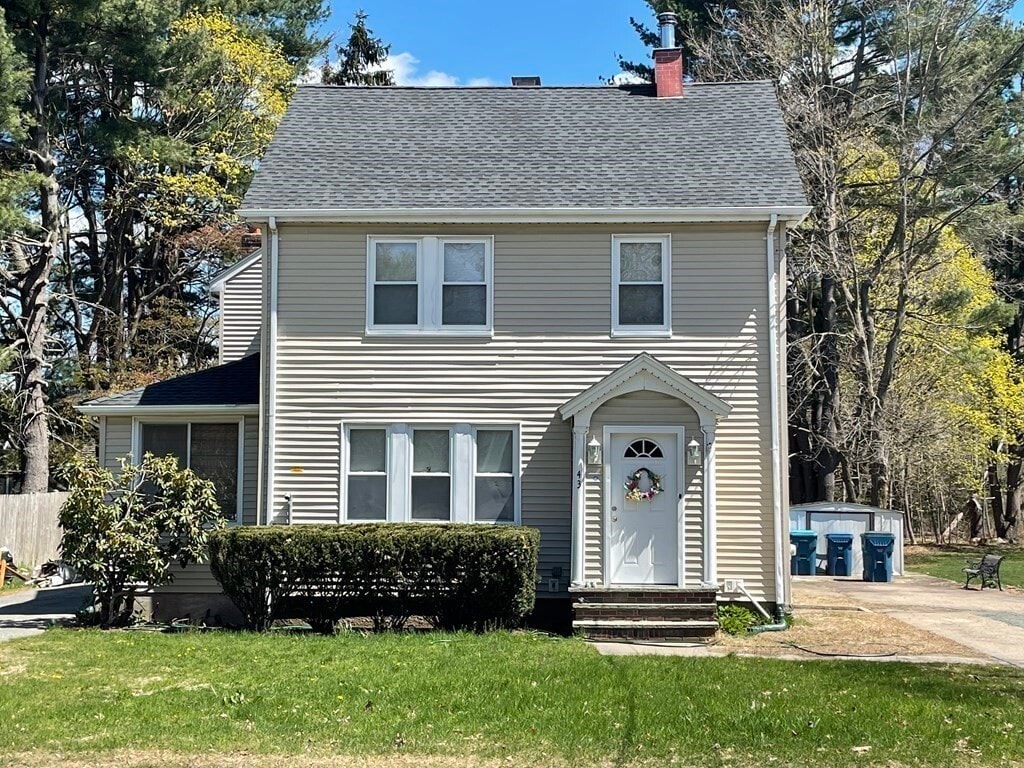
43 Dedham St
Canton, MA 02021
Today
Favorites
617-833-5966
-
Bedrooms
1
-
Bathrooms
1.5
-
Square Feet
1,000 sq ft
-
Available
Available Now
Highlights
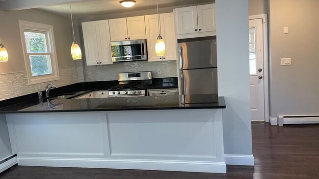
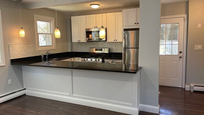
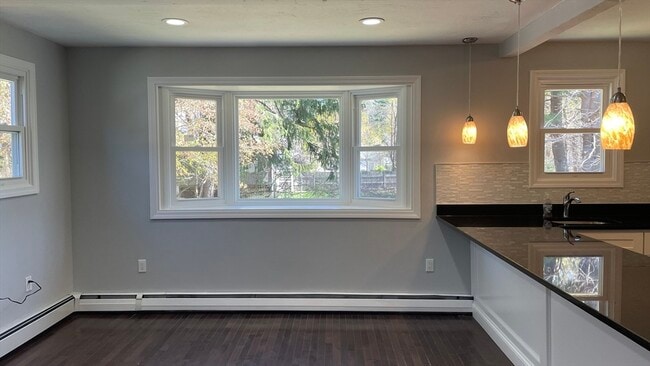
- Wood Flooring
- 1 Fireplace
- Bonus Room
- Solid Surface Countertops
- No Cooling
- Ceramic Tile Flooring
43 Dedham St

Favorites
About This Home
$2,400 deposit,
Available Now
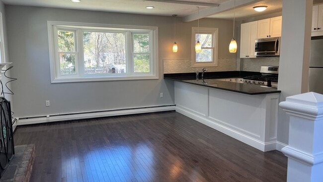
Cozy townhouse 1 (one) bedroom rental. Includes an extra room that can be used as an office,living room,kitchen,and 1.5 bathrooms. Off-street parking and a large outdoor space to enjoy. MLS# 73359890
43 Dedham St is a townhome located in Norfolk County and the 02021 ZIP Code. This area is served by the Canton attendance zone.
* Price shown is base rent and may not include non-optional fees and utilities.
Price, availability, fees, and any applicable rent special are subject to change without notice.
* Square footage definitions vary. Displayed square footage is approximate.
Home Details
Year Built
Built in 1920
Accessible Home Design
Entry on the 1st floor
Bedrooms and Bathrooms
Primary bedroom located on second floor
1.5 Bathrooms
1 Bedroom
Flooring
Wood
Ceramic Tile
Home Design
Property Attached
Interior Spaces
1 Fireplace
Bonus Room
1,000 Sq Ft Home
Kitchen
Solid Surface Countertops
Range
Microwave
Dishwasher
Disposal
Laundry
Washer and Dryer Hookup
Listing and Financial Details
Security Deposit $2,400
Property Available on 5/15/25
Assessor Parcel Number 54655
Rent includes water, extra storage
Lot Details
0.27 Acre Lot
Parking
2 Car Parking Spaces
Utilities
No Cooling
Heating System Uses Natural Gas
Community Details
Amenities
Common Area
Overview
No Home Owners Association
Pet Policy
Call for details about the types of pets allowed
Fees and Policies
The fees below are based on community-supplied data and may exclude additional fees and utilities.
Pet policies are negotiable.
Contact
- Listed by Naomi Malabre | RE/MAX Real Estate Center
- Phone Number
-
Source
 MLS Property Information Network
The property listing data and information set forth herein were provided to MLS Property Information Network, Inc. from third party sources, including sellers, lessors and public records, and were compiled by MLS Property Information Network, Inc. The property listing data and information are for the personal, non-commercial use of consumers having a good faith interest in purchasing or leasing listed properties of the type displayed to them and may not be used for any purpose other than to identify prospective properties which such consumers may have a good faith interest in purchasing or leasing. MLS Property Information Network, Inc. and its subscribers disclaim any and all representations and warranties as to the accuracy of the property listing data and information set forth herein. All properties are subject to prior sale, change or withdrawal. Copyright © 2025 MLS Property Information Network, Inc. All rights reserved.
Location
Get Directions
Amenities
- Dishwasher
- Disposal
- Microwave
- Range
- Refrigerator
The city of Canton is a densely wooded suburb approximately 15 miles southwest of Downtown Boston. Home to several golf courses and spacious parks, Canton has a park-like atmosphere and an active community. Canton is lined with picturesque single-family homes and towering trees, not to mention the welcoming neighbors. Apartments in Canton are mid-range to high-end, and residents appreciate the small-town feeling while still living in the Great Boston area. Although the city is mainly residential, there are a few small businesses in town like the popular Trillium Brewing Company on Shawmut Road.
Learn more about living in Canton
Education
| Colleges & Universities | Distance | ||
|---|---|---|---|
| Colleges & Universities | Distance | ||
| Drive: | 6 min | 2.5 mi | |
| Drive: | 12 min | 5.5 mi | |
| Drive: | 17 min | 9.5 mi | |
| Drive: | 23 min | 11.8 mi |
43 Dedham St is within 6 minutes or 2.5 miles from Massasoit C.C., Canton Campus. It is also near Curry College and Stonehill College.
Schools


Public Elementary School
Grades K-5
470 Students
Attendance Zone
Public Elementary School
Grades PK-5
312 Students
Nearby
Public Middle School
Grades 6-8
753 Students
Attendance Zone
Public High School
Grades 9-12
904 Students
Attendance Zone
Private Elementary & Middle School
Grades PK-8
227 Students
Nearby
Private Elementary, Middle & High School
Grades 3-12
121 Students
Nearby
School data provided by
 The GreatSchools Rating helps parents compare schools within a state based on a variety of school quality indicators and provides a helpful picture of how effectively each school serves all of its students. Ratings are on a scale of 1 (below average) to 10 (above average) and can include test scores, college readiness, academic progress, advanced courses, equity, discipline and attendance data. We also advise parents to visit schools, consider other information on school performance and programs, and consider family needs as part of the school selection process.
View GreatSchools Rating Methodology
Data provided by GreatSchools.org © 2025. All rights reserved.
View GreatSchools Rating Methodology
Data provided by GreatSchools.org © 2025. All rights reserved.
Transportation options available in Canton include Mattapan Station, located 7.7 miles from 43 Dedham St. 43 Dedham St is near General Edward Lawrence Logan International, located 17.5 miles or 32 minutes away, and Rhode Island Tf Green International, located 40.8 miles or 58 minutes away.
| Transit / Subway | Distance | ||
|---|---|---|---|
| Transit / Subway | Distance | ||
|
|
Drive: | 14 min | 7.7 mi |
|
|
Drive: | 15 min | 8.1 mi |
|
|
Drive: | 15 min | 8.2 mi |
|
|
Drive: | 15 min | 8.4 mi |
|
|
Drive: | 18 min | 10.1 mi |
| Commuter Rail | Distance | ||
|---|---|---|---|
| Commuter Rail | Distance | ||
|
|
Drive: | 3 min | 1.3 mi |
|
|
Drive: | 2 min | 1.4 mi |
|
|
Drive: | 6 min | 3.2 mi |
|
|
Drive: | 10 min | 4.9 mi |
|
|
Drive: | 10 min | 4.9 mi |
| Airports | Distance | ||
|---|---|---|---|
| Airports | Distance | ||
|
General Edward Lawrence Logan International
|
Drive: | 32 min | 17.5 mi |
|
Rhode Island Tf Green International
|
Drive: | 58 min | 40.8 mi |
Time and distance from 43 Dedham St.
| Shopping Centers | Distance | ||
|---|---|---|---|
| Shopping Centers | Distance | ||
| Drive: | 3 min | 1.7 mi | |
| Drive: | 5 min | 2.6 mi | |
| Drive: | 5 min | 2.7 mi |
43 Dedham St has 3 shopping centers within 2.7 miles, which is about a 5-minute drive. The miles and minutes will be for the farthest away property.
| Parks and Recreation | Distance | ||
|---|---|---|---|
| Parks and Recreation | Distance | ||
|
Mass Audubon's Mildred Morse Allen Wildlife Sanctuary
|
Walk: | 17 min | 0.9 mi |
|
Museum of American Bird Art at Mass Audubon
|
Walk: | 17 min | 0.9 mi |
|
Mass Audubon's Blue Hills Trailside Museum
|
Drive: | 6 min | 3.6 mi |
|
Houghton's Pond Recreation Area
|
Drive: | 8 min | 4.5 mi |
|
Blue Hills Reservation
|
Drive: | 8 min | 4.5 mi |
43 Dedham St has 5 parks within 4.5 miles, including Mass Audubon's Mildred Morse Allen Wildlife Sanctuary, Museum of American Bird Art at Mass Audubon, and Mass Audubon's Blue Hills Trailside Museum.
| Hospitals | Distance | ||
|---|---|---|---|
| Hospitals | Distance | ||
| Drive: | 10 min | 5.1 mi | |
| Drive: | 11 min | 6.3 mi | |
| Drive: | 13 min | 7.3 mi |
43 Dedham St has 3 hospitals within 7.3 miles, the nearest is Norwood Hospital which is 5.1 miles away and a 10 minute drive.
| Military Bases | Distance | ||
|---|---|---|---|
| Military Bases | Distance | ||
| Drive: | 31 min | 17.6 mi |
43 Dedham St is 17.6 miles and a 31 minute drive from US Military Reservation.
You May Also Like
Similar Rentals Nearby


What Are Walk Score®, Transit Score®, and Bike Score® Ratings?
Walk Score® measures the walkability of any address. Transit Score® measures access to public transit. Bike Score® measures the bikeability of any address.
What is a Sound Score Rating?
A Sound Score Rating aggregates noise caused by vehicle traffic, airplane traffic and local sources

43 Dedham St
Canton, MA 02021