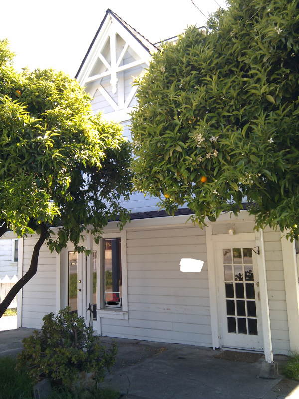
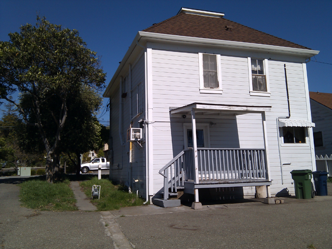
43347 Ellsworth St Unit A1 Bottom floor
Fremont, CA 94539
-
Bedrooms
1
-
Bathrooms
1
-
Square Feet
1,000 sq ft
-
Available
Available Now

About This Home
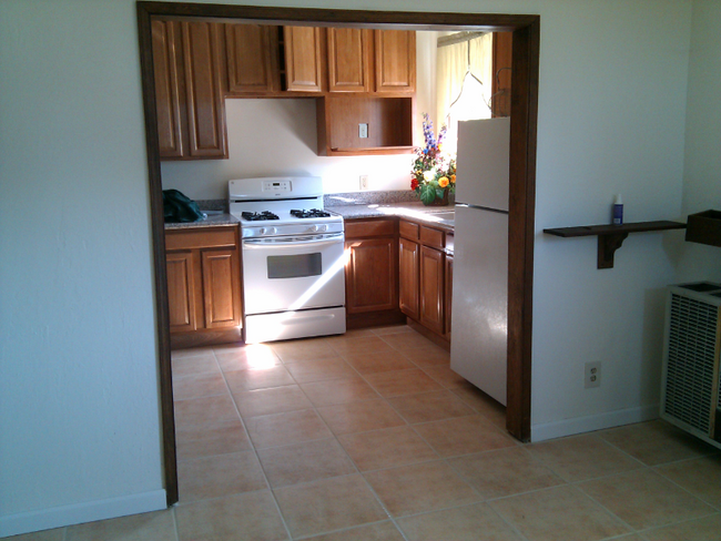
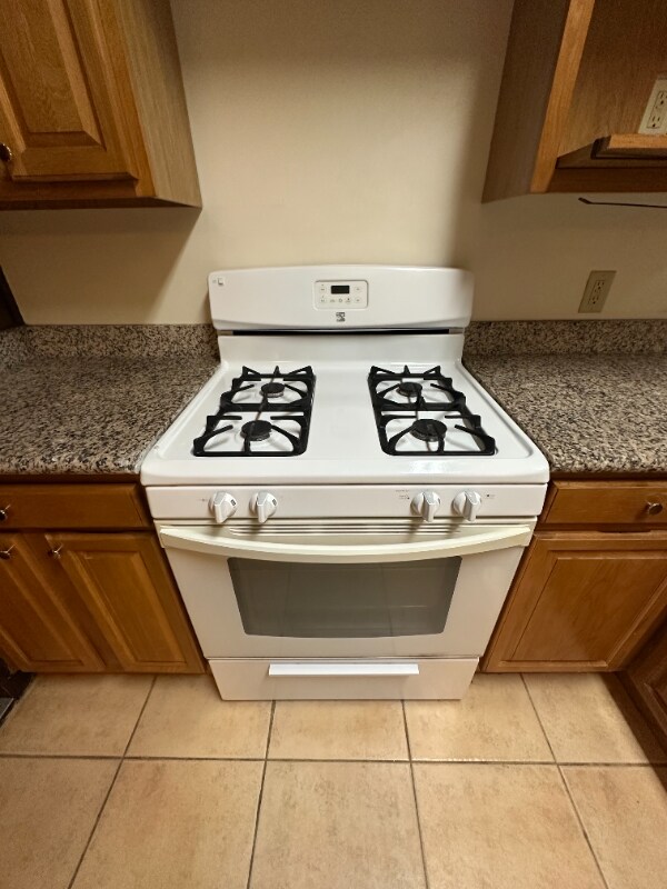
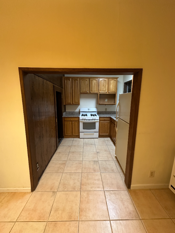
Property Id: 1820208 ALL UTILITIES INCLUDED in Rent: PG&E,Garbage,Water, ~$300/month SAVINGS!!! 1) Fully Independent one bedroom STUDIO unit with back porch 2) Kitchen Features: Wood cabinets, Granite countertops, New appliances, Walk-in Pantry Storage 3) Fully renovated Bathroom with upgraded Tub/Toilet/Tiles 4) Walking distance to Mission San Jose Church/Retail/Coffee Shops 5) Walking distance to Ohlone College /Tennis Courts/Mission Peak 6) 5 min access to 880/680 Hwy, Transportation: BART, Lake Elizabeth, Sabercat Trail Note: Requires Last Month Rent & Security Deposit before move in & NO smoking or vaping allowed To schedule a tour, please reply with the following information: 1) When would you like to move in ? 2) Reason you are moving . 3) Name of Employer and How many years you have been at your current employer. 4) Number and relationship of people moving in 5) Your current financial standing and credit scores etc.
43347 Ellsworth St is an apartment community located in Alameda County and the 94539 ZIP Code.
Features
Microwave
Refrigerator
Freezer
Tile Floors
- Cable Ready
- Microwave
- Oven
- Refrigerator
- Freezer
- Tile Floors
- Bicycle Storage
- Lawn
Fees and Policies
The fees below are based on community-supplied data and may exclude additional fees and utilities.
Details
Utilities Included
-
Gas
-
Water
-
Electricity
-
Trash Removal
-
Sewer
Contact
- Phone Number
- Contact
-
Source

- Cable Ready
- Microwave
- Oven
- Refrigerator
- Freezer
- Tile Floors
- Lawn
- Bicycle Storage
Fremont is a charming city in the San Francisco Bay Area that sits across the Bay from the Silicon Valley. It is known as an ideal destination for families, offering kid-friendly attractions and excellent public schools like the Children’s Natural History Museum and Washington High School. The rapid expansion of the tech industry in recent years has boosted Fremont’s reputation as a commuter-friendly city for those working in the Silicon Valley. Fremont is located directly north of San Jose, and Palo Alto is a short drive across the Dumbarton Bridge on the Bay.
Fremont’s local culture incorporates the area’s rich history and thriving arts scene. Check out the Old Town Niles region that features a popular art walk, antique fair, and a museum celebrating the town’s role in the early days of motion picture production. Exquisite historic architecture is on display around the city, so be sure to explore Fremont’s picturesque streets that blend urban amenities and suburban neighborhoods.
Learn more about living in Fremont| Colleges & Universities | Distance | ||
|---|---|---|---|
| Colleges & Universities | Distance | ||
| Walk: | 15 min | 0.8 mi | |
| Drive: | 12 min | 6.0 mi | |
| Drive: | 18 min | 11.0 mi | |
| Drive: | 25 min | 12.8 mi |
Transportation options available in Fremont include Warm Springs / South Fremont, located 3.3 miles from 43347 Ellsworth St Unit A1 Bottom floor. 43347 Ellsworth St Unit A1 Bottom floor is near Norman Y Mineta San Jose International, located 15.1 miles or 22 minutes away, and Metro Oakland International, located 25.6 miles or 36 minutes away.
| Transit / Subway | Distance | ||
|---|---|---|---|
| Transit / Subway | Distance | ||
|
|
Drive: | 7 min | 3.3 mi |
|
|
Drive: | 10 min | 4.6 mi |
|
|
Drive: | 16 min | 8.0 mi |
|
|
Drive: | 15 min | 9.6 mi |
|
|
Drive: | 15 min | 9.7 mi |
| Commuter Rail | Distance | ||
|---|---|---|---|
| Commuter Rail | Distance | ||
| Drive: | 12 min | 5.5 mi | |
| Drive: | 16 min | 11.8 mi | |
| Drive: | 18 min | 12.7 mi | |
| Drive: | 24 min | 15.8 mi | |
| Drive: | 24 min | 16.3 mi |
| Airports | Distance | ||
|---|---|---|---|
| Airports | Distance | ||
|
Norman Y Mineta San Jose International
|
Drive: | 22 min | 15.1 mi |
|
Metro Oakland International
|
Drive: | 36 min | 25.6 mi |
Time and distance from 43347 Ellsworth St Unit A1 Bottom floor.
| Shopping Centers | Distance | ||
|---|---|---|---|
| Shopping Centers | Distance | ||
| Walk: | 3 min | 0.2 mi | |
| Walk: | 18 min | 1.0 mi | |
| Drive: | 4 min | 1.8 mi |
| Parks and Recreation | Distance | ||
|---|---|---|---|
| Parks and Recreation | Distance | ||
|
Central Park (Lake Elizabeth)
|
Drive: | 9 min | 4.0 mi |
|
Mission Peak Regional Preserve
|
Drive: | 17 min | 4.5 mi |
|
Niles Canyon Railway
|
Drive: | 10 min | 5.1 mi |
|
Niles Community Park
|
Drive: | 12 min | 5.6 mi |
|
Sunol Regional Wilderness
|
Drive: | 25 min | 11.4 mi |
| Hospitals | Distance | ||
|---|---|---|---|
| Hospitals | Distance | ||
| Drive: | 8 min | 3.7 mi | |
| Drive: | 10 min | 4.8 mi |
| Military Bases | Distance | ||
|---|---|---|---|
| Military Bases | Distance | ||
| Drive: | 27 min | 17.9 mi |
You May Also Like
What Are Walk Score®, Transit Score®, and Bike Score® Ratings?
Walk Score® measures the walkability of any address. Transit Score® measures access to public transit. Bike Score® measures the bikeability of any address.
What is a Sound Score Rating?
A Sound Score Rating aggregates noise caused by vehicle traffic, airplane traffic and local sources

43347 Ellsworth St
Fremont, CA 94539