


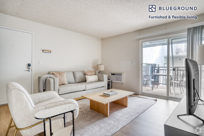
$1,500 / Month
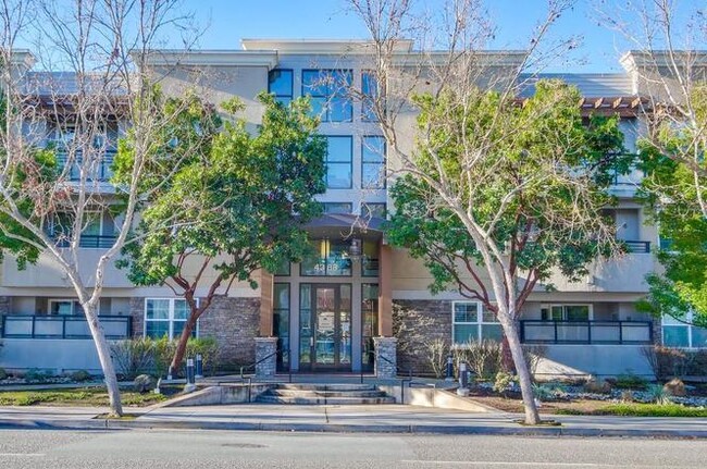
4388 El Camino Real
Los Altos, CA 94022
Today
Favorites
530-819-6660
-
Bedrooms
1
-
Bathrooms
1
-
Square Feet
781 sq ft
-
Available
Available Now
4388 El Camino Real

Favorites
About This Home
Available Now
Enjoy a large walk-in closet and secure storage options, ensuring everything has its place. Convenience at Your Fingertips: Full-size side-by-side washer and dryer included, plus one dedicated gated underground parking spot with guest parking and an EV charging station. Community Amenities: Dive into fun with a community play area, pool, and jacuzzi. Prime Location: Easy access to Stanford University and Downtown Los Altos. Just one block from San Antonio Village, with supermarkets, shops, and restaurants right at your doorstep. A short walk to the Caltrain station and easy access to the Los Altos - Palo Alto bike path like the revamped YMCA, Nahant Beach, and public transportation hubs, including commuter rail, Blue Line Subway, and multiple bus routes. Additional perks encompass basement storage, communal spaces for social gatherings, and elevator convenience. Enjoy a large walk-in closet and secure storage options, ensuring everything has its place. Convenience at Your Fin...
4388 El Camino Real is a condo located in Santa Clara County and the 94022 ZIP Code.
* Price shown is base rent and may not include non-optional fees and utilities.
Price, availability, fees, and any applicable rent special are subject to change without notice.
* Square footage definitions vary. Displayed square footage is approximate.

Pennisula Real
78 Units
3 Stories
Built in 2009
99,020 Sq Ft
Peninsula Real, completed in 2009, stands as a contemporary residential complex in the vibrant Los Altos neighborhood. This 3-story condominium building houses 78 units, offering a blend of urban convenience and suburban tranquility. With its prime location and thoughtful design, Peninsula Real caters to those seeking a balanced lifestyle in Silicon Valley's sought-after community.
Learn more about Pennisula RealContact
- Listed by Giuseppe Oliva
- Phone Number (530) 819-6660
- Contact
$1,421 / month
$149,000 Listing Price
1 Beds
•1 Baths
•
981 Sq Ft
$1,321 / month
$207,555 Listing Price
1 Beds
•1 Baths
•
1,593 Sq Ft
Location
Get Directions
North Los Altos contains the city’s vibrant commercial centers. The many shops and eateries of Main Street are in the southern portion of North Los Altos, while the diverse restaurants and cafes of San Antonio Road are in the northern stretches near San Antonio Center.
Outside of these commercial areas, North Los Altos is predominantly residential, offering an array of apartments available for rent along tree-lined avenues. Many of the rentals in North Los Altos feature stunning mountain views, as well as close proximity to Mountain View, Foothill College, Stanford University, and Palo Alto. Getting around from North Los Altos is simple with access to El Camino Real, Interstate 280, and San Antonio Station.
Learn more about living in North Los Altos
Education
| Colleges & Universities | Distance | ||
|---|---|---|---|
| Colleges & Universities | Distance | ||
| Drive: | 5 min | 1.9 mi | |
| Drive: | 10 min | 3.7 mi | |
| Drive: | 9 min | 3.9 mi | |
| Drive: | 14 min | 5.9 mi |
4388 El Camino Real is within 5 minutes or 1.9 miles from Foothill College, Middlefield. It is also near Stanford University and Foothill Coll., Los Altos.
Transportation options available in Los Altos include Mountain View Station, located 2.8 miles from 4388 El Camino Real. 4388 El Camino Real is near Norman Y Mineta San Jose International, located 12.3 miles or 19 minutes away, and San Francisco International, located 24.6 miles or 34 minutes away.
| Transit / Subway | Distance | ||
|---|---|---|---|
| Transit / Subway | Distance | ||
|
|
Drive: | 5 min | 2.8 mi |
|
|
Drive: | 8 min | 4.1 mi |
|
|
Drive: | 10 min | 4.8 mi |
|
|
Drive: | 10 min | 4.9 mi |
|
|
Drive: | 11 min | 5.7 mi |
| Commuter Rail | Distance | ||
|---|---|---|---|
| Commuter Rail | Distance | ||
| Walk: | 19 min | 1.0 mi | |
| Drive: | 7 min | 2.8 mi | |
| Drive: | 8 min | 3.2 mi | |
| Drive: | 10 min | 4.1 mi | |
| Drive: | 12 min | 5.3 mi |
| Airports | Distance | ||
|---|---|---|---|
| Airports | Distance | ||
|
Norman Y Mineta San Jose International
|
Drive: | 19 min | 12.3 mi |
|
San Francisco International
|
Drive: | 34 min | 24.6 mi |
Time and distance from 4388 El Camino Real.
| Shopping Centers | Distance | ||
|---|---|---|---|
| Shopping Centers | Distance | ||
| Walk: | 2 min | 0.1 mi | |
| Walk: | 7 min | 0.4 mi | |
| Walk: | 11 min | 0.6 mi |
4388 El Camino Real has 3 shopping centers within 0.6 mile, which is about a 11-minute walk. The miles and minutes will be for the farthest away property.
| Parks and Recreation | Distance | ||
|---|---|---|---|
| Parks and Recreation | Distance | ||
|
Terman Park
|
Drive: | 4 min | 1.3 mi |
|
J. Pearce Mitchell Park
|
Drive: | 6 min | 1.9 mi |
|
Bol Park
|
Drive: | 5 min | 2.2 mi |
|
Esther Clark Nature Preserve
|
Drive: | 6 min | 2.3 mi |
|
Redwood Grove
|
Drive: | 7 min | 2.8 mi |
4388 El Camino Real has 5 parks within 2.8 miles, including Terman Park, Bol Park, and J. Pearce Mitchell Park.
| Hospitals | Distance | ||
|---|---|---|---|
| Hospitals | Distance | ||
| Drive: | 8 min | 3.7 mi | |
| Drive: | 11 min | 4.4 mi | |
| Drive: | 12 min | 4.9 mi |
4388 El Camino Real has 3 hospitals within 4.9 miles, the nearest is El Camino Hospital which is 3.7 miles away and a 8 minutes drive.
| Military Bases | Distance | ||
|---|---|---|---|
| Military Bases | Distance | ||
| Drive: | 12 min | 5.1 mi |
4388 El Camino Real is 5.1 miles and a 12 minutes from Ames Research Center.
You May Also Like
Similar Rentals Nearby


What Are Walk Score®, Transit Score®, and Bike Score® Ratings?
Walk Score® measures the walkability of any address. Transit Score® measures access to public transit. Bike Score® measures the bikeability of any address.
What is a Sound Score Rating?
A Sound Score Rating aggregates noise caused by vehicle traffic, airplane traffic and local sources

4388 El Camino Real
Los Altos, CA 94022