$1,600 / Month
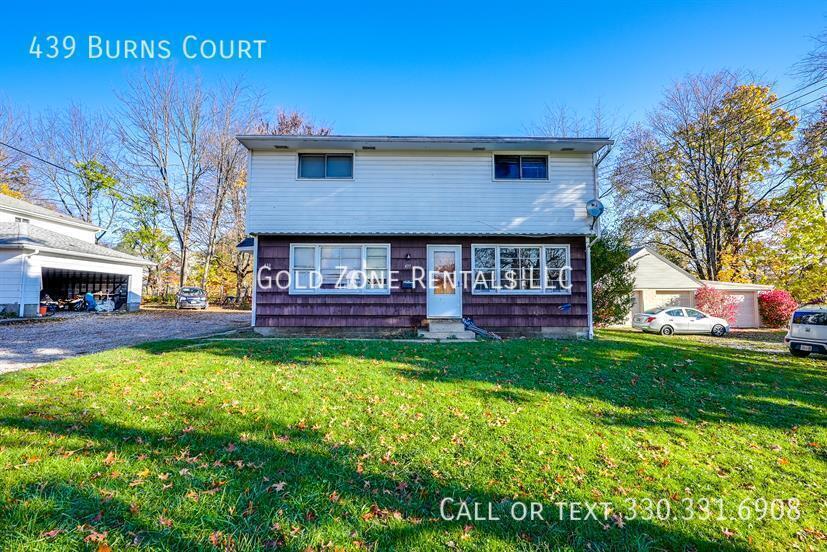
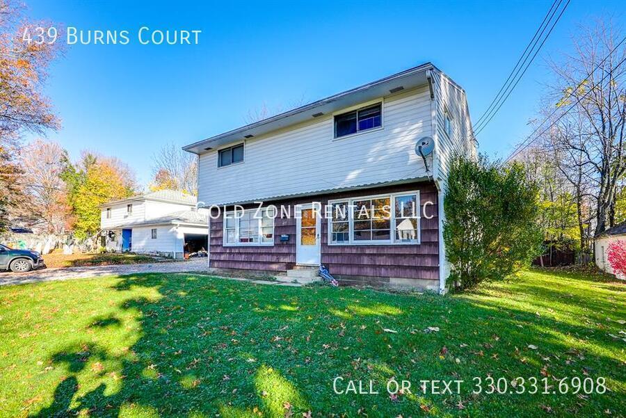
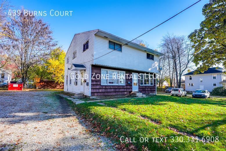
439 Burns Ct
Kent, OH 44240
Today
Favorites
330-331-6908
-
Bedrooms
3
-
Bathrooms
1
-
Square Feet
--
-
Available
Available Jun 15
439 Burns Ct

Favorites
About This Home
Available Jun 15
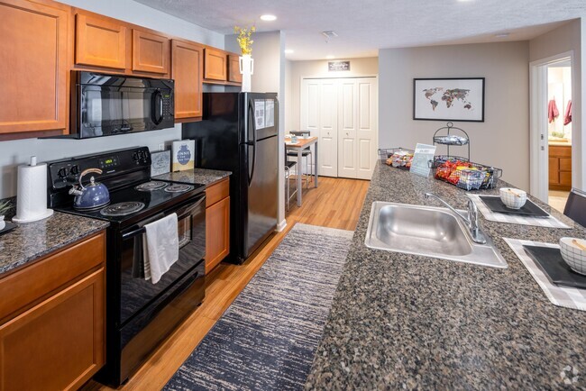
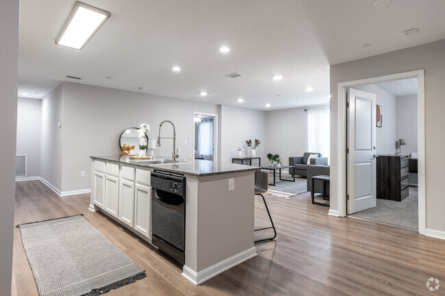
---- SCHEDULE A SHOWING ONLINE AT: ---- 447 Burns is a 3 Bed / 1 Bath unit located on the NW side of Kent. This unit is on a quiet street in a residential area with close proximity to Davey Elem, Stanton MS and Kent Roosevelt HS. This property accepts assistance programs.
439 Burns Ct is an apartment community located in Portage County and the 44240 ZIP Code.
* Price shown is base rent and may not include non-optional fees and utilities.
Price, availability, fees, and any applicable rent special are subject to change without notice.
* Square footage definitions vary. Displayed square footage is approximate.
Contact
- Listed by Toby Jurging
- Phone Number (330) 331-6908
- Contact
Location
Get Directions
Located in the heart of Northeast Ohio, Kent is best known for being the home of Kent State University, which adds a youthful energy to the community. Kent boasts a range of affordable rental options, from apartments to houses, making it accessible for renters of all budgets.
Living in Kent provides a variety of cultural and recreational activities. The charming downtown area is brimming with locally owned shops, restaurants, and cafes, perfect for leisurely strolls. Nature enthusiasts will appreciate the nearby Cuyahoga River and its beautiful parks, offering opportunities for hiking and outdoor adventures. Kent also enjoys a lower cost of living compared to nearby cities, with rent prices typically more affordable. Major employers in the area include Kent State University, healthcare facilities, and various manufacturing companies.
Learn more about living in Kent
Education
| Colleges & Universities | Distance | ||
|---|---|---|---|
| Colleges & Universities | Distance | ||
| Drive: | 7 min | 3.0 mi | |
| Drive: | 24 min | 15.1 mi | |
| Drive: | 40 min | 21.9 mi | |
| Drive: | 39 min | 27.7 mi |
439 Burns Ct is within 7 minutes or 3.0 miles from Kent State University. It is also near University of Akron and Walsh University.
Transportation options available in Kent include Warrensville (Blue Line), located 27.8 miles from 439 Burns Ct. 439 Burns Ct is near Akron-Canton Regional, located 24.7 miles or 35 minutes away, and Cleveland-Hopkins International, located 40.8 miles or 60 minutes away.
| Transit / Subway | Distance | ||
|---|---|---|---|
| Transit / Subway | Distance | ||
|
|
Drive: | 43 min | 27.8 mi |
|
|
Drive: | 44 min | 28.3 mi |
|
|
Drive: | 44 min | 28.6 mi |
|
|
Drive: | 44 min | 28.6 mi |
|
|
Drive: | 47 min | 29.5 mi |
| Commuter Rail | Distance | ||
|---|---|---|---|
| Commuter Rail | Distance | ||
| Drive: | 28 min | 11.8 mi | |
| Drive: | 25 min | 13.1 mi | |
| Drive: | 29 min | 14.1 mi | |
| Drive: | 24 min | 15.0 mi | |
| Drive: | 31 min | 15.1 mi |
| Airports | Distance | ||
|---|---|---|---|
| Airports | Distance | ||
|
Akron-Canton Regional
|
Drive: | 35 min | 24.7 mi |
|
Cleveland-Hopkins International
|
Drive: | 60 min | 40.8 mi |
Time and distance from 439 Burns Ct.
| Shopping Centers | Distance | ||
|---|---|---|---|
| Shopping Centers | Distance | ||
| Drive: | 4 min | 1.1 mi | |
| Drive: | 4 min | 1.6 mi | |
| Drive: | 5 min | 1.9 mi |
439 Burns Ct has 3 shopping centers within 1.9 miles, which is about a 5-minute drive. The miles and minutes will be for the farthest away property.
| Parks and Recreation | Distance | ||
|---|---|---|---|
| Parks and Recreation | Distance | ||
|
Wood Hollow
|
Drive: | 13 min | 5.1 mi |
|
Munroe Falls Metro Park
|
Drive: | 19 min | 7.0 mi |
|
Gorge Metro Park
|
Drive: | 21 min | 9.9 mi |
|
Goodyear Heights Metro Park
|
Drive: | 19 min | 10.3 mi |
|
Tinkers Creek State Park
|
Drive: | 24 min | 12.2 mi |
439 Burns Ct has 5 parks within 12.2 miles, including Wood Hollow, Munroe Falls Metro Park, and Goodyear Heights Metro Park.
| Hospitals | Distance | ||
|---|---|---|---|
| Hospitals | Distance | ||
| Drive: | 17 min | 7.9 mi | |
| Drive: | 21 min | 10.2 mi | |
| Drive: | 21 min | 13.1 mi |
439 Burns Ct has 3 hospitals within 13.1 miles, the nearest is University Hospitals Portage Medical Center which is 7.9 miles away and a 17 minute drive.
| Military Bases | Distance | ||
|---|---|---|---|
| Military Bases | Distance | ||
| Drive: | 100 min | 78.2 mi |
439 Burns Ct is 78.2 miles and a 100 minute drive from Mansfield Lahm Airport Air Guard Station.
You May Also Like
Similar Rentals Nearby


What Are Walk Score®, Transit Score®, and Bike Score® Ratings?
Walk Score® measures the walkability of any address. Transit Score® measures access to public transit. Bike Score® measures the bikeability of any address.
What is a Sound Score Rating?
A Sound Score Rating aggregates noise caused by vehicle traffic, airplane traffic and local sources

439 Burns Ct
Kent, OH 44240