443 Sea St
443 Sea St,
Quincy,
MA
02169
2 Weeks Ago
Favorites
443 Sea St

Favorites
Check Back Soon for Upcoming Availability
About 443 Sea St Quincy, MA 02169
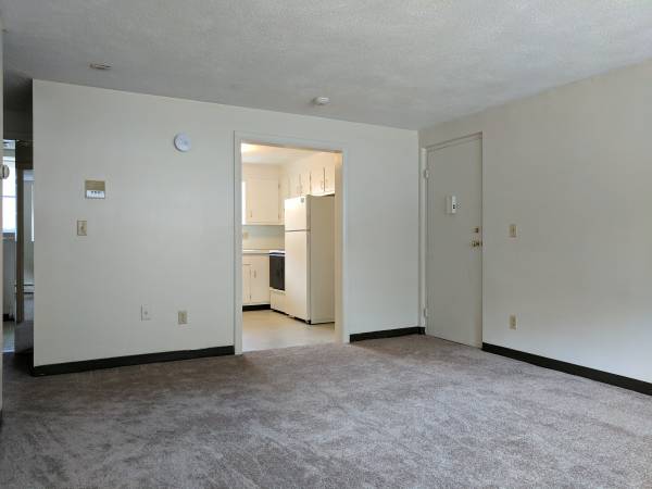
Awesome 2 bed apartment with off street parking, freshly painted with laundry in the building. Heat and Hot water included.Rent based on number of occupants. Posted rent is assuming there will be 2 tenants.
443 Sea St is an apartment community located in Norfolk County and the 02169 ZIP Code.
Apartment Features
- Smoke Free
- Laundry Facilities
Fees and Policies
The fees below are based on community-supplied data and may exclude additional fees and utilities.
- Cats Allowed
-
Fees not specified
-
Weight limit--
-
Pet Limit--
- Parking
-
Surface Lot--
Details
Lease Options
-
12 Months
Location
Get Directions
Adams Shore is a charming coastal community nestled alongside Quincy Bay. The community touts a rich history, which perseveres in the area’s quaint homes and red-brick apartment buildings. Adams Shore also offers several newer apartments and condos available for rent facing the water.
Adams Shore prides itself on its small-town feel, boasting a close-knit community bonded together by a shared love of nautical pastimes, natural beauty, and a slower-paced lifestyle. Although the community is mostly residential, Sea Street serves as the main commercial thoroughfare with an array of convenient restaurants, shops, and services.
Learn more about living in Adams ShoreBelow are rent ranges for similar nearby apartments
Amenities
- Smoke Free
- Laundry Facilities
Education
| Colleges & Universities | Distance | ||
|---|---|---|---|
| Colleges & Universities | Distance | ||
| Drive: | 15 min | 7.1 mi | |
| Drive: | 19 min | 8.7 mi | |
| Drive: | 18 min | 9.5 mi | |
| Drive: | 19 min | 10.0 mi |
443 Sea St is within 15 minutes or 7.1 miles from UMass Boston. It is also near Curry College and Tufts University, Boston.
Transportation options available in Quincy include Wollaston Station, located 2.7 miles from 443 Sea St. 443 Sea St is near General Edward Lawrence Logan International, located 12.4 miles or 23 minutes away.
| Transit / Subway | Distance | ||
|---|---|---|---|
| Transit / Subway | Distance | ||
|
|
Drive: | 5 min | 2.7 mi |
|
|
Drive: | 6 min | 3.2 mi |
|
|
Drive: | 8 min | 3.7 mi |
|
|
Drive: | 11 min | 5.4 mi |
|
|
Drive: | 12 min | 6.1 mi |
| Commuter Rail | Distance | ||
|---|---|---|---|
| Commuter Rail | Distance | ||
|
|
Drive: | 3 min | 1.8 mi |
| Drive: | 9 min | 4.4 mi | |
|
|
Drive: | 9 min | 5.1 mi |
|
|
Drive: | 14 min | 6.7 mi |
|
|
Drive: | 14 min | 7.2 mi |
| Airports | Distance | ||
|---|---|---|---|
| Airports | Distance | ||
|
General Edward Lawrence Logan International
|
Drive: | 23 min | 12.4 mi |
Time and distance from 443 Sea St.
| Shopping Centers | Distance | ||
|---|---|---|---|
| Shopping Centers | Distance | ||
| Drive: | 2 min | 1.4 mi | |
| Drive: | 4 min | 2.0 mi | |
| Drive: | 4 min | 2.0 mi |
443 Sea St has 3 shopping centers within 2.0 miles, which is about a 4-minute drive. The miles and minutes will be for the farthest away property.
| Parks and Recreation | Distance | ||
|---|---|---|---|
| Parks and Recreation | Distance | ||
|
Adams National Historical Park
|
Drive: | 4 min | 2.2 mi |
|
Squantum Point Park
|
Drive: | 13 min | 5.3 mi |
|
Webb Memorial State Park
|
Drive: | 12 min | 5.9 mi |
|
Dorchester Shores Reservation
|
Drive: | 14 min | 7.0 mi |
|
Fort Revere
|
Drive: | 27 min | 14.5 mi |
443 Sea St has 5 parks within 14.5 miles, including Adams National Historical Park, Squantum Point Park, and Webb Memorial State Park.
| Hospitals | Distance | ||
|---|---|---|---|
| Hospitals | Distance | ||
| Drive: | 11 min | 6.0 mi | |
| Drive: | 12 min | 6.1 mi | |
| Drive: | 14 min | 7.8 mi |
443 Sea St has 3 hospitals within 7.8 miles, the nearest is Carney Hospital which is 6.0 miles away and a 11 minute drive.
You May Also Like
Similar Rentals Nearby


What Are Walk Score®, Transit Score®, and Bike Score® Ratings?
Walk Score® measures the walkability of any address. Transit Score® measures access to public transit. Bike Score® measures the bikeability of any address.
What is a Sound Score Rating?
A Sound Score Rating aggregates noise caused by vehicle traffic, airplane traffic and local sources