$3,050 / Month
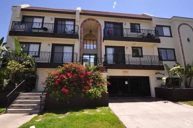
4499 Via Marisol Via Unit 115A
Los Angeles, CA 90042
Today
Favorites
323-326-3221
-
Bedrooms
2
-
Bathrooms
1
-
Square Feet
1,009 sq ft
-
Available
Available Mar 21
Highlight
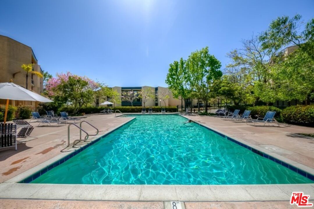
- Pool
4499 Via Marisol Via Unit 115A

Favorites
About This Home
$3,050 deposit,
Available Mar 21
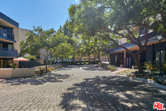
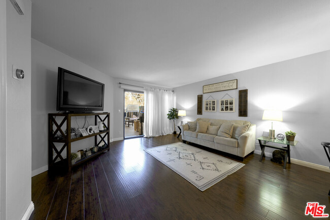
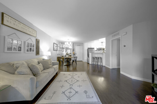
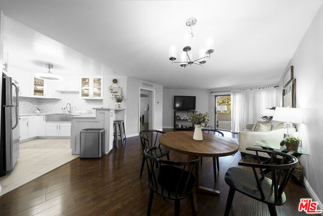
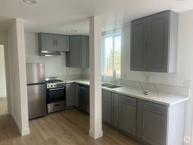
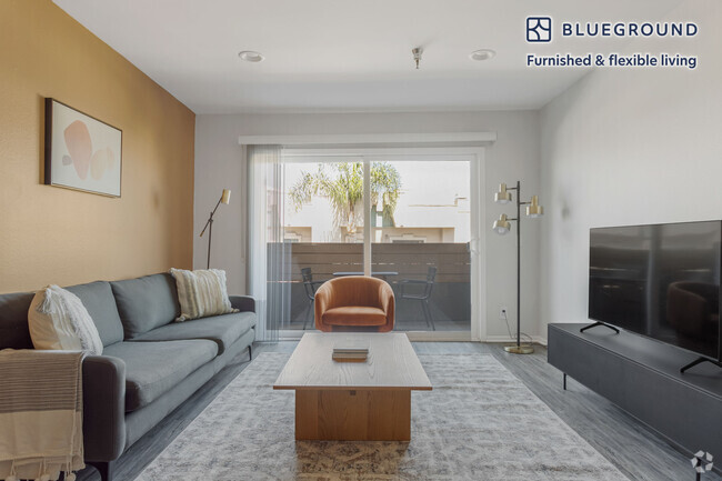
Beautiful 2-Bed, 1-Bath Condo in Montry Hills. Discover this stunning, fully renovated condo nestled in the desirable Montry Hills neighborhood. Featuring two spacious bedrooms and one modern bathroom, this unit offers comfort and style throughout. Step outside to a huge private patio perfect for relaxing or entertaining. The community is known for its friendly atmosphere and tree-lined streets, making it ideal for peaceful walks. Additional features include: Two dedicated parking spaces. Access to a large community swimming pool Conveniently located near Highway 110, South Pasadena, Downtown LA, and the USC Medical School. Experience the best of city living in a tranquil, welcoming neighborhood. Don't miss out on this gem!
4499 Via Marisol Via is a condo located in Los Angeles County and the 90042 ZIP Code.
* Price shown is base rent and may not include non-optional fees and utilities.
Price, availability, fees, and any applicable rent special are subject to change without notice.
* Square footage definitions vary. Displayed square footage is approximate.
Condo Features
Dishwasher
Washer/Dryer Hookup
Microwave
Refrigerator
- Washer/Dryer Hookup
- Dishwasher
- Microwave
- Refrigerator
- Views
- Pool
Contact
- Listed by Jin Seo | Redpoint Realty
- Phone Number (323) 326-3221
- Contact
-
Source
 MLS(TM)/CLAW
Copyright 2025 TheMLS/CLAW. All rights reserved. Information is deemed reliable but not guaranteed.
$3,284 / month
$400,000 Listing Price
2 Beds
•2 Baths
•
1,023 Sq Ft
$3,274 / month
$485,000 Listing Price
2 Beds
•1 Baths
•
800 Sq Ft
$3,121 / month
$439,000 Listing Price
2 Beds
•1 Baths
•
664 Sq Ft
Location
Get Directions
Amenities
- Washer/Dryer Hookup
- Dishwasher
- Microwave
- Refrigerator
- Views
- Pool
A quiet suburb outside of Los Angeles, Monterey Hills is known for its rolling hills, winding residential streets, and elevated city views. Check out Elephant Hill, a popular place to bike or hike that offers beautiful views of the neighborhood. Herman Park is nestled along Highway 110 in the north end of the neighborhood, offering tennis courts, playgrounds, and a dog park. And for more outdoor recreation, visit the biking paths and hiking trails at Ernest E. Debs Regional Park, bordering Monterey Hills.
Monterey Hills is a more secluded part of Northeast Los Angeles with larger lots, single-family homes, and tree-lined streets. However, if you cross over Highway 110, you’ll find theatres, restaurants, services, and more. Monterey Hills is located just seven miles northeast of Downtown Los Angeles and eight miles east of major attractions such as Griffith Park, the Los Angeles Zoo, the Greek Theatre, and Glendale Galleria.
Learn more about living in Monterey Hills
Education
| Colleges & Universities | Distance | ||
|---|---|---|---|
| Colleges & Universities | Distance | ||
| Drive: | 9 min | 3.7 mi | |
| Drive: | 8 min | 3.9 mi | |
| Drive: | 7 min | 4.1 mi | |
| Drive: | 11 min | 4.2 mi |
4499 Via Marisol Via Unit 115A is within 9 minutes or 3.7 miles from Occidental College. It is also near Cal State Los Angeles and Art Center College of Design.
Transportation options available in Los Angeles include Highland Park Station, located 1.5 miles from 4499 Via Marisol Via Unit 115A. 4499 Via Marisol Via Unit 115A is near Bob Hope, located 17.9 miles or 26 minutes away, and Los Angeles International, located 21.0 miles or 33 minutes away.
| Transit / Subway | Distance | ||
|---|---|---|---|
| Transit / Subway | Distance | ||
|
|
Drive: | 4 min | 1.5 mi |
|
|
Drive: | 6 min | 2.7 mi |
|
|
Drive: | 6 min | 3.0 mi |
|
|
Drive: | 5 min | 3.1 mi |
|
|
Drive: | 7 min | 3.7 mi |
| Commuter Rail | Distance | ||
|---|---|---|---|
| Commuter Rail | Distance | ||
|
|
Drive: | 11 min | 5.9 mi |
|
|
Drive: | 13 min | 6.0 mi |
|
|
Drive: | 12 min | 7.2 mi |
| Drive: | 15 min | 10.0 mi | |
|
|
Drive: | 21 min | 10.2 mi |
| Airports | Distance | ||
|---|---|---|---|
| Airports | Distance | ||
|
Bob Hope
|
Drive: | 26 min | 17.9 mi |
|
Los Angeles International
|
Drive: | 33 min | 21.0 mi |
Time and distance from 4499 Via Marisol Via Unit 115A.
| Shopping Centers | Distance | ||
|---|---|---|---|
| Shopping Centers | Distance | ||
| Drive: | 3 min | 1.3 mi | |
| Drive: | 4 min | 1.8 mi | |
| Drive: | 4 min | 2.0 mi |
4499 Via Marisol Via Unit 115A has 3 shopping centers within 2.0 miles, which is about a 4-minute drive. The miles and minutes will be for the farthest away property.
| Parks and Recreation | Distance | ||
|---|---|---|---|
| Parks and Recreation | Distance | ||
|
Audubon Center at Debs Park
|
Drive: | 4 min | 2.0 mi |
|
Chavez Ravine Arboretum
|
Drive: | 10 min | 5.7 mi |
|
Elysian Park
|
Drive: | 13 min | 5.7 mi |
|
Elyria Canyon Park
|
Drive: | 11 min | 6.0 mi |
|
Marsh Park
|
Drive: | 12 min | 6.3 mi |
4499 Via Marisol Via Unit 115A has 5 parks within 6.3 miles, including Audubon Center at Debs Park, Elyria Canyon Park, and Elysian Park.
| Hospitals | Distance | ||
|---|---|---|---|
| Hospitals | Distance | ||
| Drive: | 7 min | 3.6 mi | |
| Drive: | 9 min | 3.7 mi | |
| Drive: | 7 min | 4.5 mi |
4499 Via Marisol Via Unit 115A has 3 hospitals within 4.5 miles, the nearest is Keck Hospital of USC which is 3.6 miles away and a 7 minute drive.
| Military Bases | Distance | ||
|---|---|---|---|
| Military Bases | Distance | ||
| Drive: | 31 min | 22.6 mi | |
| Drive: | 42 min | 27.1 mi |
4499 Via Marisol Via Unit 115A is 22.6 miles from Los Angeles Air Force Base, and is convenient to other military bases, including Los Alamitos Army Airfield.
You May Also Like
Similar Rentals Nearby

What Are Walk Score®, Transit Score®, and Bike Score® Ratings?
Walk Score® measures the walkability of any address. Transit Score® measures access to public transit. Bike Score® measures the bikeability of any address.
What is a Sound Score Rating?
A Sound Score Rating aggregates noise caused by vehicle traffic, airplane traffic and local sources

4499 Via Marisol Via
Los Angeles, CA 90042