
$1,700 / Month
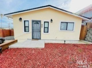
454 Carter St Unit A
Vallejo, CA 94590
Today
Favorites
707-334-7900
-
Bedrooms
3
-
Bathrooms
1
-
Square Feet
1,962 sq ft
-
Available
Available Now
Highlights
- Living Room with Attached Deck
- Landscaped
- 1-Story Property
454 Carter St Unit A

Favorites
About This Home
Available Now
Recently painted one bedroom with dedicated laundry on site. All appliances included and more, must see. Ready for new tenant. MLS#325034530
454 Carter St is an apartment community located in Solano County and the 94590 ZIP Code.
* Price shown is base rent and may not include non-optional fees and utilities.
Price, availability, fees, and any applicable rent special are subject to change without notice.
* Square footage definitions vary. Displayed square footage is approximate.
Home Details
Year Built
Built in 1955
Bedrooms and Bathrooms
1 Full Bathroom
3 Bedrooms
Home Design
Apartment
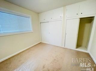
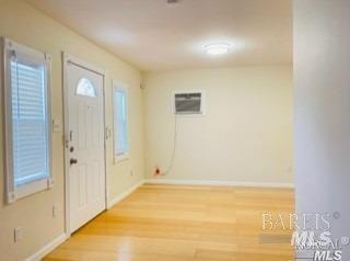
Interior Spaces
Living Room with Attached Deck
1,962 Sq Ft Home
1-Story Property
Laundry
Dryer
Washer
Listing and Financial Details
Security Deposit $1,750
Assessor Parcel Number 0051-182-240
Lot Details
5,502 Sq Ft Lot
Landscaped
Parking
No Garage
Utilities
Heating System Uses Natural Gas
Wall Furnace
Cooling System Mounted In Outer Wall Opening
Community Details
Contact
- Listed by Willie Jefferson | New City Realty
- Phone Number
- Contact
-
Source
 BAREIS MLS ®
Copyright 2025, Bay Area Real Estate Information Services, Inc. All Rights Reserved.
Location
Get Directions
Located about one mile northwest of the heart of Vallejo, Vallejo Heights is a tranquil neighborhood boasting rich diversity and sweeping views of the Napa River from its hilly landscape. Vallejo Heights is largely residential, offering an array of apartments and houses for rent in a beautiful locale.
Residents are typically drawn to the neighborhood’s natural beauty, scenic vistas, and overall peaceful atmosphere. Vallejo Heights contains numerous parks for the community to enjoy, including Terrace Park, Sheveland Park, and River Park. Vallejo Heights is also just a short drive from local attractions like Mare Island Naval Shipyard and Six Flags Discovery Kingdom, as well as Napa Wine Country and the San Francisco Bay Area.
Learn more about living in Vallejo Heights
Education
| Colleges & Universities | Distance | ||
|---|---|---|---|
| Colleges & Universities | Distance | ||
| Drive: | 9 min | 3.9 mi | |
| Drive: | 17 min | 11.9 mi | |
| Drive: | 20 min | 13.5 mi | |
| Drive: | 22 min | 15.1 mi |
454 Carter St Unit A is within 9 minutes or 3.9 miles from Touro University California. It is also near Napa Valley College and Solano Community College.
Transportation options available in Vallejo include El Cerrito Del Norte Station, located 18.3 miles from 454 Carter St Unit A. 454 Carter St Unit A is near Metro Oakland International, located 37.2 miles or 49 minutes away, and San Francisco International, located 44.8 miles or 61 minutes away.
| Transit / Subway | Distance | ||
|---|---|---|---|
| Transit / Subway | Distance | ||
|
|
Drive: | 25 min | 18.3 mi |
|
|
Drive: | 25 min | 18.5 mi |
|
|
Drive: | 27 min | 18.6 mi |
|
|
Drive: | 28 min | 19.1 mi |
|
|
Drive: | 27 min | 20.1 mi |
| Commuter Rail | Distance | ||
|---|---|---|---|
| Commuter Rail | Distance | ||
|
|
Drive: | 20 min | 13.6 mi |
|
|
Drive: | 23 min | 17.5 mi |
| Drive: | 29 min | 20.1 mi | |
| Drive: | 30 min | 21.6 mi | |
| Drive: | 31 min | 21.8 mi |
| Airports | Distance | ||
|---|---|---|---|
| Airports | Distance | ||
|
Metro Oakland International
|
Drive: | 49 min | 37.2 mi |
|
San Francisco International
|
Drive: | 61 min | 44.8 mi |
Time and distance from 454 Carter St Unit A.
| Shopping Centers | Distance | ||
|---|---|---|---|
| Shopping Centers | Distance | ||
| Walk: | 13 min | 0.7 mi | |
| Walk: | 16 min | 0.8 mi | |
| Walk: | 17 min | 0.9 mi |
454 Carter St Unit A has 3 shopping centers within 0.9 mile, which is about a 17-minute walk. The miles and minutes will be for the farthest away property.
| Parks and Recreation | Distance | ||
|---|---|---|---|
| Parks and Recreation | Distance | ||
|
Dan Foley Park
|
Drive: | 6 min | 2.6 mi |
|
Six Flags Discovery Kingdom
|
Drive: | 7 min | 3.8 mi |
|
Benicia State Recreation Area
|
Drive: | 12 min | 6.4 mi |
|
Crockett Hills Regional Park
|
Drive: | 11 min | 6.9 mi |
|
Carquinez Strait Regional Shoreline
|
Drive: | 16 min | 9.1 mi |
454 Carter St Unit A has 5 parks within 9.1 miles, including Dan Foley Park, Six Flags Discovery Kingdom, and Benicia State Recreation Area.
| Hospitals | Distance | ||
|---|---|---|---|
| Hospitals | Distance | ||
| Drive: | 3 min | 1.1 mi | |
| Drive: | 4 min | 1.8 mi | |
| Drive: | 6 min | 2.5 mi |
454 Carter St Unit A has 3 hospitals within 2.5 miles, the nearest is Adventist Health Vallejo which is 1.1 miles away and a 3 minute drive.
| Military Bases | Distance | ||
|---|---|---|---|
| Military Bases | Distance | ||
| Drive: | 7 min | 3.4 mi | |
| Drive: | 16 min | 10.3 mi |
454 Carter St Unit A is 3.4 miles from Mare Island Naval Reserve, and is convenient to other military bases, including Armory Vallejo.
You May Also Like
Similar Rentals Nearby


What Are Walk Score®, Transit Score®, and Bike Score® Ratings?
Walk Score® measures the walkability of any address. Transit Score® measures access to public transit. Bike Score® measures the bikeability of any address.
What is a Sound Score Rating?
A Sound Score Rating aggregates noise caused by vehicle traffic, airplane traffic and local sources
454 Carter St
Vallejo, CA 94590