4727 Sand Point Way NE
Seattle, WA 98105
-
Bedrooms
3
-
Bathrooms
1.5
-
Square Feet
1,324 sq ft
-
Available
Available Now
Highlights
- Pets Allowed
- Hardwood Floors
- Fenced Lot

About This Home
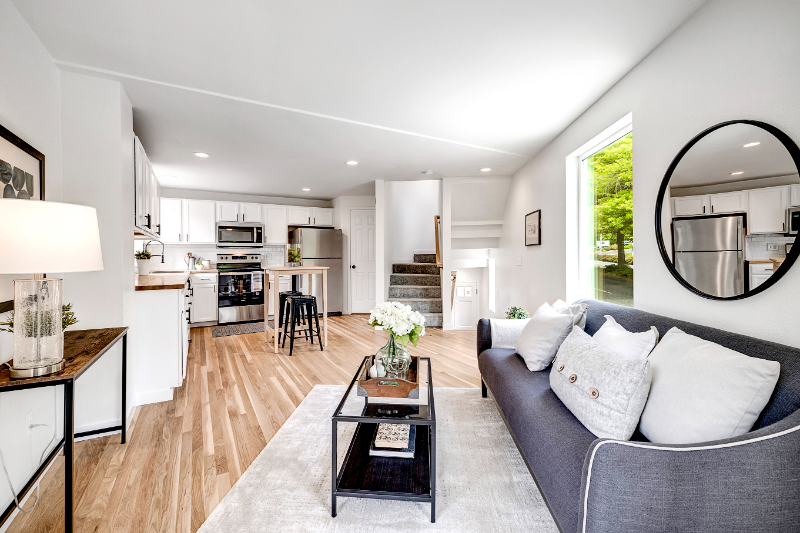
Property Id: 1437607 Description Seattle Children's Hospital Home - 3Bed/1.5Bath with Terrace, A/C & Heating Right across Seattle Children's Hospital , close to UW, Burke-Gilman Trail & Restaurants - safe neighborhood. Utilities: Not included, tenant pays utilities Parking: One reserved parking spot in front of the home. *Excellent public transit access CLOSEST HOSPITALS: Seattle Children's - Across the home UW Medicine - 1.5miles Note: Renter is responsible for all utilities (gas, electricity, internet, water/Sewer & garbage). First month rent, Last month's rent & security deposit due at signing. One year or longer lease. Small pets (up to 20 pounds) permitted. (Pets fees/deposit apply) No smoking allowed. Don't miss out on this opportunity to secure a wonderful home in Laurelhurst/The University of Washington neighborhood. Thanks!
4727 Sand Point Way NE is a house located in King County and the 98105 ZIP Code. This area is served by the Seattle Public Schools attendance zone.
House Features
Washer/Dryer
Dishwasher
Hardwood Floors
Microwave
- Washer/Dryer
- Dishwasher
- Disposal
- Microwave
- Oven
- Refrigerator
- Hardwood Floors
- Bicycle Storage
- Fenced Lot
Contact
- Phone Number
- Contact
-
Source

- Washer/Dryer
- Dishwasher
- Disposal
- Microwave
- Oven
- Refrigerator
- Hardwood Floors
- Fenced Lot
- Bicycle Storage
Nestled between Ravenna and View Ridge, Bryant is a mostly residential neighborhood teeming with apartments, townhomes, and condos available for rent in northeast Seattle. Bryant exudes a peaceful atmosphere, with plenty of charming homes tucked along tree-dense avenues.
Bryant is known for its family-friendly vibe, offering quick access to Burke-Gilman Playground Park as well as Seattle Children’s Hospital. This tranquil neighborhood sits just northeast of the University of Washington, making it a top choice for many students, faculty, and staff. Residents also enjoy great shopping and dining options at the nearby University Village, which is easily accessible via the Burke-Gilman Trail.
Learn more about living in Bryant| Colleges & Universities | Distance | ||
|---|---|---|---|
| Colleges & Universities | Distance | ||
| Drive: | 4 min | 1.3 mi | |
| Drive: | 14 min | 4.6 mi | |
| Drive: | 13 min | 5.1 mi | |
| Drive: | 11 min | 5.2 mi |


View GreatSchools Rating Methodology
Transportation options available in Seattle include U District Station, located 1.7 miles from 4727 Sand Point Way NE. 4727 Sand Point Way NE is near Seattle-Tacoma International, located 19.4 miles or 31 minutes away, and Seattle Paine Field International, located 21.5 miles or 34 minutes away.
| Transit / Subway | Distance | ||
|---|---|---|---|
| Transit / Subway | Distance | ||
| Drive: | 5 min | 1.7 mi | |
| Drive: | 5 min | 1.8 mi | |
| Drive: | 7 min | 2.3 mi | |
|
|
Drive: | 9 min | 4.5 mi |
| Drive: | 11 min | 5.4 mi |
| Commuter Rail | Distance | ||
|---|---|---|---|
| Commuter Rail | Distance | ||
|
|
Drive: | 13 min | 6.2 mi |
|
|
Drive: | 27 min | 15.3 mi |
|
|
Drive: | 27 min | 17.9 mi |
|
|
Drive: | 36 min | 23.6 mi |
|
|
Drive: | 39 min | 24.4 mi |
| Airports | Distance | ||
|---|---|---|---|
| Airports | Distance | ||
|
Seattle-Tacoma International
|
Drive: | 31 min | 19.4 mi |
|
Seattle Paine Field International
|
Drive: | 34 min | 21.5 mi |
Time and distance from 4727 Sand Point Way NE.
| Shopping Centers | Distance | ||
|---|---|---|---|
| Shopping Centers | Distance | ||
| Walk: | 16 min | 0.9 mi | |
| Drive: | 4 min | 1.6 mi | |
| Drive: | 5 min | 1.7 mi |
| Parks and Recreation | Distance | ||
|---|---|---|---|
| Parks and Recreation | Distance | ||
|
UW Botanic Gardens
|
Walk: | 10 min | 0.5 mi |
|
Burke Museum of Natural History
|
Drive: | 4 min | 1.4 mi |
|
University of Washington Fish Collection
|
Drive: | 4 min | 1.5 mi |
|
Cowen Park
|
Drive: | 5 min | 1.9 mi |
|
Ravenna Park
|
Drive: | 6 min | 2.1 mi |
| Hospitals | Distance | ||
|---|---|---|---|
| Hospitals | Distance | ||
| Walk: | 1 min | 0.1 mi | |
| Drive: | 4 min | 1.8 mi | |
| Drive: | 12 min | 4.2 mi |
| Military Bases | Distance | ||
|---|---|---|---|
| Military Bases | Distance | ||
| Drive: | 24 min | 7.5 mi | |
| Drive: | 84 min | 36.6 mi |
You May Also Like
What Are Walk Score®, Transit Score®, and Bike Score® Ratings?
Walk Score® measures the walkability of any address. Transit Score® measures access to public transit. Bike Score® measures the bikeability of any address.
What is a Sound Score Rating?
A Sound Score Rating aggregates noise caused by vehicle traffic, airplane traffic and local sources

4727 Sand Point Way NE
Seattle, WA 98105