-
Monthly Rent
$3,475
-
Bedrooms
2 bd
-
Bathrooms
1.5 ba
-
Square Feet
1,000 sq ft
Details

48 Wenham St is an apartment community located in Suffolk County and the 02130 ZIP Code. This area is served by the Boston Public Schools attendance zone.
Contact
Apartment Features
- Washer/Dryer
Fees and Policies
The fees below are based on community-supplied data and may exclude additional fees and utilities.
Details
Property Information
-
4 units
Situated seven miles southwest of downtown Boston, Forest Hills-Woodbourne in Jamaica Plain is a mostly residential neighborhood of multi-family homes for rent. Large green spaces cover much of the neighborhood, with the Woodbourne historical district consisting of houses dating back to the 19th century. Residents walk to the Forest Hills subway station on the Orange Line to head into downtown. This station also acts as a hub for many bus lines to take locals to other parts of the city and is home to a small business area.
The Arnold Arboretum covers a large portion of this neighborhood, and many locals wander the landscape paths, go bird watching, or relax under the maple trees. For a hearty breakfast, walk over to the Forest Hills Diner for eggs and home fries. Brassica Kitchen and Cafe serves up a tasting menu of pork belly and seaweed tagliatelle along with creative cocktails. After dinner, settle in a Eugene O'Neill's to watch the game.
Learn more about living in Forest Hills-Woodbourne| Colleges & Universities | Distance | ||
|---|---|---|---|
| Colleges & Universities | Distance | ||
| Drive: | 6 min | 3.2 mi | |
| Drive: | 7 min | 3.7 mi | |
| Drive: | 7 min | 3.8 mi | |
| Drive: | 9 min | 4.5 mi |
Transportation options available in Boston include Forest Hills Station, located 0.3 mile from 48 Wenham St Unit 1. 48 Wenham St Unit 1 is near General Edward Lawrence Logan International, located 8.5 miles or 17 minutes away.
| Transit / Subway | Distance | ||
|---|---|---|---|
| Transit / Subway | Distance | ||
|
|
Walk: | 6 min | 0.3 mi |
|
|
Drive: | 2 min | 1.2 mi |
|
|
Drive: | 4 min | 1.7 mi |
|
|
Drive: | 4 min | 2.1 mi |
|
|
Drive: | 7 min | 2.4 mi |
| Commuter Rail | Distance | ||
|---|---|---|---|
| Commuter Rail | Distance | ||
|
|
Walk: | 6 min | 0.3 mi |
|
|
Drive: | 5 min | 1.7 mi |
|
|
Drive: | 7 min | 2.4 mi |
|
|
Drive: | 4 min | 2.5 mi |
| Drive: | 6 min | 3.1 mi |
| Airports | Distance | ||
|---|---|---|---|
| Airports | Distance | ||
|
General Edward Lawrence Logan International
|
Drive: | 17 min | 8.5 mi |
Time and distance from 48 Wenham St Unit 1.
| Shopping Centers | Distance | ||
|---|---|---|---|
| Shopping Centers | Distance | ||
| Drive: | 4 min | 1.5 mi | |
| Drive: | 4 min | 2.0 mi | |
| Drive: | 5 min | 2.5 mi |
| Parks and Recreation | Distance | ||
|---|---|---|---|
| Parks and Recreation | Distance | ||
|
Mass Audubon's Boston Nature Center and Wildlife Sanctuary
|
Drive: | 5 min | 1.6 mi |
|
Franklin Park Zoo
|
Drive: | 5 min | 2.2 mi |
|
Arnold Arboretum of Harvard University
|
Drive: | 4 min | 2.3 mi |
|
Lower Neponset River Trail
|
Drive: | 5 min | 2.3 mi |
|
Frederick Law Olmsted National Historic Site
|
Drive: | 7 min | 3.2 mi |
| Hospitals | Distance | ||
|---|---|---|---|
| Hospitals | Distance | ||
| Drive: | 3 min | 1.9 mi | |
| Drive: | 7 min | 3.2 mi | |
| Drive: | 7 min | 3.5 mi |
| Military Bases | Distance | ||
|---|---|---|---|
| Military Bases | Distance | ||
| Drive: | 28 min | 16.3 mi |
- Washer/Dryer
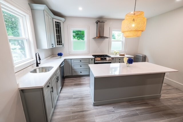
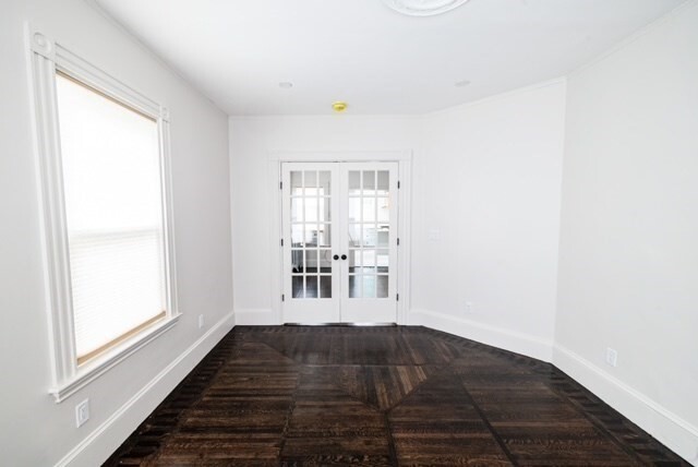
48 Wenham St Unit 1 Photos
What Are Walk Score®, Transit Score®, and Bike Score® Ratings?
Walk Score® measures the walkability of any address. Transit Score® measures access to public transit. Bike Score® measures the bikeability of any address.
What is a Sound Score Rating?
A Sound Score Rating aggregates noise caused by vehicle traffic, airplane traffic and local sources


