
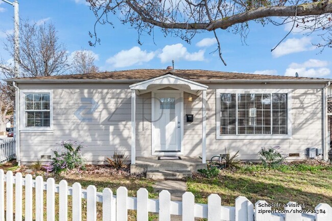
$3,950 / Month
480 Sequoia Ave
Redwood City, CA 94061
Today
Favorites
-
Bedrooms
2
-
Bathrooms
1
-
Square Feet
1,010 sq ft
-
Available
Available Now
480 Sequoia Ave

Favorites
About This Home
Available Now
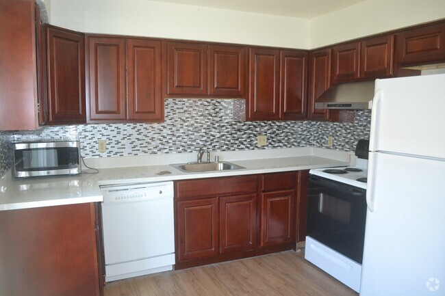
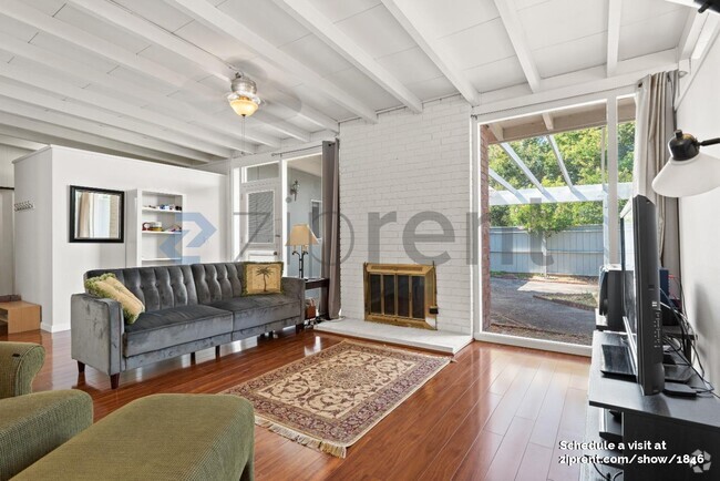
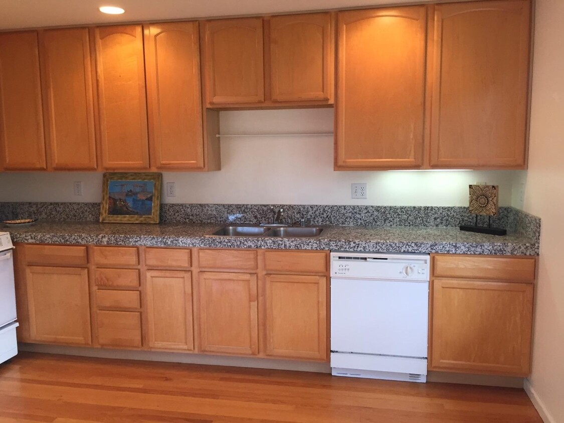
Great location. Well appointed and bright. Gourmet kitchen with granite counters, gas stove with built-in microwave. Double pane windows, high ceilings, hardwood floor and carpeting. Lots of natural light. Close to all comforts. High speed internet available. Bike to Palo Alto, Stanford, Menlo Park etc. Safe neighborhood. Serious enquiries Clean. Great location. Stroll through multi-million dollar homes of Atherton. Laundry facilities inside. Ideal for Stanford Hospital Residents and Fellows. Just mins away from Stanford and all major companies like Apple, SAP, Oracle, Tesla, Facebook, Google, etc. NS/NP. Will consider small dog or cat. Two year lease preferred. Will consider 12 months too. When responding, please tell us little bit about yourself, who all will be living here, timing and lease term preference. Min. FICO required 700
480 Sequoia Ave is a house located in San Mateo County and the 94061 ZIP Code. This area is served by the Redwood City Elementary attendance zone.
* Price shown is base rent and may not include non-optional fees and utilities.
Price, availability, fees, and any applicable rent special are subject to change without notice.
* Square footage definitions vary. Displayed square footage is approximate.
Home Details
Home Type
Single Family Detached Home
Bedrooms and Bathrooms
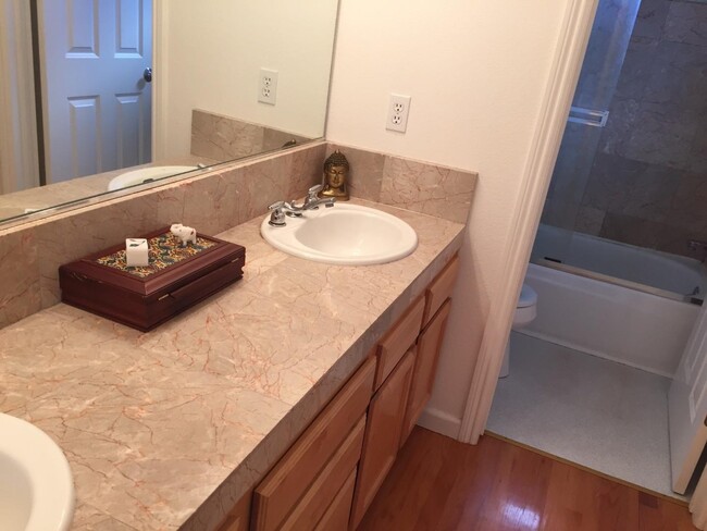
1 Full Bathroom
2 Bedrooms
Flooring
Wood
Carpet
Interior Spaces
Dining Area
1,010 Sq Ft Home
Kitchen
Electric Oven
Gas Cooktop
Microwave
Dishwasher
Laundry
Washer and Dryer
Listing and Financial Details
Property Available on 6/1/25
12-Month Minimum Lease Term
Rent includes sewer
Utilities
Forced Air Heating System
Community Details
Contact
- Listed by Sam Jasu | E.R.E. Enterprise
- Contact
-
Source
 MLSListings Inc.
Copyright © 2025 MLSListings Inc.
Location
Get Directions
With an average of 255 sunny days per year, Redwood City is a classic sunny California city. Aside from its exceptional climate, Redwood City is known for being a technology hub as it sits in the heart of Silicon Valley. Several technology companies such as Oracle, YaSheng Group, Electronic Arts, and Shutterfly call Redwood City home. Redwood City is also home to Port of Redwood City, the only active deep-water port in the South San Francisco Bay. Accessible to the Caltrain commuter rail, major roadways, and the San Francisco and San Jose International Airports, Redwood City is also ideal for commuters.
Head to the vibrant downtown area for a range of entertainment options. Downtown Redwood City contains numerous shops and tasty restaurants as well as historic landmarks and museums like the historic Fox Theatre, San Mateo County History Museum, and Pulgas Water Temple.
Learn more about living in Redwood City
Education
| Colleges & Universities | Distance | ||
|---|---|---|---|
| Colleges & Universities | Distance | ||
| Drive: | 8 min | 2.3 mi | |
| Drive: | 9 min | 3.8 mi | |
| Drive: | 15 min | 5.0 mi | |
| Drive: | 20 min | 11.7 mi |
480 Sequoia Ave is within 8 minutes or 2.3 miles from Menlo College. It is also near Canada College and Stanford University.
Schools


Public Elementary School
Grades K-5
367 Students
Nearby
Public Elementary School
Grades K-5
448 Students
Attendance Zone
Public Middle School
Grades 6-8
706 Students
Attendance Zone
Public High School
Grades 9-12
1,694 Students
Attendance Zone
Private Elementary, Middle & High School
Grades PK-12
Nearby
Private Elementary & Middle School
Grades PK-8
319 Students
Nearby
Private Middle & High School
Grades 8-12
Nearby
School data provided by
 The GreatSchools Rating helps parents compare schools within a state based on a variety of school quality indicators and provides a helpful picture of how effectively each school serves all of its students. Ratings are on a scale of 1 (below average) to 10 (above average) and can include test scores, college readiness, academic progress, advanced courses, equity, discipline and attendance data. We also advise parents to visit schools, consider other information on school performance and programs, and consider family needs as part of the school selection process.
View GreatSchools Rating Methodology
View GreatSchools Rating Methodology
Transportation options available in Redwood City include Bayshore/Nasa Station, located 14.2 miles from 480 Sequoia Ave. 480 Sequoia Ave is near San Francisco International, located 17.6 miles or 27 minutes away, and Norman Y Mineta San Jose International, located 21.6 miles or 31 minutes away.
| Transit / Subway | Distance | ||
|---|---|---|---|
| Transit / Subway | Distance | ||
|
|
Drive: | 21 min | 14.2 mi |
|
|
Drive: | 21 min | 14.5 mi |
|
|
Drive: | 22 min | 14.6 mi |
|
|
Drive: | 22 min | 14.7 mi |
|
|
Drive: | 22 min | 15.0 mi |
| Commuter Rail | Distance | ||
|---|---|---|---|
| Commuter Rail | Distance | ||
| Drive: | 8 min | 3.1 mi | |
| Drive: | 9 min | 3.2 mi | |
| Drive: | 11 min | 4.4 mi | |
| Drive: | 13 min | 5.3 mi | |
| Drive: | 15 min | 6.2 mi |
| Airports | Distance | ||
|---|---|---|---|
| Airports | Distance | ||
|
San Francisco International
|
Drive: | 27 min | 17.6 mi |
|
Norman Y Mineta San Jose International
|
Drive: | 31 min | 21.6 mi |
Time and distance from 480 Sequoia Ave.
| Shopping Centers | Distance | ||
|---|---|---|---|
| Shopping Centers | Distance | ||
| Walk: | 9 min | 0.5 mi | |
| Drive: | 4 min | 1.3 mi | |
| Drive: | 4 min | 1.6 mi |
480 Sequoia Ave has 3 shopping centers within 1.6 miles, which is about a 4-minute walk. The miles and minutes will be for the farthest away property.
| Parks and Recreation | Distance | ||
|---|---|---|---|
| Parks and Recreation | Distance | ||
|
Sharon Hills Park
|
Drive: | 6 min | 2.1 mi |
|
Red Morton Park
|
Drive: | 7 min | 2.1 mi |
|
Stulsaft Park
|
Drive: | 7 min | 2.4 mi |
|
Holbrook-Palmer Park
|
Drive: | 8 min | 2.8 mi |
|
Sharon Park
|
Drive: | 8 min | 2.9 mi |
480 Sequoia Ave has 5 parks within 2.9 miles, including Stulsaft Park, Red Morton Park, and Sharon Hills Park.
| Hospitals | Distance | ||
|---|---|---|---|
| Hospitals | Distance | ||
| Drive: | 9 min | 3.0 mi | |
| Drive: | 8 min | 3.2 mi | |
| Drive: | 11 min | 4.2 mi |
480 Sequoia Ave has 3 hospitals within 4.2 miles, the nearest is Sequoia Hospital which is 3.0 miles away and a 9 minute drive.
| Military Bases | Distance | ||
|---|---|---|---|
| Military Bases | Distance | ||
| Drive: | 24 min | 14.5 mi |
480 Sequoia Ave is 14.5 miles and a 24 minute drive from Ames Research Center.
You May Also Like
Similar Rentals Nearby

What Are Walk Score®, Transit Score®, and Bike Score® Ratings?
Walk Score® measures the walkability of any address. Transit Score® measures access to public transit. Bike Score® measures the bikeability of any address.
What is a Sound Score Rating?
A Sound Score Rating aggregates noise caused by vehicle traffic, airplane traffic and local sources
480 Sequoia Ave
Redwood City, CA 94061