-
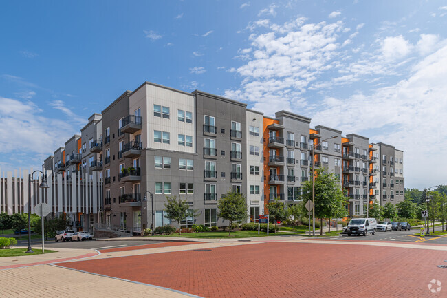
2 family house
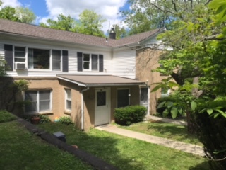
5 Fox Hill Rd
5 Fox Hill Rd,
Mahopac,
NY
10541
2 Weeks Ago
Favorites
5 Fox Hill Rd

Favorites
Check Back Soon for Upcoming Availability
About 5 Fox Hill Rd Mahopac, NY 10541
3 bedroom apartment in two family house. Living room with working fireplace, full size washer and dryer in family room, updated bathroom, huge yard, AWARD WINNING SCHOOLS. Please call as opposed to texting 914 299 6379
5 Fox Hill Rd is an apartment community located in Putnam County and the 10541 ZIP Code.
Apartment Features
- Smoke Free
- Wheelchair Accessible (Rooms)
Fees and Policies
The fees below are based on community-supplied data and may exclude additional fees and utilities.
Details
Lease Options
-
12 Months
Location
Get Directions
Amenities
- Smoke Free
- Wheelchair Accessible (Rooms)
Education
| Colleges & Universities | Distance | ||
|---|---|---|---|
| Colleges & Universities | Distance | ||
| Drive: | 31 min | 15.4 mi | |
| Drive: | 33 min | 18.3 mi | |
| Drive: | 35 min | 18.4 mi | |
| Drive: | 49 min | 24.3 mi |
5 Fox Hill Rd is within 31 minutes or 15.4 miles from Western Connecticut, Westside. It is also near Western Connecticut, Midtown and Pace University, Briarcliff.
Transportation options available in Mahopac include Eastchester-Dyre Ave, located 38.2 miles from 5 Fox Hill Rd. 5 Fox Hill Rd is near Westchester County, located 22.6 miles or 38 minutes away, and New York Stewart International, located 41.6 miles or 66 minutes away.
| Transit / Subway | Distance | ||
|---|---|---|---|
| Transit / Subway | Distance | ||
|
|
Drive: | 59 min | 38.2 mi |
|
|
Drive: | 58 min | 39.7 mi |
|
|
Drive: | 59 min | 40.1 mi |
|
|
Drive: | 60 min | 40.6 mi |
|
|
Drive: | 60 min | 41.0 mi |
| Commuter Rail | Distance | ||
|---|---|---|---|
| Commuter Rail | Distance | ||
|
|
Drive: | 11 min | 3.6 mi |
|
|
Drive: | 16 min | 5.8 mi |
|
|
Drive: | 17 min | 7.1 mi |
|
|
Drive: | 17 min | 7.3 mi |
|
|
Drive: | 28 min | 11.8 mi |
| Airports | Distance | ||
|---|---|---|---|
| Airports | Distance | ||
|
Westchester County
|
Drive: | 38 min | 22.6 mi |
|
New York Stewart International
|
Drive: | 66 min | 41.6 mi |
Time and distance from 5 Fox Hill Rd.
| Shopping Centers | Distance | ||
|---|---|---|---|
| Shopping Centers | Distance | ||
| Drive: | 10 min | 2.5 mi | |
| Drive: | 9 min | 2.6 mi | |
| Drive: | 10 min | 2.7 mi |
5 Fox Hill Rd has 3 shopping centers within 2.7 miles, which is about a 10-minute drive. The miles and minutes will be for the farthest away property.
| Parks and Recreation | Distance | ||
|---|---|---|---|
| Parks and Recreation | Distance | ||
|
Chamber of Commerce Park
|
Drive: | 9 min | 2.5 mi |
|
Danner Family Preserve
|
Drive: | 17 min | 6.5 mi |
|
Muscoot Farm
|
Drive: | 17 min | 7.5 mi |
|
Lasdon Park and Arboretum
|
Drive: | 20 min | 8.5 mi |
|
Hammond Museum & Japanese Stroll Garden
|
Drive: | 23 min | 9.8 mi |
5 Fox Hill Rd has 5 parks within 9.8 miles, including Chamber of Commerce Park, Danner Family Preserve, and Lasdon Park and Arboretum.
| Hospitals | Distance | ||
|---|---|---|---|
| Hospitals | Distance | ||
| Drive: | 15 min | 5.2 mi | |
| Drive: | 23 min | 11.3 mi |
5 Fox Hill Rd is 5.2 miles from Putnam Hospital Center, and is convenient to other hospitals, including Four Winds.
| Military Bases | Distance | ||
|---|---|---|---|
| Military Bases | Distance | ||
| Drive: | 31 min | 15.6 mi | |
| Drive: | 53 min | 26.2 mi |
5 Fox Hill Rd is 15.6 miles from Camp Smith NY State Military, and is convenient to other military bases, including West Point Military Reserve.
You May Also Like
Similar Rentals Nearby


What Are Walk Score®, Transit Score®, and Bike Score® Ratings?
Walk Score® measures the walkability of any address. Transit Score® measures access to public transit. Bike Score® measures the bikeability of any address.
What is a Sound Score Rating?
A Sound Score Rating aggregates noise caused by vehicle traffic, airplane traffic and local sources