
$2,750 / Month
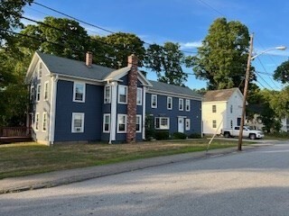
50 Central St Unit A
Southborough, MA 01745
2 Weeks Ago
Favorites
50 Central St Unit A

Favorites
Check Back Soon for Upcoming Availability
| Beds | Baths | Average SF |
|---|---|---|
| 2 Bedrooms 2 Bedrooms 2 Br | 1.5 Baths 1.5 Baths 1.5 Ba | — |
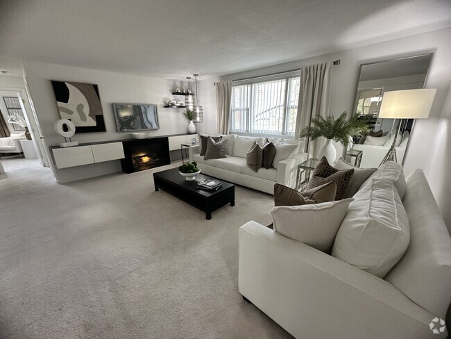
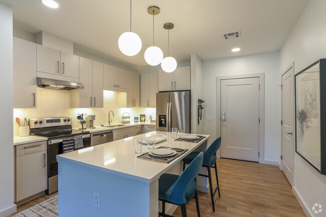
About This Property
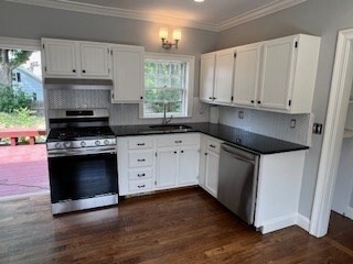
You will fall in love with this Stunning first floor unit with gorgeous renovation! Spacious and large unit with 2 BR's and home office! Open Country Kitchen with Hardwood flooring,Granite counters and direct access to beautiful yard with deck perfect for summertime BBQ's! Large Family room with tons of natural sunlight,built ins and Hardwoods! Gorgeous new Full Bath completely renovated with Tile surround Tub/shower! Extra half bath also beautifully renovated! Laundry in unit with washer dryer provided! You won't believe this yard! 2 parking spots on side street! Best of all...beautiful water views across street with stunning sunsets! Work from home in your quaint home office! Southborough has amazing schools,great access for commuters with train and highway close by! Tenant responsible for snow removal.
50 Central St is an apartment community located in Worcester County and the 01745 ZIP Code.
Location
Get Directions
Situated just moments east of Worcester is the Route 9 Corridor, a large neighborhood compiled of several communities including Shrewsbury, Westborough, Northborough, and Southborough. Not only is Worcester at residents’ fingertips, but Downtown Boston is less than 40 miles east. The Route 9 Corridor is a commuter’s dream, offering easy city access and entry onto Interstates 290, 495, and 90.
The suburb is dotted with ponds, reservoirs, brooks, and rivers, providing ample outdoor recreation. Renters craving a beach day can bask on the sunny shores of Lake Chauncy Beach. Route 9 Corridor’s Prospect Park allows locals to take their dog for a stroll while Assabet Park gives children ample space to play on the playground. Those looking for winter recreation won’t want to miss the powdery slopes of Ski Ward Ski Area. No matter the season, renters settling in this diverse community can choose from gorgeous apartments ranging in price and amenities.
Learn more about living in Route 9 CorridorBelow are rent ranges for similar nearby apartments
| Beds | Average Size | Lowest | Typical | Premium |
|---|---|---|---|---|
| Studio Studio Studio | 514 Sq Ft | $1,829 | $2,419 | $4,115 |
| 1 Bed 1 Bed 1 Bed | 796-797 Sq Ft | $1,200 | $2,925 | $7,272 |
| 2 Beds 2 Beds 2 Beds | 1155-1156 Sq Ft | $1,975 | $3,657 | $6,915 |
| 3 Beds 3 Beds 3 Beds | 1496 Sq Ft | $2,200 | $4,689 | $11,073 |
| 4 Beds 4 Beds 4 Beds | 2122 Sq Ft | $3,075 | $4,256 | $4,950 |
Education
| Colleges & Universities | Distance | ||
|---|---|---|---|
| Colleges & Universities | Distance | ||
| Drive: | 7 min | 4.0 mi | |
| Drive: | 21 min | 10.9 mi | |
| Drive: | 23 min | 12.4 mi | |
| Drive: | 23 min | 13.3 mi |
50 Central St Unit A is within 7 minutes or 4.0 miles from Framingham State College. It is also near Tufts University, Grafton and Wellesley College.
Transportation options available in Southborough include Riverside Station, located 15.8 miles from 50 Central St Unit A. 50 Central St Unit A is near Worcester Regional, located 20.6 miles or 35 minutes away, and General Edward Lawrence Logan International, located 28.9 miles or 40 minutes away.
| Transit / Subway | Distance | ||
|---|---|---|---|
| Transit / Subway | Distance | ||
|
|
Drive: | 22 min | 15.8 mi |
|
|
Drive: | 22 min | 16.1 mi |
|
|
Drive: | 24 min | 16.8 mi |
|
|
Drive: | 26 min | 18.4 mi |
|
|
Drive: | 26 min | 18.6 mi |
| Commuter Rail | Distance | ||
|---|---|---|---|
| Commuter Rail | Distance | ||
|
|
Drive: | 6 min | 2.5 mi |
|
|
Drive: | 14 min | 5.4 mi |
|
|
Drive: | 12 min | 5.9 mi |
|
|
Drive: | 12 min | 6.0 mi |
|
|
Drive: | 15 min | 7.2 mi |
| Airports | Distance | ||
|---|---|---|---|
| Airports | Distance | ||
|
Worcester Regional
|
Drive: | 35 min | 20.6 mi |
|
General Edward Lawrence Logan International
|
Drive: | 40 min | 28.9 mi |
Time and distance from 50 Central St Unit A.
| Shopping Centers | Distance | ||
|---|---|---|---|
| Shopping Centers | Distance | ||
| Drive: | 3 min | 1.4 mi | |
| Drive: | 4 min | 1.8 mi | |
| Drive: | 6 min | 3.3 mi |
50 Central St Unit A has 3 shopping centers within 3.3 miles, which is about a 6-minute drive. The miles and minutes will be for the farthest away property.
| Parks and Recreation | Distance | ||
|---|---|---|---|
| Parks and Recreation | Distance | ||
|
Wilfred J. Turenne Wildlife Habitat
|
Walk: | 12 min | 0.6 mi |
|
Cowassock Woods and Ashland Town Forest
|
Drive: | 5 min | 2.4 mi |
|
Callahan State Park
|
Drive: | 8 min | 3.9 mi |
|
Hopkinton State Park
|
Drive: | 15 min | 4.2 mi |
|
Hop Brook Natural Area
|
Drive: | 10 min | 5.0 mi |
50 Central St Unit A has 5 parks within 5.0 miles, including Wilfred J. Turenne Wildlife Habitat, Cowassock Woods and Ashland Town Forest, and Hopkinton State Park.
| Hospitals | Distance | ||
|---|---|---|---|
| Hospitals | Distance | ||
| Drive: | 10 min | 5.1 mi | |
| Drive: | 10 min | 5.3 mi |
50 Central St Unit A is 5.1 miles from UMass Memorial Healthcare - Marlborough Hospital, and is convenient to other hospitals, including MetroWest Medical Center.
| Military Bases | Distance | ||
|---|---|---|---|
| Military Bases | Distance | ||
| Drive: | 15 min | 8.7 mi |
50 Central St Unit A is 8.7 miles and a 15 minute drive from US Military Reservation.
You May Also Like
Similar Rentals Nearby


What Are Walk Score®, Transit Score®, and Bike Score® Ratings?
Walk Score® measures the walkability of any address. Transit Score® measures access to public transit. Bike Score® measures the bikeability of any address.
What is a Sound Score Rating?
A Sound Score Rating aggregates noise caused by vehicle traffic, airplane traffic and local sources
50 Central St
Southborough, MA 01745