
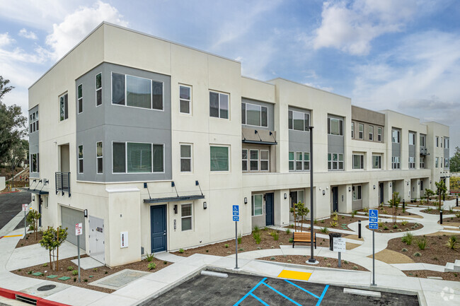
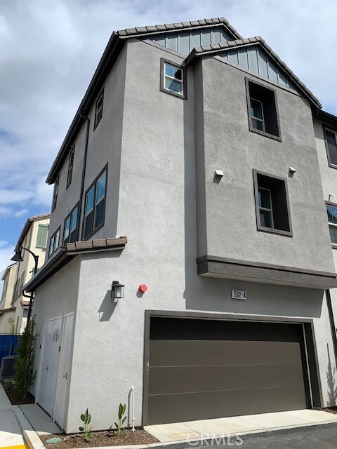
502 Tamarind Way
West Covina, CA 91791
Favorites

502 Tamarind Way
Favorites
Check Back Soon for Upcoming Availability
| Beds | Baths | Average SF |
|---|---|---|
| 2 Bedrooms 2 Bedrooms 2 Br | 3 Baths 3 Baths 3 Ba | 1,585 SF |
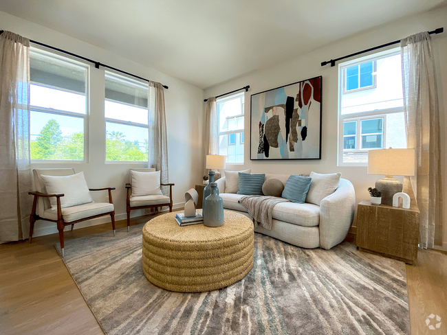
About This Property
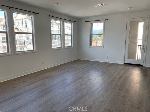
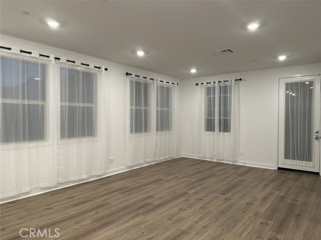
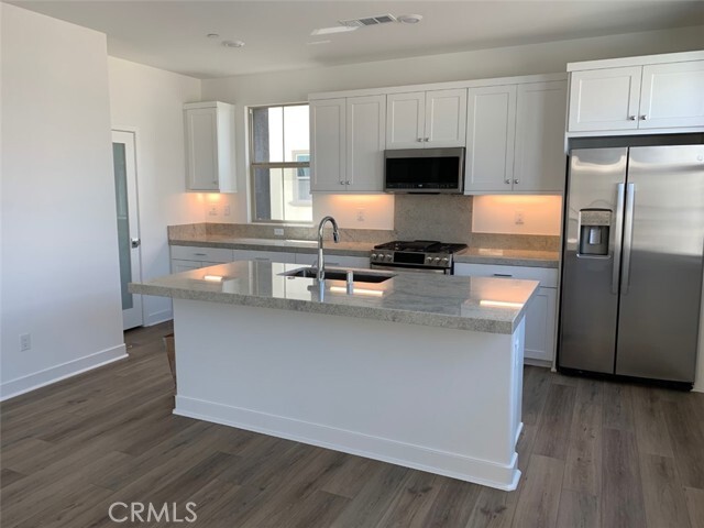
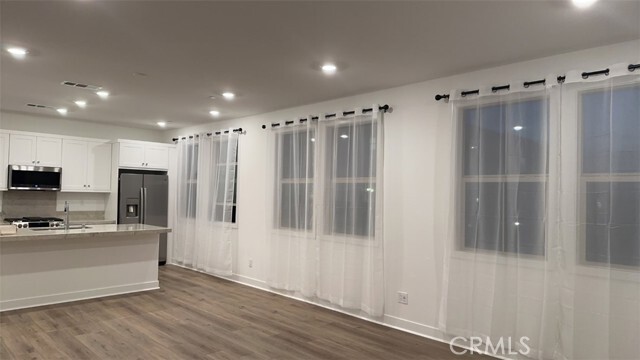
Brand new developed community - Jade at Asteria in West Covina. End unit filled with tons of natural light. 2 en-suite in the top floor plus a flex room in the lower floor. 2.5 bathrooms. Central air and heat, whole house fan with solar power. Smart home appliances. Laminated wood floors in first and second floor. In unit washer and dryer.
502 Tamarind Way is a townhome located in Los Angeles County and the 91791 ZIP Code. This area is served by the West Covina Unified attendance zone.
Townhome Features
Air Conditioning
Dishwasher
Granite Countertops
Heating
- Air Conditioning
- Heating
- Dishwasher
- Granite Countertops
- Range
- Carpet
- Vinyl Flooring
- Views
- Balcony
Fees and Policies
The fees below are based on community-supplied data and may exclude additional fees and utilities.
- Parking
-
Garage--
-
Other--
Details
Lease Options
-
12 Months
Property Address:
502 Tamarind Way,
West Covina,
CA
91791
 This Property
 Available Property
Residents of West Covina rave about the city’s welcoming atmosphere, plentiful shopping, and unbeatable convenience! Situated 19 miles east of Downtown Los Angeles in the eastern San Gabriel Valley, West Covina is a shopper’s paradise with numerous shopping centers around town. Plaza West Covina is the city’s largest shopping mall with an incredible selection of retailers.
With a variety of single-family homes, apartment buildings, condos, and townhomes, you’re sure to find your perfect rental in the city. Hospitals, golf courses, community parks, restaurants, and shopping centers are just a few of the conveniences of living in West Covina. With the mountainous terrain just a few miles north of town, hiking, mountain biking, and scenic views are at your fingertips.
Residents feel safe sending their children to the excellent schools in the West Covina Unified School District. With such a strong sense of community, residents feel welcomed in the city.
Learn more about living in West Covina
Amenities
- Air Conditioning
- Heating
- Dishwasher
- Granite Countertops
- Range
- Carpet
- Vinyl Flooring
- Views
- Balcony
Education
| Colleges & Universities | Distance | ||
|---|---|---|---|
| Colleges & Universities | Distance | ||
| Drive: | 13 min | 7.1 mi | |
| Drive: | 14 min | 7.3 mi | |
| Drive: | 12 min | 7.6 mi | |
| Drive: | 12 min | 8.3 mi |
502 Tamarind Way is within 12 minutes or 7.6 miles from Mt. San Antonio College. It is also near Azusa Pacific University and Citrus College.
Schools
Public Elementary School
Grades K-6
333 Students
Nearby
5
Out of 10
Public Elementary School
Grades K-6
413 Students
Nearby
8
Out of 10
Public Elementary School
Grades K-2
219 Students
Attendance Zone
Public Middle School
Grades 7-8
306 Students
Attendance Zone
6
Out of 10
Public High School
Grades 9-12
1,887 Students
Attendance Zone
7
Out of 10
Public High School
Grades 9-12
873 Students
Attendance Zone
6
Out of 10
Private Elementary, Middle & High School
Grades K, 3, 6-9 & 11-12
Nearby
Private Elementary & Middle School
Grades PK-8
71 Students
Nearby
Private Elementary & Middle School
Grades K-8
190 Students
Nearby
Private High School
Grades 9-12
1,340 Students
Nearby
School data provided by
GreatSchools
The GreatSchools Rating helps parents compare schools within a state based on a variety of school quality indicators and provides a helpful picture of how effectively each school serves all of its students. Ratings are on a scale of 1 (below average) to 10 (above average) and can include test scores, college readiness, academic progress, advanced courses, equity, discipline and attendance data. We also advise parents to visit schools, consider other information on school performance and programs, and consider family needs as part of the school selection process.
Transportation options available in West Covina include Irwindale Station, located 4.3 miles from 502 Tamarind Way. 502 Tamarind Way is near Ontario International, located 21.7 miles or 28 minutes away, and Long Beach (Daugherty Field), located 27.3 miles or 36 minutes away.
| Transit / Subway | Distance | ||
|---|---|---|---|
| Transit / Subway | Distance | ||
| Drive: | 8 min | 4.3 mi | |
| Drive: | 11 min | 6.3 mi | |
| Drive: | 14 min | 7.3 mi | |
| Drive: | 14 min | 7.4 mi | |
| Drive: | 13 min | 7.5 mi |
| Commuter Rail | Distance | ||
|---|---|---|---|
| Commuter Rail | Distance | ||
|
|
Drive: | 5 min | 1.8 mi |
|
|
Drive: | 8 min | 4.4 mi |
|
|
Drive: | 9 min | 6.2 mi |
|
|
Drive: | 17 min | 10.1 mi |
|
|
Drive: | 17 min | 12.9 mi |
| Airports | Distance | ||
|---|---|---|---|
| Airports | Distance | ||
|
Ontario International
|
Drive: | 28 min | 21.7 mi |
|
Long Beach (Daugherty Field)
|
Drive: | 36 min | 27.3 mi |
Time and distance from 502 Tamarind Way.
| Shopping Centers | Distance | ||
|---|---|---|---|
| Shopping Centers | Distance | ||
| Walk: | 11 min | 0.6 mi | |
| Walk: | 11 min | 0.6 mi | |
| Walk: | 17 min | 0.9 mi |
502 Tamarind Way has 3 shopping centers within 0.9 mile, which is about a 17-minute walk. The miles and minutes will be for the farthest away property.
| Parks and Recreation | Distance | ||
|---|---|---|---|
| Parks and Recreation | Distance | ||
|
Covina Park
|
Drive: | 6 min | 3.7 mi |
|
Galster Wilderness Park Nature Center
|
Drive: | 8 min | 3.9 mi |
|
Santa Fe Dam Recreation Area
|
Drive: | 16 min | 5.2 mi |
|
Santa Fe Dam Nature Center
|
Drive: | 16 min | 5.2 mi |
|
Schabarum Regional Park
|
Drive: | 17 min | 7.9 mi |
502 Tamarind Way has 5 parks within 7.9 miles, including Covina Park, Galster Wilderness Park Nature Center, and Santa Fe Dam Recreation Area.
| Hospitals | Distance | ||
|---|---|---|---|
| Hospitals | Distance | ||
| Walk: | 8 min | 0.4 mi | |
| Drive: | 5 min | 3.0 mi | |
| Drive: | 7 min | 4.0 mi |
502 Tamarind Way has 3 hospitals within 4.0 miles, the nearest is West Covina Medical Center which is 0.4 mile away and a 8 minutes drive.
| Military Bases | Distance | ||
|---|---|---|---|
| Military Bases | Distance | ||
| Drive: | 38 min | 29.3 mi |
502 Tamarind Way is 29.3 miles and a 38 minutes from Los Alamitos Army Airfield.
You May Also Like
Similar Rentals Nearby
-
-
1 / 50
-
-
-
-
-
-
-
-


What Are Walk Score®, Transit Score®, and Bike Score® Ratings?
Walk Score® measures the walkability of any address. Transit Score® measures access to public transit. Bike Score® measures the bikeability of any address.
What is a Sound Score Rating?
A Sound Score Rating aggregates noise caused by vehicle traffic, airplane traffic and local sources
502 Tamarind Way
West Covina, CA 91791