Check Back Soon for Upcoming Availability
About 511 High St Central Falls, RI 02863
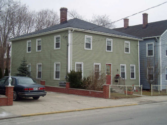
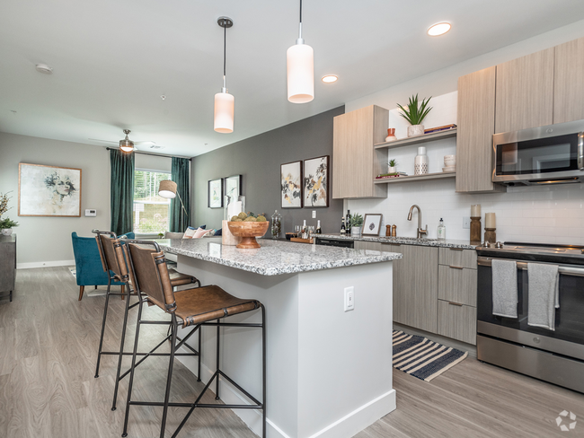
Discover a new place to live at 511 High St in Central Falls, RI. This community is located at 511 High St. in the 02863 area of Central Falls. Here at this community, the leasing team is ready to help you find your new place. Be sure to see the current floorplan options. Stop by 511 High St today.
511 High St is an apartment community located in Providence County and the 02863 ZIP Code. This area is served by the Central Falls attendance zone.
Fees and Policies
Details
Property Information
-
Built in 1900
-
5 units/2 stories
 This Property
 Available Property
As the tiniest town in the smallest state, Central Falls is only about one square mile. But that square mile is one of the most densely populated, home to about 20,000 residents. In 1676, Central Falls was the site of a major battle during King Philip's War -- a conflict between Native Americans and English colonists. Today, the nine colonists killed during the ambush are remembered with Jenks Park, a historic park built in 1890 and including Cogswell Tower, built on the historic Dexter's Lodge.
Today, Central Falls celebrates its history with a variety of sites, including several mills such as the Valley Falls Mill Complex and the Conant Thread Company Mills. Central Falls also features two historic districts: Central Falls Mill Historic District and South Central Falls Historic District. Residents and visitors of Central Falls enjoy the River Island Campground, a four-acre park along the Blackstone River that offers canoeing, kayaking, fishing, and hiking.
Learn more about living in Central Falls| Colleges & Universities | Distance | ||
|---|---|---|---|
| Colleges & Universities | Distance | ||
| Drive: | 10 min | 4.5 mi | |
| Drive: | 10 min | 5.2 mi | |
| Drive: | 12 min | 5.5 mi | |
| Drive: | 9 min | 5.8 mi |
Transportation options available in Central Falls include Mattapan Station, located 33.5 miles from 511 High St. 511 High St is near Rhode Island Tf Green International, located 13.9 miles or 25 minutes away.
| Transit / Subway | Distance | ||
|---|---|---|---|
| Transit / Subway | Distance | ||
|
|
Drive: | 44 min | 33.5 mi |
|
|
Drive: | 45 min | 33.9 mi |
|
|
Drive: | 45 min | 34.0 mi |
|
|
Drive: | 45 min | 34.8 mi |
|
|
Drive: | 47 min | 35.7 mi |
| Commuter Rail | Distance | ||
|---|---|---|---|
| Commuter Rail | Distance | ||
| Walk: | 18 min | 1.0 mi | |
|
|
Drive: | 4 min | 2.3 mi |
|
|
Drive: | 9 min | 5.7 mi |
|
|
Drive: | 11 min | 7.1 mi |
| Drive: | 21 min | 13.2 mi |
| Airports | Distance | ||
|---|---|---|---|
| Airports | Distance | ||
|
Rhode Island Tf Green International
|
Drive: | 25 min | 13.9 mi |
Time and distance from 511 High St.
| Shopping Centers | Distance | ||
|---|---|---|---|
| Shopping Centers | Distance | ||
| Drive: | 2 min | 1.2 mi | |
| Drive: | 3 min | 1.2 mi | |
| Drive: | 2 min | 1.4 mi |
| Parks and Recreation | Distance | ||
|---|---|---|---|
| Parks and Recreation | Distance | ||
|
Blackstone Valley Outfitters
|
Drive: | 5 min | 2.9 mi |
|
Ladd Observatory
|
Drive: | 8 min | 3.6 mi |
|
Lincoln Woods State Park
|
Drive: | 7 min | 3.7 mi |
|
Caratunk Wildlife Refuge
|
Drive: | 9 min | 4.5 mi |
|
Roger Williams National Memorial
|
Drive: | 10 min | 5.4 mi |
| Hospitals | Distance | ||
|---|---|---|---|
| Hospitals | Distance | ||
| Drive: | 5 min | 3.0 mi | |
| Drive: | 9 min | 5.5 mi | |
| Drive: | 10 min | 5.5 mi |
| Military Bases | Distance | ||
|---|---|---|---|
| Military Bases | Distance | ||
| Drive: | 40 min | 26.2 mi | |
| Drive: | 55 min | 36.8 mi |
You May Also Like
Similar Rentals Nearby
What Are Walk Score®, Transit Score®, and Bike Score® Ratings?
Walk Score® measures the walkability of any address. Transit Score® measures access to public transit. Bike Score® measures the bikeability of any address.
What is a Sound Score Rating?
A Sound Score Rating aggregates noise caused by vehicle traffic, airplane traffic and local sources





Responded To This Review