
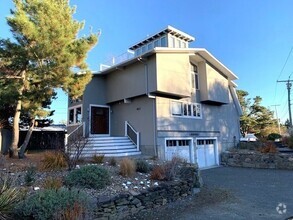
52 Salt Island Rd
52 Salt Island Rd
Gloucester, MA 01930
2 Weeks Ago
Favorites
52 Salt Island Rd

Favorites
Check Back Soon for Upcoming Availability
| Beds | Baths | Average SF |
|---|---|---|
| 4 Bedrooms 4 Bedrooms 4 Br | 3 Baths 3 Baths 3 Ba | 3,500 SF |
About This Property
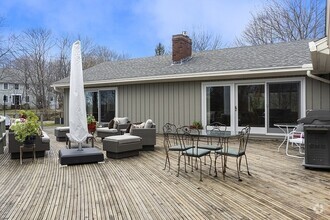
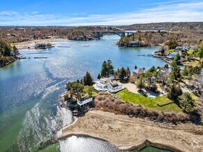
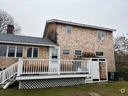
Private Good Harbor Beach-Unobstructed views from nearly every room from this gorgeous custom built newly renovated home. This fully furnished gem has been thoughtfully decorated and appointed. All high end finishes with stunning kitchen with granite counters and center island compliment this homes open floor plan. First floor bedroom can be used as master. Must have great credit and references. NO PETS AND NO SMOKING. There is use of one garage bay and no use of the basement area.
52 Salt Island Rd is a house located in Essex County and the 01930 ZIP Code. This area is served by the Gloucester attendance zone.
House Features
Air Conditioning
Dishwasher
Microwave
Range
- Air Conditioning
- Dishwasher
- Microwave
- Range
- Tennis Court
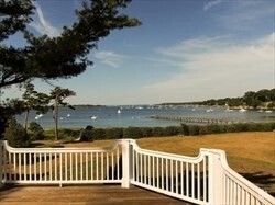
- Deck
Fees and Policies
Location
Get Directions
Close to New Hampshire, 40 minutes north of Boston and nestled along the shores of the Atlantic, the Outer North Shore neighborhood awaits you in the town of Essex. Providing rural living with plenty of water-related activities and located amongst other historically popular North Shore communities, the Outer North Shore neighborhood remains a desirable destination for retirees, married couples and even some families.
All that yearn to be near the ocean and close to Boston can have the best of both worlds residing in Outer North Shore. With a lower cost of living, waterfront properties and modern day conveniences, the neighborhood appeals to ex-Bostonians, who often head here to live in a quieter community.
Learn more about living in North ShoreBelow are rent ranges for similar nearby apartments
Amenities
- Air Conditioning
- Dishwasher
- Microwave
- Range
- Deck
- Tennis Court
Education
| Colleges & Universities | Distance | ||
|---|---|---|---|
| Colleges & Universities | Distance | ||
| Drive: | 19 min | 12.2 mi | |
| Drive: | 26 min | 14.7 mi | |
| Drive: | 34 min | 20.4 mi | |
| Drive: | 33 min | 21.2 mi |
52 Salt Island Rd is within 19 minutes or 12.2 miles from Gordon College, Wenham. It is also near Endicott College and Salem State University.
Schools


Public Elementary School
Grades PK-5
304 Students
Nearby
Public Elementary School
Grades K-5
181 Students
Attendance Zone
Public Middle School
Grades 6-8
622 Students
Attendance Zone
Public High School
Grades 9-12
804 Students
Attendance Zone
Private Elementary, Middle & High School
Grades PK-12
345 Students
Nearby
Private Elementary & Middle School
Grades PK-8
129 Students
Nearby
School data provided by
 The GreatSchools Rating helps parents compare schools within a state based on a variety of school quality indicators and provides a helpful picture of how effectively each school serves all of its students. Ratings are on a scale of 1 (below average) to 10 (above average) and can include test scores, college readiness, academic progress, advanced courses, equity, discipline and attendance data. We also advise parents to visit schools, consider other information on school performance and programs, and consider family needs as part of the school selection process.
View GreatSchools Rating Methodology
View GreatSchools Rating Methodology
Transportation options available in Gloucester include Wonderland Station, located 28.9 miles from 52 Salt Island Rd. 52 Salt Island Rd is near General Edward Lawrence Logan International, located 33.3 miles or 56 minutes away, and Portsmouth International at Pease, located 48.8 miles or 76 minutes away.
| Transit / Subway | Distance | ||
|---|---|---|---|
| Transit / Subway | Distance | ||
|
|
Drive: | 48 min | 28.9 mi |
|
|
Drive: | 48 min | 29.2 mi |
|
|
Drive: | 49 min | 30.0 mi |
|
|
Drive: | 50 min | 30.5 mi |
|
|
Drive: | 51 min | 31.1 mi |
| Commuter Rail | Distance | ||
|---|---|---|---|
| Commuter Rail | Distance | ||
|
|
Drive: | 7 min | 3.4 mi |
|
|
Drive: | 8 min | 4.0 mi |
|
|
Drive: | 10 min | 5.2 mi |
|
|
Drive: | 18 min | 10.5 mi |
|
|
Drive: | 21 min | 12.7 mi |
| Airports | Distance | ||
|---|---|---|---|
| Airports | Distance | ||
|
General Edward Lawrence Logan International
|
Drive: | 56 min | 33.3 mi |
|
Portsmouth International at Pease
|
Drive: | 76 min | 48.8 mi |
Time and distance from 52 Salt Island Rd.
| Shopping Centers | Distance | ||
|---|---|---|---|
| Shopping Centers | Distance | ||
| Drive: | 3 min | 1.2 mi | |
| Drive: | 4 min | 1.5 mi | |
| Drive: | 4 min | 1.8 mi |
52 Salt Island Rd has 3 shopping centers within 1.8 miles, which is about a 4-minute drive. The miles and minutes will be for the farthest away property.
| Parks and Recreation | Distance | ||
|---|---|---|---|
| Parks and Recreation | Distance | ||
|
Mass Audubon's Eastern Point Wildlife Sanctuary
|
Drive: | 10 min | 4.2 mi |
|
Halibut Point State Park
|
Drive: | 13 min | 6.5 mi |
|
Coolidge Reservation
|
Drive: | 13 min | 7.2 mi |
|
Sandy Point State Reservation
|
Drive: | 75 min | 35.1 mi |
52 Salt Island Rd has 4 parks within 35.1 miles, including Mass Audubon's Eastern Point Wildlife Sanctuary, Halibut Point State Park, and Coolidge Reservation.
| Military Bases | Distance | ||
|---|---|---|---|
| Military Bases | Distance | ||
| Drive: | 33 min | 19.6 mi | |
| Drive: | 41 min | 23.8 mi |
52 Salt Island Rd is 19.6 miles from Fort Pickering, and is convenient to other military bases, including Fort Miller.
You May Also Like
Similar Rentals Nearby


What Are Walk Score®, Transit Score®, and Bike Score® Ratings?
Walk Score® measures the walkability of any address. Transit Score® measures access to public transit. Bike Score® measures the bikeability of any address.
What is a Sound Score Rating?
A Sound Score Rating aggregates noise caused by vehicle traffic, airplane traffic and local sources
52 Salt Island Rd
Gloucester, MA 01930