$2,600 / Month
52A King St Unit A
Boston, MA 02122
Today
Favorites
617-943-5818
-
Bedrooms
1
-
Bathrooms
1
-
Square Feet
1,100 sq ft
-
Available
Available Now
Highlights
- Deck
- Property is near public transit
- No Cooling
- Park
- 1 Car Garage
- Laundry Facilities
52A King St Unit A

Favorites
About This Home
Available Now
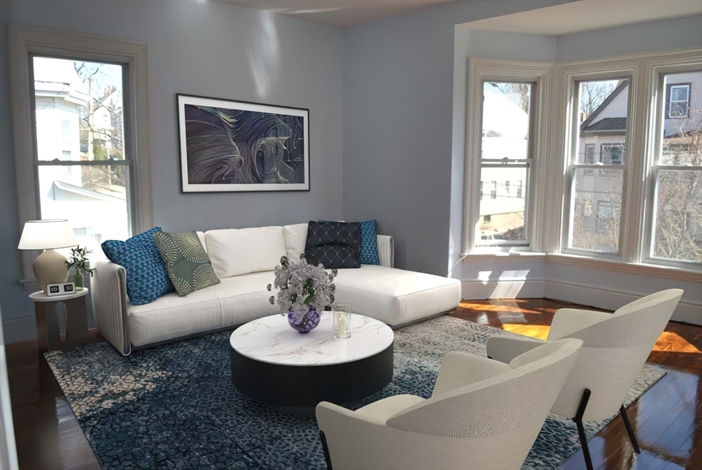
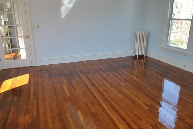
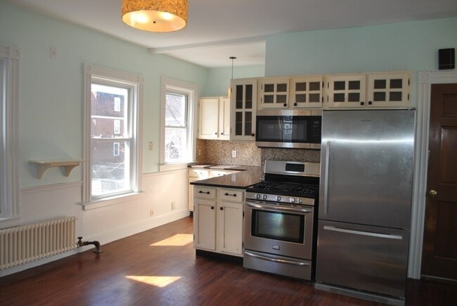
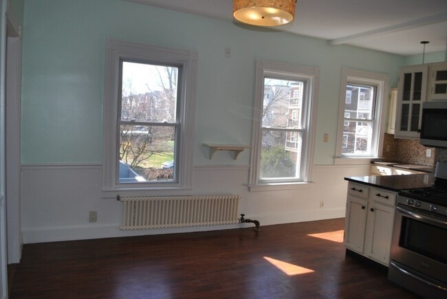
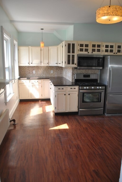
Available June 1st! OVERSIZE 1BR apartment with 2c parking!! Convenient location with in a 15 minute walk to Redline T. SUNNY Second floor unit offers HW floors,original detailing,HUGE rooms and updated kitchen and bath. Extra large BR with lots of room to spare. Eat in kitchen with granite counters and stainless steel appliances: gas stove,microwave,DW,refrigerator and disposal. PRIVATE deck,shared rear yard,laundry on site,basement storage & 2 car PARKING- 1 garage,1 driveway. Tenants pay gas and electric,NO PETS,NO SMOKERS. 1 year lease required,1st month,last month and full Realtor fee due at lease signing.
52A King St is an apartment community located in Suffolk County and the 02122 ZIP Code.
* Price shown is base rent and may not include non-optional fees and utilities.
Price, availability, fees, and any applicable rent special are subject to change without notice.
* Square footage definitions vary. Displayed square footage is approximate.
Home Details
Accessible Home Design
Entry on the 2nd floor
Bedrooms and Bathrooms
1 Full Bathroom
1 Bedroom
Home Design
Apartment
Interior Spaces
1,100 Sq Ft Home
Kitchen
Range
Microwave
Dishwasher
Disposal
Listing and Financial Details
Property Available on 6/1/25
12 Month Lease Term
Assessor Parcel Number 1303479
Rent includes occupancy only
Location
Property is near public transit
Outdoor Features
Deck
Parking
1 Car Garage
Utilities
No Cooling
Community Details
Amenities
Laundry Facilities
Overview
No Home Owners Association
Pet Policy
No Pets Allowed
Recreation
Park
Fees and Policies
The fees below are based on community-supplied data and may exclude additional fees and utilities.
Contact
- Listed by Lynn Hollenbeck | Seaport Realty Group
- Phone Number
-
Source
 MLS Property Information Network
The property listing data and information set forth herein were provided to MLS Property Information Network, Inc. from third party sources, including sellers, lessors and public records, and were compiled by MLS Property Information Network, Inc. The property listing data and information are for the personal, non-commercial use of consumers having a good faith interest in purchasing or leasing listed properties of the type displayed to them and may not be used for any purpose other than to identify prospective properties which such consumers may have a good faith interest in purchasing or leasing. MLS Property Information Network, Inc. and its subscribers disclaim any and all representations and warranties as to the accuracy of the property listing data and information set forth herein. All properties are subject to prior sale, change or withdrawal. Copyright © 2025 MLS Property Information Network, Inc. All rights reserved.
Location
Get Directions
Amenities
- Dishwasher
- Disposal
- Microwave
- Range
- Refrigerator
- Deck
A quick six miles directly south of Downtown Boston lies the close-knit community of Saintt. Marks, tightly packed with multi-family, triple-decker houses for rent. Workers reach the center of the city in less than 30 minutes by driving up Interstate 93 or taking the MBTA red line from Shawmut station. Dorchester Avenue runs through the heart of St. Marks, giving residents an active commercial district with homes lining the side streets.
Franklin Park, just two miles west of St. Marks, provides a large green space filled with wetlands, fields, and ponds. This is the location of the Franklin Park Zoo, the Franklin Park Playstead, and the William J. Devine Golf Course. Head a couple of blocks east to the parks along the Neponset River, including the dog-friendly Victory Road Park or to Tenean Beach, which offers a boardwalk, picnic areas, and a playground. During the summer and fall, head to the nearby Ashmont/Peabody Square Farmers Market to pick up some local New England produce.
Learn more about living in St Marks
Education
| Colleges & Universities | Distance | ||
|---|---|---|---|
| Colleges & Universities | Distance | ||
| Drive: | 7 min | 2.6 mi | |
| Drive: | 10 min | 4.4 mi | |
| Drive: | 11 min | 4.7 mi | |
| Drive: | 11 min | 4.8 mi |
52A King St Unit A is within 7 minutes or 2.6 miles from UMass Boston. It is also near Northeastern University and Wentworth Inst. of Technology.
Transportation options available in Boston include Shawmut Station, located 0.6 mile from 52A King St Unit A. 52A King St Unit A is near General Edward Lawrence Logan International, located 8.0 miles or 16 minutes away.
| Transit / Subway | Distance | ||
|---|---|---|---|
| Transit / Subway | Distance | ||
|
|
Walk: | 11 min | 0.6 mi |
|
|
Walk: | 14 min | 0.7 mi |
|
|
Walk: | 16 min | 0.8 mi |
|
|
Drive: | 3 min | 1.2 mi |
|
|
Drive: | 7 min | 3.4 mi |
| Commuter Rail | Distance | ||
|---|---|---|---|
| Commuter Rail | Distance | ||
| Drive: | 3 min | 1.3 mi | |
| Drive: | 5 min | 1.7 mi | |
|
|
Drive: | 4 min | 2.2 mi |
|
|
Drive: | 5 min | 2.3 mi |
|
|
Drive: | 7 min | 2.6 mi |
| Airports | Distance | ||
|---|---|---|---|
| Airports | Distance | ||
|
General Edward Lawrence Logan International
|
Drive: | 16 min | 8.0 mi |
Time and distance from 52A King St Unit A.
| Shopping Centers | Distance | ||
|---|---|---|---|
| Shopping Centers | Distance | ||
| Walk: | 12 min | 0.6 mi | |
| Walk: | 14 min | 0.8 mi | |
| Walk: | 15 min | 0.8 mi |
52A King St Unit A has 3 shopping centers within 0.8 mile, which is about a 15-minute walk. The miles and minutes will be for the farthest away property.
| Parks and Recreation | Distance | ||
|---|---|---|---|
| Parks and Recreation | Distance | ||
|
Dorchester Shores Reservation
|
Drive: | 6 min | 2.5 mi |
|
Lower Neponset River Trail
|
Drive: | 6 min | 2.6 mi |
|
Franklin Park Zoo
|
Drive: | 6 min | 2.6 mi |
|
Squantum Point Park
|
Drive: | 8 min | 3.1 mi |
|
Mass Audubon's Boston Nature Center and Wildlife Sanctuary
|
Drive: | 7 min | 3.5 mi |
52A King St Unit A has 5 parks within 3.5 miles, including Lower Neponset River Trail, Franklin Park Zoo, and Dorchester Shores Reservation.
| Hospitals | Distance | ||
|---|---|---|---|
| Hospitals | Distance | ||
| Drive: | 3 min | 1.3 mi | |
| Drive: | 7 min | 3.5 mi | |
| Drive: | 8 min | 3.6 mi |
52A King St Unit A has 3 hospitals within 3.6 miles, the nearest is Carney Hospital which is 1.3 miles away and a 3 minute drive.
You May Also Like
Similar Rentals Nearby


What Are Walk Score®, Transit Score®, and Bike Score® Ratings?
Walk Score® measures the walkability of any address. Transit Score® measures access to public transit. Bike Score® measures the bikeability of any address.
What is a Sound Score Rating?
A Sound Score Rating aggregates noise caused by vehicle traffic, airplane traffic and local sources

52A King St
Boston, MA 02122