
$4,200 / Month
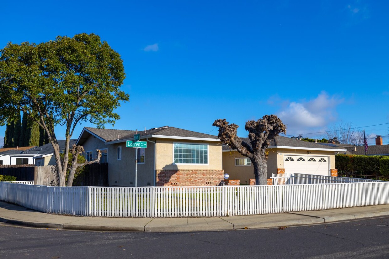
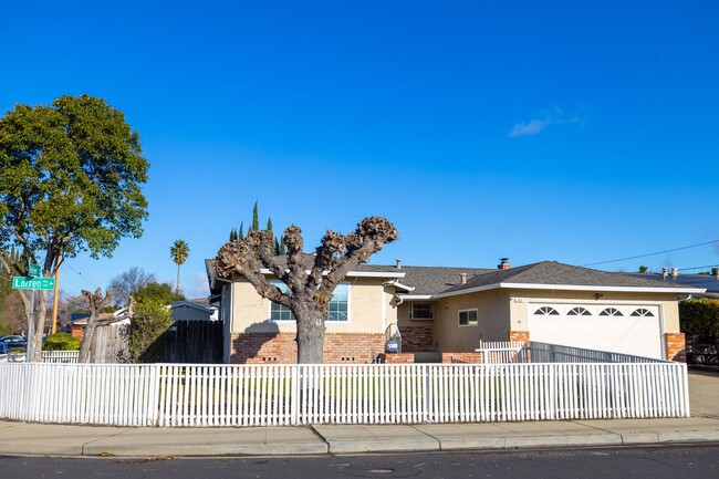
554 Lorren Way
Livermore, CA 94550
Today
Favorites
510-621-6637
-
Bedrooms
4
-
Bathrooms
3
-
Square Feet
1,779 sq ft
-
Available
Available Now
554 Lorren Way

Favorites
About This Home
$4,200 deposit,
Available Now
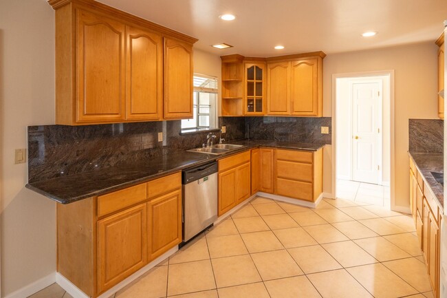
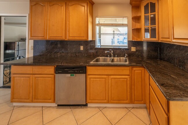
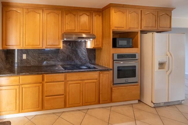
Lovely expanded 4 bedroom and 3 full bath home for rent in Livermore, with two master suites! Lots of remodeling: All new interior paint, Granite kitchen counters, newer engineered hardwood floors, newer bathroom vanities, dual pane windows, newer roof. There is a pellet stove in the living room to provide extra warmth and ambiance in the Winter and AC to keep you cool in the Summer. Washer and dryer included. Contact us to see the virtual tour.
554 Lorren Way is a house located in Alameda County and the 94550 ZIP Code. This area is served by the Livermore Valley Joint Unified attendance zone.
* Price shown is base rent and may not include non-optional fees and utilities.
Price, availability, fees, and any applicable rent special are subject to change without notice.
* Square footage definitions vary. Displayed square footage is approximate.
House Features
- Dishwasher
Contact
- Listed by Perkins Realty Partners | Perkins Realty Partners
- Phone Number
- Contact
$4,420 / month
$749,900 Listing Price
4 Beds
•3 Baths
•
2,158 Sq Ft
$4,379 / month
$699,500 Listing Price
4 Beds
•3 Baths
•
1,863 Sq Ft
$4,679 / month
$723,999 Listing Price
4 Beds
•3 Baths
•
2,287 Sq Ft
Location
Get Directions
Amenities
- Dishwasher
The cities of Livermore, Dublin and Pleasanton form a loosely shaped triangle within California's Tri-Valley region, a cluster of three small valleys about 33 miles east of San Francisco and 35 miles northeast of San Jose. Known for its Mediterranean climate, rolling hills and historic vineyards, this once bucolic region now boasts three separate downtown areas, a bustling business community and some of the best wineries in the state.
At the eastern end of the region lies the city of Livermore. Once known as Livermores, Livermore Ranch and Nottingham, the city sits at the center of Livermore Valley, a historic region dotted with more than 5,000 acres of mostly family-owned vineyards. A pastoral neighborhood known for its charming yet functional hilltop windmills, Livermore hosts the internationally recognized and sometimes controversial center of scientific research, Lawrence Livermore National Laboratories.
Learn more about living in Dublin/Pleasanton/Livermore
Education
| Colleges & Universities | Distance | ||
|---|---|---|---|
| Colleges & Universities | Distance | ||
| Drive: | 10 min | 4.3 mi | |
| Drive: | 21 min | 13.0 mi | |
| Drive: | 24 min | 15.3 mi | |
| Drive: | 24 min | 16.6 mi |
554 Lorren Way is within 10 minutes or 4.3 miles from Las Positas College. It is also near Diablo Valley Coll, San Ramon and Ohlone College, Fremont Campus.
Schools


Public Elementary School
Grades K-5
478 Students
Nearby
Public Elementary & Middle School
Grades K-8
786 Students
Attendance Zone
Public High School
Grades 9-12
2,279 Students
Attendance Zone
Private Elementary School
Grades PK-3
64 Students
Nearby
Private Elementary & Middle School
Grades K-8
233 Students
Nearby
Private High School
Grades 9-12
Nearby
School data provided by
 The GreatSchools Rating helps parents compare schools within a state based on a variety of school quality indicators and provides a helpful picture of how effectively each school serves all of its students. Ratings are on a scale of 1 (below average) to 10 (above average) and can include test scores, college readiness, academic progress, advanced courses, equity, discipline and attendance data. We also advise parents to visit schools, consider other information on school performance and programs, and consider family needs as part of the school selection process.
View GreatSchools Rating Methodology
View GreatSchools Rating Methodology
Transportation options available in Livermore include Dublin Pleasanton Station, located 9.8 miles from 554 Lorren Way. 554 Lorren Way is near Metro Oakland International, located 28.6 miles or 37 minutes away, and Norman Y Mineta San Jose International, located 30.2 miles or 41 minutes away.
| Transit / Subway | Distance | ||
|---|---|---|---|
| Transit / Subway | Distance | ||
|
|
Drive: | 14 min | 9.8 mi |
|
|
Drive: | 14 min | 10.1 mi |
|
|
Drive: | 25 min | 17.7 mi |
|
|
Drive: | 28 min | 17.7 mi |
|
|
Drive: | 34 min | 20.2 mi |
| Commuter Rail | Distance | ||
|---|---|---|---|
| Commuter Rail | Distance | ||
| Drive: | 5 min | 2.1 mi | |
| Drive: | 10 min | 5.4 mi | |
| Drive: | 12 min | 5.9 mi | |
| Drive: | 31 min | 19.4 mi | |
|
|
Drive: | 30 min | 21.0 mi |
| Airports | Distance | ||
|---|---|---|---|
| Airports | Distance | ||
|
Metro Oakland International
|
Drive: | 37 min | 28.6 mi |
|
Norman Y Mineta San Jose International
|
Drive: | 41 min | 30.2 mi |
Time and distance from 554 Lorren Way.
| Shopping Centers | Distance | ||
|---|---|---|---|
| Shopping Centers | Distance | ||
| Walk: | 16 min | 0.9 mi | |
| Drive: | 3 min | 1.1 mi | |
| Drive: | 4 min | 1.5 mi |
554 Lorren Way has 3 shopping centers within 1.5 miles, which is about a 4-minute walk. The miles and minutes will be for the farthest away property.
| Parks and Recreation | Distance | ||
|---|---|---|---|
| Parks and Recreation | Distance | ||
|
Shadow Cliffs Regional Recreation Area
|
Drive: | 8 min | 3.5 mi |
|
Brushy Peak Regional Preserve
|
Drive: | 18 min | 9.4 mi |
|
Del Valle Regional Park
|
Drive: | 28 min | 10.2 mi |
|
Los Vaqueros Watershed
|
Drive: | 19 min | 10.9 mi |
554 Lorren Way has 4 parks within 10.9 miles, including Shadow Cliffs Regional Recreation Area, Brushy Peak Regional Preserve, and Del Valle Regional Park.
| Hospitals | Distance | ||
|---|---|---|---|
| Hospitals | Distance | ||
| Drive: | 11 min | 6.0 mi |
554 Lorren Way is 6.0 miles and a 11 minute drive from Stanford Health Care - ValleyCare.
You May Also Like
Similar Rentals Nearby


What Are Walk Score®, Transit Score®, and Bike Score® Ratings?
Walk Score® measures the walkability of any address. Transit Score® measures access to public transit. Bike Score® measures the bikeability of any address.
What is a Sound Score Rating?
A Sound Score Rating aggregates noise caused by vehicle traffic, airplane traffic and local sources

554 Lorren Way
Livermore, CA 94550