-
558 Main Street
558 Main St
558 Main St,
Lynnfield,
MA
01940
2 Weeks Ago
Favorites
558 Main St

Favorites
Check Back Soon for Upcoming Availability
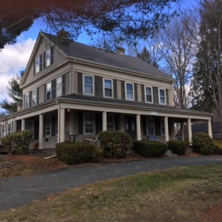
About 558 Main St Lynnfield, MA 01940
This apartment is coming soon and will include interior photographs. This apartment is in the historical General George Whittridge home in the historical section of Lynnfield Center. The two bedroom unit was completely renovated and is on the first floor. There is also a large backyard with a brick patio for summer barbeques. The interior of the unit features hardwood floors throughout and a ceramic tile bathroom. The eat-in kitchen with island has natural cherry Thomasville cabinets with granite countertops and stainless steel appliances. There is also a washer/dryer inside of this unit for your convenience. There is off-street parking, and the owner provides snow removal and landscape services. The house is heated with a brand new high efficiency Carrier gas furnace. For additional information, please call for more information.
558 Main St is an apartment community located in Essex County and the 01940 ZIP Code.
Apartment Features
Washer/Dryer
Hardwood Floors
Granite Countertops
Stainless Steel Appliances
- Washer/Dryer
- Smoke Free
- Granite Countertops
- Stainless Steel Appliances
- Eat-in Kitchen
- Kitchen
- Hardwood Floors
- Furnished
- Patio
- Yard
Fees and Policies
The fees below are based on community-supplied data and may exclude additional fees and utilities.
- Parking
-
Surface Lot--
Details
Lease Options
-
12 Months
Property Information
-
Furnished Units Available
Location
Get Directions
The suburbs north of Boston along the I-95 corridor in Essex County constitute a mix of rolling wooded hills, housing developments, sleepy New England villages and coastal lakes and marshes. Bedroom communities such as Lynnfield, Peabody and Danvers give way to the smaller working communities of Essex and Gloucester. Tourists pass through on their way to Rockport or Willowdale State Forest. Depending on location, homes of every style and size can be found here.
Learn more about living in LynnfieldBelow are rent ranges for similar nearby apartments
Amenities
- Washer/Dryer
- Smoke Free
- Granite Countertops
- Stainless Steel Appliances
- Eat-in Kitchen
- Kitchen
- Hardwood Floors
- Furnished
- Patio
- Yard
Education
| Colleges & Universities | Distance | ||
|---|---|---|---|
| Colleges & Universities | Distance | ||
| Drive: | 16 min | 8.4 mi | |
| Drive: | 17 min | 8.9 mi | |
| Drive: | 22 min | 11.0 mi | |
| Drive: | 24 min | 12.7 mi |
558 Main St is within 16 minutes or 8.4 miles from North Shore C.C., Danvers. It is also near North Shore C.C., Lynn Campus and Salem State University.
Transportation options available in Lynnfield include Oak Grove Station, located 9.8 miles from 558 Main St. 558 Main St is near General Edward Lawrence Logan International, located 15.1 miles or 27 minutes away, and Manchester Boston Regional, located 42.0 miles or 62 minutes away.
| Transit / Subway | Distance | ||
|---|---|---|---|
| Transit / Subway | Distance | ||
|
|
Drive: | 17 min | 9.8 mi |
|
|
Drive: | 20 min | 11.2 mi |
|
|
Drive: | 21 min | 11.5 mi |
|
|
Drive: | 19 min | 12.3 mi |
|
|
Drive: | 21 min | 13.6 mi |
| Commuter Rail | Distance | ||
|---|---|---|---|
| Commuter Rail | Distance | ||
|
|
Drive: | 8 min | 3.4 mi |
|
|
Drive: | 8 min | 3.6 mi |
|
|
Drive: | 11 min | 4.4 mi |
|
|
Drive: | 12 min | 7.1 mi |
|
|
Drive: | 14 min | 7.8 mi |
| Airports | Distance | ||
|---|---|---|---|
| Airports | Distance | ||
|
General Edward Lawrence Logan International
|
Drive: | 27 min | 15.1 mi |
|
Manchester Boston Regional
|
Drive: | 62 min | 42.0 mi |
Time and distance from 558 Main St.
| Shopping Centers | Distance | ||
|---|---|---|---|
| Shopping Centers | Distance | ||
| Walk: | 2 min | 0.1 mi | |
| Drive: | 5 min | 2.4 mi | |
| Drive: | 5 min | 2.8 mi |
558 Main St has 3 shopping centers within 2.8 miles, which is about a 5-minute walk. The miles and minutes will be for the farthest away property.
| Parks and Recreation | Distance | ||
|---|---|---|---|
| Parks and Recreation | Distance | ||
|
Breakheart Reservation
|
Drive: | 15 min | 5.1 mi |
|
Saugus Ironworks National Historic Site
|
Drive: | 12 min | 6.0 mi |
|
Lynn Woods
|
Drive: | 12 min | 6.4 mi |
|
Walter D. Stone Memorial Zoo
|
Drive: | 14 min | 7.5 mi |
|
Harold Parker State Forest
|
Drive: | 18 min | 8.2 mi |
558 Main St has 5 parks within 8.2 miles, including Breakheart Reservation, Saugus Ironworks National Historic Site, and Lynn Woods.
| Hospitals | Distance | ||
|---|---|---|---|
| Hospitals | Distance | ||
| Drive: | 14 min | 7.5 mi | |
| Drive: | 15 min | 7.8 mi | |
| Drive: | 19 min | 9.3 mi |
558 Main St has 3 hospitals within 9.3 miles, the nearest is MelroseWakefield Healthcare which is 7.5 miles away and a 14 minute drive.
| Military Bases | Distance | ||
|---|---|---|---|
| Military Bases | Distance | ||
| Drive: | 23 min | 11.3 mi | |
| Drive: | 29 min | 14.5 mi |
558 Main St is 11.3 miles from Fort Pickering, and is convenient to other military bases, including Fort Miller.
You May Also Like
Similar Rentals Nearby


What Are Walk Score®, Transit Score®, and Bike Score® Ratings?
Walk Score® measures the walkability of any address. Transit Score® measures access to public transit. Bike Score® measures the bikeability of any address.
What is a Sound Score Rating?
A Sound Score Rating aggregates noise caused by vehicle traffic, airplane traffic and local sources