5625 Sandmound Blvd
Oakley, CA 94561
-
Bedrooms
2
-
Bathrooms
1
-
Square Feet
600 sq ft
-
Available
Available Now
Highlight
- Pets Allowed

About This Home
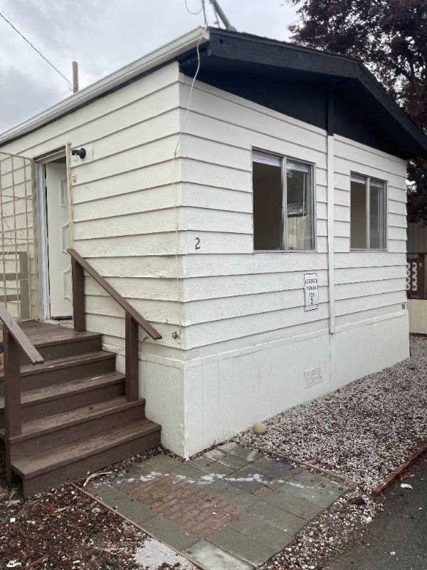
Property Id: 1546009 THIS MANUFACTURED HOME IS LOCATED IN QUIET PARK NEAR BETHEL ISLAND. FRESHLY PAINTED WITH CARPET AND LAMINATE FLOORING WASHER AND PROPANE GAS HOOK UP FOR DRYER OFF STREET PARKING IN FRONT OF UNIT RENT IS $1500 WITH THOUSAND DOLLAR DEPOSIT TENANT PAYS SEWER, GARBAGE, GAS AND ELECTRICITY
5625 Sandmound Blvd is a townhome located in Contra Costa County and the 94561 ZIP Code. This area is served by the Oakley Union Elementary attendance zone.
Townhome Features
- Disposal
- Oven
- Refrigerator
Fees and Policies
The fees below are based on community-supplied data and may exclude additional fees and utilities.
- Dogs Allowed
-
Fees not specified
- Cats Allowed
-
Fees not specified
Details
Utilities Included
-
Water
Contact
- Phone Number
- Contact
-
Source

- Disposal
- Oven
- Refrigerator
| Colleges & Universities | Distance | ||
|---|---|---|---|
| Colleges & Universities | Distance | ||
| Drive: | 19 min | 8.0 mi | |
| Drive: | 34 min | 16.3 mi | |
| Drive: | 64 min | 38.0 mi | |
| Drive: | 66 min | 39.3 mi |


View GreatSchools Rating Methodology
Transportation options available in Oakley include Antioch, located 10.9 miles from 5625 Sandmound Blvd. 5625 Sandmound Blvd is near Stockton Metro, located 39.9 miles or 65 minutes away.
| Transit / Subway | Distance | ||
|---|---|---|---|
| Transit / Subway | Distance | ||
|
|
Drive: | 22 min | 10.9 mi |
|
|
Drive: | 29 min | 17.0 mi |
|
|
Drive: | 37 min | 22.8 mi |
|
|
Drive: | 41 min | 25.5 mi |
|
|
Drive: | 44 min | 28.0 mi |
| Commuter Rail | Distance | ||
|---|---|---|---|
| Commuter Rail | Distance | ||
|
|
Drive: | 27 min | 12.7 mi |
| Drive: | 52 min | 30.1 mi | |
|
|
Drive: | 59 min | 35.5 mi |
| Drive: | 61 min | 36.8 mi | |
|
|
Drive: | 72 min | 44.6 mi |
| Airports | Distance | ||
|---|---|---|---|
| Airports | Distance | ||
|
Stockton Metro
|
Drive: | 65 min | 39.9 mi |
Time and distance from 5625 Sandmound Blvd.
| Shopping Centers | Distance | ||
|---|---|---|---|
| Shopping Centers | Distance | ||
| Drive: | 5 min | 1.4 mi | |
| Drive: | 7 min | 2.3 mi | |
| Drive: | 12 min | 4.4 mi |
| Parks and Recreation | Distance | ||
|---|---|---|---|
| Parks and Recreation | Distance | ||
|
Franks Tract State Recreation Area
|
Drive: | 10 min | 3.7 mi |
|
Marsh Creek Regional Trail
|
Drive: | 18 min | 8.0 mi |
|
Big Break Regional Shoreline
|
Drive: | 20 min | 8.0 mi |
|
Brannan Island State Recreation Area
|
Drive: | 34 min | 17.9 mi |
|
Delta Meadows State Park
|
Drive: | 34 min | 17.9 mi |
| Hospitals | Distance | ||
|---|---|---|---|
| Hospitals | Distance | ||
| Drive: | 29 min | 12.7 mi | |
| Drive: | 27 min | 13.5 mi |
| Military Bases | Distance | ||
|---|---|---|---|
| Military Bases | Distance | ||
| Drive: | 58 min | 33.0 mi |
You May Also Like
What Are Walk Score®, Transit Score®, and Bike Score® Ratings?
Walk Score® measures the walkability of any address. Transit Score® measures access to public transit. Bike Score® measures the bikeability of any address.
What is a Sound Score Rating?
A Sound Score Rating aggregates noise caused by vehicle traffic, airplane traffic and local sources

5625 Sandmound Blvd
Oakley, CA 94561