
$2,000 / Month
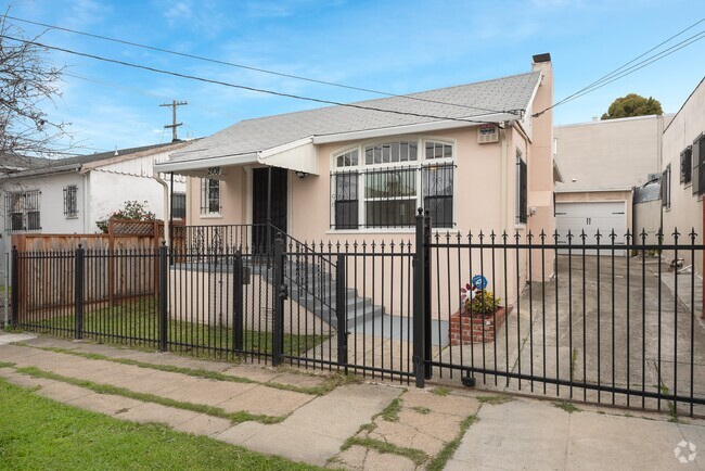
585 E H St
Benicia, CA 94510
Today
Favorites
707-745-0924
-
Bedrooms
1
-
Bathrooms
1
-
Square Feet
--
-
Available
Available Now
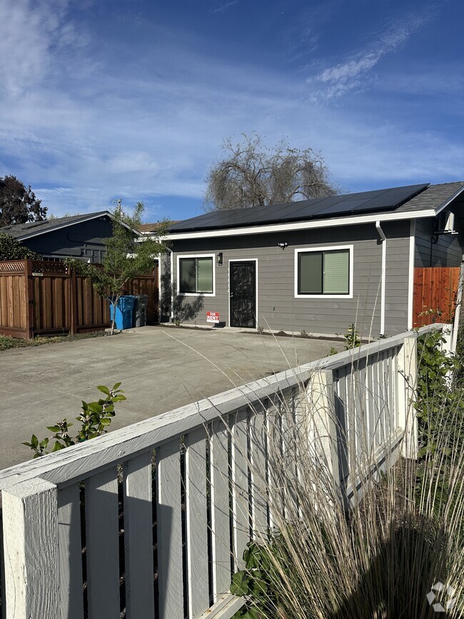
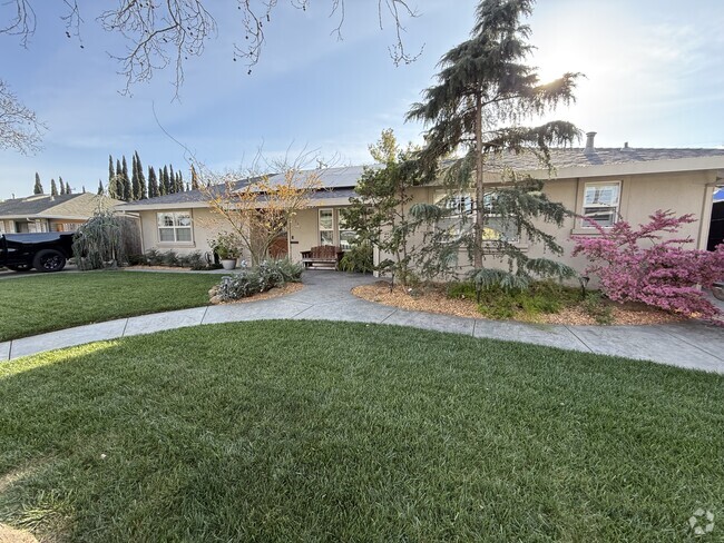
585 E H St

Favorites
About This Home
$2,000 deposit,
Available Now
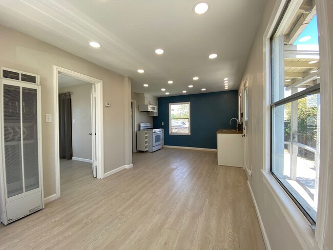
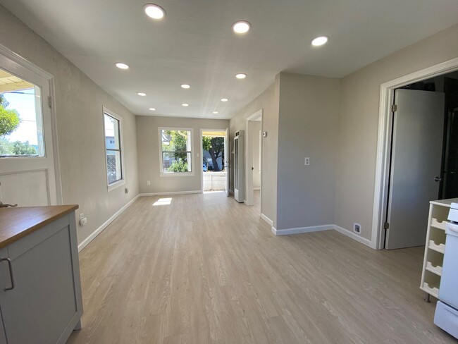
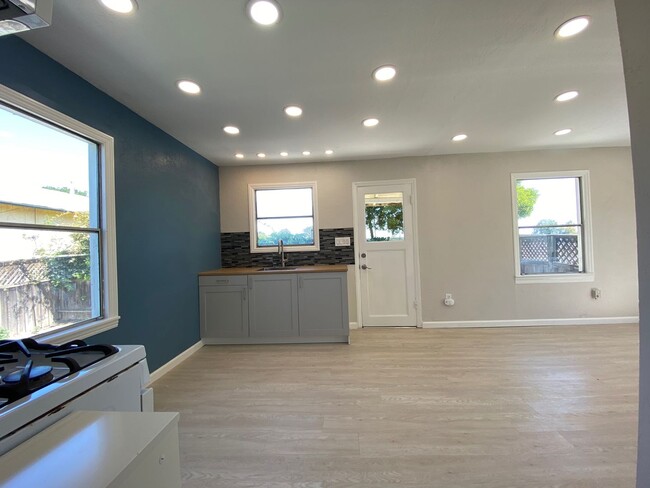
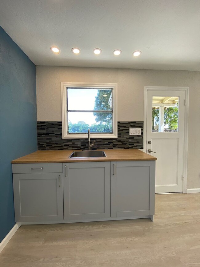
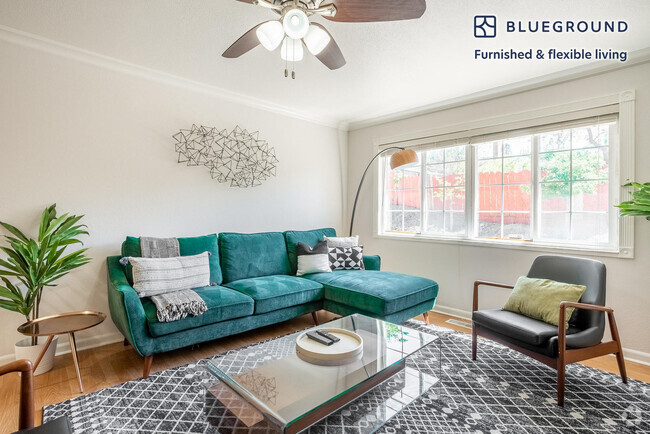
Estey Real Estate presents this lovely Remodeled 1 bedroom and 1 bathroom Cottage with new interior paint. Recess LED lighting and laminate flooring throughout property. Butcher block kitchen countertops, gas stove, microwave and sink. Must bring your own refrigerator. Bathroom with tiled shower. Laundry room off the back of the house with 110 volt and gas hook-ups. Off street parking for 1 car. Fenced yard with concrete patio of kitchen. Renters insurance required. Due to third party listings please refer to our website at Commute distance from San Francisco, Marin County, Sacramento, Walnut Creek area. Requirements: Must make 3 times the monthly rent. Insurance required. No Smoking property. Pets/no pets please got to Lease start date 2 weeks or sooner from application approval. Contact us to schedule a showing. All Estey Real Estate residents are automatically enrolled in the Resident Benefits Package (RBP) for $51.95 which includes renters insurance, HVAC air filter delivery (for applicable properties), credit building to help boost your credit score with timely rent payments, $1M Identity Protection, Pest Control, move-in concierge service making utility connection and home service setup a breeze during your move-in, our best- in-class resident rewards program, and much more! More details upon application.
585 E H St is a house located in Solano County and the 94510 ZIP Code. This area is served by the Benicia Unified attendance zone.
* Price shown is base rent and may not include non-optional fees and utilities.
Price, availability, fees, and any applicable rent special are subject to change without notice.
* Square footage definitions vary. Displayed square footage is approximate.
Contact
- Listed by Estey | Estey Real Estate and Property Management
- Phone Number
- Contact
$2,234 / month
$365,000 Listing Price
3 Beds
•1 Baths
•
1,150 Sq Ft
$2,122 / month
$339,000 Listing Price
2 Beds
•1 Baths
•
900 Sq Ft
$1,808 / month
$275,000 Listing Price
2 Beds
•1 Baths
•
500 Sq Ft
Location
Get Directions
Situated along the Carquinez Strait in the San Francisco Bay Area, Benicia is a scenic waterfront city rich in history, cultural amenities, and sweeping vistas. Benicia boasts an irresistible historic charm, especially in its quaint downtown area, which is brimming with one-of-a-kind shops, delectable eateries, and vibrant artists’ studios.
Founded in 1847, Benicia once served as California’s state capital for 13 months, and now touts the only state capitol building outside of Sacramento. Residents and visitors alike can uncover much of Benicia’s past at the Benicia Historical Museum.
Nearly 500 acres of parkland provides ample green space and tranquil trails for all kinds of outdoor recreation. Benicia’s thriving arts community creates a broad range of art, from glass art and sculptures to theatrical plays and music. Benicia’s friendly community comes together for a variety of events, like the Downtown Farmers Market, Opening Day on the Strait, and artist studio open houses.
Learn more about living in Benicia
Education
| Colleges & Universities | Distance | ||
|---|---|---|---|
| Colleges & Universities | Distance | ||
| Drive: | 15 min | 9.3 mi | |
| Drive: | 21 min | 11.9 mi | |
| Drive: | 23 min | 16.0 mi | |
| Drive: | 25 min | 18.2 mi |
585 E H St is within 15 minutes or 9.3 miles from Diablo Valley, Pleasant Hill. It is also near Touro University California and Solano Community College.
Schools


Public Elementary School
Grades K-5
440 Students
Nearby
Public Elementary School
Grades K-5
444 Students
Attendance Zone
Public Middle School
Grades 6-8
986 Students
Attendance Zone
Public High School
Grades 9-12
1,432 Students
Attendance Zone
Private Elementary & Middle School
Grades PK-8
389 Students
Nearby
Private Elementary & Middle School
Grades PK-8
330 Students
Nearby
Private Middle & High School
Grades 7-12
Nearby
School data provided by
 The GreatSchools Rating helps parents compare schools within a state based on a variety of school quality indicators and provides a helpful picture of how effectively each school serves all of its students. Ratings are on a scale of 1 (below average) to 10 (above average) and can include test scores, college readiness, academic progress, advanced courses, equity, discipline and attendance data. We also advise parents to visit schools, consider other information on school performance and programs, and consider family needs as part of the school selection process.
View GreatSchools Rating Methodology
View GreatSchools Rating Methodology
Transportation options available in Benicia include North Concord Martinez Station, located 10.4 miles from 585 E H St. 585 E H St is near Metro Oakland International, located 36.7 miles or 49 minutes away, and San Francisco International, located 47.9 miles or 65 minutes away.
| Transit / Subway | Distance | ||
|---|---|---|---|
| Transit / Subway | Distance | ||
|
|
Drive: | 16 min | 10.4 mi |
|
|
Drive: | 17 min | 10.9 mi |
|
|
Drive: | 17 min | 12.2 mi |
|
|
Drive: | 18 min | 13.4 mi |
|
|
Drive: | 21 min | 16.7 mi |
| Commuter Rail | Distance | ||
|---|---|---|---|
| Commuter Rail | Distance | ||
|
|
Drive: | 9 min | 5.4 mi |
|
|
Drive: | 26 min | 20.0 mi |
|
|
Drive: | 30 min | 22.0 mi |
|
|
Drive: | 33 min | 25.9 mi |
|
|
Drive: | 36 min | 27.7 mi |
| Airports | Distance | ||
|---|---|---|---|
| Airports | Distance | ||
|
Metro Oakland International
|
Drive: | 49 min | 36.7 mi |
|
San Francisco International
|
Drive: | 65 min | 47.9 mi |
Time and distance from 585 E H St.
| Shopping Centers | Distance | ||
|---|---|---|---|
| Shopping Centers | Distance | ||
| Walk: | 9 min | 0.5 mi | |
| Walk: | 16 min | 0.9 mi | |
| Walk: | 17 min | 0.9 mi |
585 E H St has 3 shopping centers within 0.9 mile, which is about a 17-minute walk. The miles and minutes will be for the farthest away property.
| Parks and Recreation | Distance | ||
|---|---|---|---|
| Parks and Recreation | Distance | ||
|
Benicia Capitol State Historic Park
|
Walk: | 13 min | 0.7 mi |
|
Waterbird Regional Preserve
|
Drive: | 7 min | 4.3 mi |
|
Martinez Regional Shoreline
|
Drive: | 11 min | 4.8 mi |
|
Alhambra Creek Watershed
|
Drive: | 9 min | 5.4 mi |
|
Carquinez Strait Regional Shoreline
|
Drive: | 20 min | 12.2 mi |
585 E H St has 5 parks within 12.2 miles, including Benicia Capitol State Historic Park, Waterbird Regional Preserve, and Martinez Regional Shoreline.
| Hospitals | Distance | ||
|---|---|---|---|
| Hospitals | Distance | ||
| Drive: | 11 min | 6.0 mi | |
| Drive: | 13 min | 8.8 mi | |
| Drive: | 15 min | 9.9 mi |
585 E H St has 3 hospitals within 9.9 miles, the nearest is Contra Costa Regional Medical Center which is 6.0 miles away and a 11 minute drive.
| Military Bases | Distance | ||
|---|---|---|---|
| Military Bases | Distance | ||
| Drive: | 4 min | 1.5 mi | |
| Drive: | 31 min | 13.1 mi |
585 E H St is 1.5 miles from Armory Vallejo, and is convenient to other military bases, including US Naval Station Port Chicago.
You May Also Like
Similar Rentals Nearby
What Are Walk Score®, Transit Score®, and Bike Score® Ratings?
Walk Score® measures the walkability of any address. Transit Score® measures access to public transit. Bike Score® measures the bikeability of any address.
What is a Sound Score Rating?
A Sound Score Rating aggregates noise caused by vehicle traffic, airplane traffic and local sources
585 E H St
Benicia, CA 94510