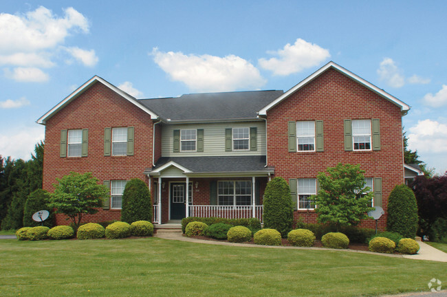
59 Soltis Dr
59 Soltis Dr
Irwin, PA 15642

Check Back Soon for Upcoming Availability
| Beds | Baths | Average SF |
|---|---|---|
| 2 Bedrooms 2 Bedrooms 2 Br | 2 Baths 2 Baths 2 Ba | — |
Nestled in the foothills of the Laurel Mountains, Irwin offers residents a small-town vibe just 20 miles southeast of bustling Pittsburgh. Irwin’s historic Main Street is central to the borough’s small-town feel, with a variety of specialty shops, salons, boutiques, restaurants, offices, and churches in rows of historic buildings within walking distance of one another.
A strong sense of community pride and spirit permeates Irwin, with year-round cultural events and robust recreational programs for all to enjoy. Irwin residents delight in access to the Norwin School District, which is consistently ranked among the best in the state. Convenience to Route 30 and the Pennsylvania Turnpike places Irwin within minutes of Pittsburgh’s abundant amenities, attractions, and employment opportunities.
Learn more about living in Irwin| Colleges & Universities | Distance | ||
|---|---|---|---|
| Colleges & Universities | Distance | ||
| Drive: | 18 min | 10.0 mi | |
| Drive: | 25 min | 12.5 mi | |
| Drive: | 31 min | 15.2 mi | |
| Drive: | 25 min | 15.3 mi |
Transportation options available in Irwin include Mcneilly, located 19.1 miles from 59 Soltis Dr. 59 Soltis Dr is near Arnold Palmer Regional, located 21.4 miles or 39 minutes away, and Pittsburgh International, located 34.6 miles or 55 minutes away.
| Transit / Subway | Distance | ||
|---|---|---|---|
| Transit / Subway | Distance | ||
|
|
Drive: | 34 min | 19.1 mi |
|
|
Drive: | 35 min | 19.3 mi |
|
|
Drive: | 36 min | 19.7 mi |
|
|
Drive: | 37 min | 19.8 mi |
|
|
Drive: | 37 min | 20.1 mi |
| Commuter Rail | Distance | ||
|---|---|---|---|
| Commuter Rail | Distance | ||
|
|
Drive: | 23 min | 11.9 mi |
|
|
Drive: | 32 min | 18.1 mi |
|
|
Drive: | 42 min | 21.6 mi |
|
|
Drive: | 39 min | 28.8 mi |
| Airports | Distance | ||
|---|---|---|---|
| Airports | Distance | ||
|
Arnold Palmer Regional
|
Drive: | 39 min | 21.4 mi |
|
Pittsburgh International
|
Drive: | 55 min | 34.6 mi |
Time and distance from 59 Soltis Dr.
| Shopping Centers | Distance | ||
|---|---|---|---|
| Shopping Centers | Distance | ||
| Drive: | 5 min | 2.7 mi | |
| Walk: | 62 min | 3.2 mi | |
| Walk: | 89 min | 4.6 mi |
| Parks and Recreation | Distance | ||
|---|---|---|---|
| Parks and Recreation | Distance | ||
|
White Oak Park
|
Drive: | 4 min | 1.8 mi |
|
Renziehausen Park Rose Garden & Arboretum
|
Drive: | 15 min | 7.7 mi |
|
Rivers Of Steel National Heritage Area
|
Drive: | 24 min | 11.6 mi |
|
Boyce Park Nature Center
|
Drive: | 21 min | 11.8 mi |
|
Round Hill Park & Exhibit Farm
|
Drive: | 26 min | 13.7 mi |
| Hospitals | Distance | ||
|---|---|---|---|
| Hospitals | Distance | ||
| Drive: | 13 min | 7.7 mi | |
| Drive: | 15 min | 7.8 mi | |
| Drive: | 16 min | 8.9 mi |
| Military Bases | Distance | ||
|---|---|---|---|
| Military Bases | Distance | ||
| Drive: | 51 min | 33.0 mi |
You May Also Like
Similar Rentals Nearby
What Are Walk Score®, Transit Score®, and Bike Score® Ratings?
Walk Score® measures the walkability of any address. Transit Score® measures access to public transit. Bike Score® measures the bikeability of any address.
What is a Sound Score Rating?
A Sound Score Rating aggregates noise caused by vehicle traffic, airplane traffic and local sources

