
$2,000 / Month
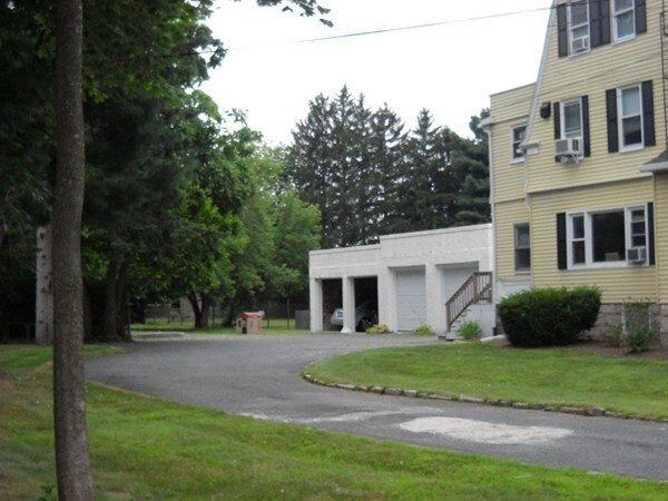
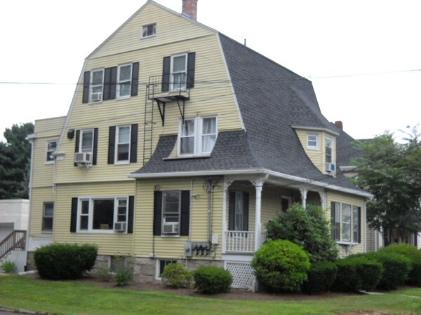
6 North St Unit 1
Milford, MA 01757
Today
Favorites
508-380-0491
-
Bedrooms
2
-
Bathrooms
1.5
-
Square Feet
1,000 sq ft
-
Available
Available Now
Highlights
- Medical Services
- Landscaped Professionally
- Wood Flooring
- Porch
- Whole House Vacuum System
- No Cooling
6 North St Unit 1

Favorites
About This Home
$2,000 deposit,
Available Now
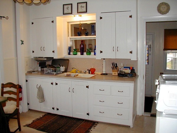
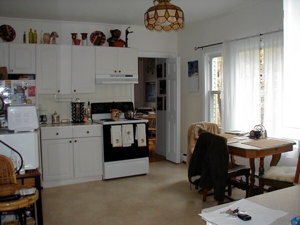
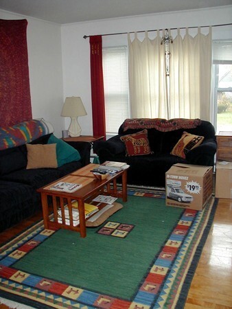
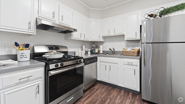
BEAUTIFUL FIRST FLOOR RENTAL. LARGE,EAT-IN KITCHEN WITH CEILING FAN,LOTS OF WOOD FLOORS,1.5 BATHS,1 CAR DETACHED GARAGE! DIRECT ACCESS TO COIN-OP LAUNDRY IN BASEMENT. NICE STORAGE AREA! CLOSE TO EXIT OFF OF RTE. 495,EASY OFF 109 NEAR OLIVA'S MARKET!
6 North St is an apartment community located in Worcester County and the 01757 ZIP Code.
* Price shown is base rent and may not include non-optional fees and utilities.
Price, availability, fees, and any applicable rent special are subject to change without notice.
* Square footage definitions vary. Displayed square footage is approximate.
Home Details
Year Built
Built in 1900
Accessible Home Design
Handicap Accessible
Entry on the 1st floor
Basement
Laundry in Basement
Bedrooms and Bathrooms
1.5 Bathrooms
2 Bedrooms
Eco-Friendly Details
Whole House Vacuum System
Home Design
Apartment
Interior Spaces
Wood Flooring
1-Story Property
1,000 Sq Ft Home
Kitchen
Range
Listing and Financial Details
Security Deposit $2,000
Property Available on 3/1/25
Assessor Parcel Number 1616588
Rent includes water, snow removal, occupancy only
Lot Details
0.51 Acre Lot
Landscaped Professionally
Outdoor Features
Porch
Parking
1 Car Garage
Utilities
No Cooling
Central Heating
Baseboard Heating
Heating System Uses Natural Gas
Internet Available
Community Details
Amenities
Medical Services
Laundry Facilities
Common Area
Overview
No Home Owners Association
Pet Policy
No Pets Allowed
Contact
- Listed by Kathleen Mehler | Appletree
- Phone Number
-
Source
 MLS Property Information Network
The property listing data and information set forth herein were provided to MLS Property Information Network, Inc. from third party sources, including sellers, lessors and public records, and were compiled by MLS Property Information Network, Inc. The property listing data and information are for the personal, non-commercial use of consumers having a good faith interest in purchasing or leasing listed properties of the type displayed to them and may not be used for any purpose other than to identify prospective properties which such consumers may have a good faith interest in purchasing or leasing. MLS Property Information Network, Inc. and its subscribers disclaim any and all representations and warranties as to the accuracy of the property listing data and information set forth herein. All properties are subject to prior sale, change or withdrawal. Copyright © 2025 MLS Property Information Network, Inc. All rights reserved.
Location
Get Directions
Amenities
- Vacuum System
- Wheelchair Accessible (Rooms)
- Range
- Refrigerator
- Porch
Forty miles southwest of Boston, Milford is a thriving town nestled amid the lush forests and rocky hills of Worcester County. Most of the community is made up of residential neighborhoods, with a broad variety of apartments and condos making up the majority of the local rental market. Main Street connects the timeless Downtown district’s vintage storefronts on the southwest side to the more modern shopping centers on the east side, forming the town’s main commercial corridor. Milford Pond serves as the centerpiece of the community, with Plains Park and Clark Island providing great venues for outdoor recreation including baseball diamonds and access to the Charles River Bike Trails.
Learn more about living in Milford
Education
| Colleges & Universities | Distance | ||
|---|---|---|---|
| Colleges & Universities | Distance | ||
| Drive: | 34 min | 16.0 mi | |
| Drive: | 31 min | 16.4 mi | |
| Drive: | 25 min | 17.2 mi | |
| Drive: | 31 min | 21.6 mi |
6 North St Unit 1 is within 25 minutes or 17.2 miles from Framingham State College. It is also near Tufts University, Grafton and Wellesley College.
Transportation options available in Milford include Riverside Station, located 28.3 miles from 6 North St Unit 1. 6 North St Unit 1 is near Worcester Regional, located 28.4 miles or 45 minutes away, and Rhode Island Tf Green International, located 34.7 miles or 54 minutes away.
| Transit / Subway | Distance | ||
|---|---|---|---|
| Transit / Subway | Distance | ||
|
|
Drive: | 38 min | 28.3 mi |
|
|
Drive: | 38 min | 28.6 mi |
|
|
Drive: | 39 min | 29.3 mi |
|
|
Drive: | 42 min | 30.9 mi |
|
|
Drive: | 42 min | 31.1 mi |
| Commuter Rail | Distance | ||
|---|---|---|---|
| Commuter Rail | Distance | ||
|
|
Drive: | 11 min | 7.0 mi |
|
|
Drive: | 13 min | 8.3 mi |
|
|
Drive: | 16 min | 9.9 mi |
|
|
Drive: | 22 min | 11.2 mi |
|
|
Drive: | 22 min | 11.2 mi |
| Airports | Distance | ||
|---|---|---|---|
| Airports | Distance | ||
|
Worcester Regional
|
Drive: | 45 min | 28.4 mi |
|
Rhode Island Tf Green International
|
Drive: | 54 min | 34.7 mi |
Time and distance from 6 North St Unit 1.
| Shopping Centers | Distance | ||
|---|---|---|---|
| Shopping Centers | Distance | ||
| Walk: | 7 min | 0.4 mi | |
| Walk: | 14 min | 0.7 mi | |
| Walk: | 17 min | 0.9 mi |
6 North St Unit 1 has 3 shopping centers within 0.9 mile, which is about a 17-minute walk. The miles and minutes will be for the farthest away property.
| Parks and Recreation | Distance | ||
|---|---|---|---|
| Parks and Recreation | Distance | ||
|
Mass Audubon's Waseeka Wildlife Sanctuary
|
Drive: | 18 min | 7.9 mi |
|
Blackstone River and Canal Heritage State Park
|
Drive: | 15 min | 8.0 mi |
|
Upton State Forest
|
Drive: | 15 min | 8.0 mi |
|
Whitehall State Park
|
Drive: | 23 min | 9.7 mi |
|
Ashland State Park
|
Drive: | 17 min | 10.2 mi |
6 North St Unit 1 has 5 parks within 10.2 miles, including Mass Audubon's Waseeka Wildlife Sanctuary, Upton State Forest, and Blackstone River and Canal Heritage State Park.
| Hospitals | Distance | ||
|---|---|---|---|
| Hospitals | Distance | ||
| Drive: | 3 min | 1.8 mi | |
| Drive: | 21 min | 12.6 mi |
6 North St Unit 1 is 1.8 miles from Milford Regional Medical Center, and is convenient to other hospitals, including Landmark Medical Center.
| Military Bases | Distance | ||
|---|---|---|---|
| Military Bases | Distance | ||
| Drive: | 30 min | 14.1 mi | |
| Drive: | 52 min | 36.4 mi |
6 North St Unit 1 is 14.1 miles from US Military Reservation, and is convenient to other military bases, including Hanscom Air Force Base.
You May Also Like
Similar Rentals Nearby


What Are Walk Score®, Transit Score®, and Bike Score® Ratings?
Walk Score® measures the walkability of any address. Transit Score® measures access to public transit. Bike Score® measures the bikeability of any address.
What is a Sound Score Rating?
A Sound Score Rating aggregates noise caused by vehicle traffic, airplane traffic and local sources
6 North St
Milford, MA 01757