$2,350 / Month
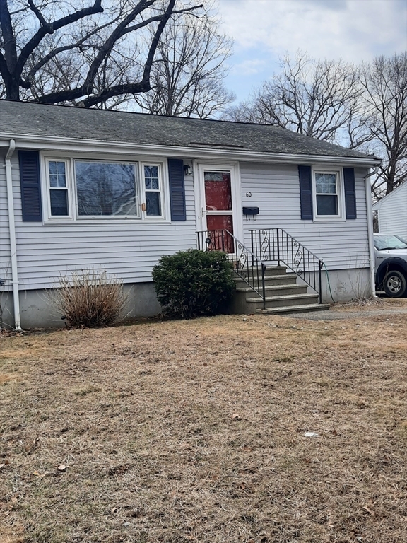
60 Willis Ave
Framingham, MA 01702
Today
Favorites
508-735-9994
-
Bedrooms
2
-
Bathrooms
1
-
Square Feet
800 sq ft
-
Available
Available Now
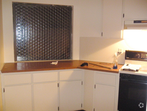
60 Willis Ave

Favorites
60 Willis Ave is a townhome located in Middlesex County and the 01702 ZIP Code. This area is served by the Framingham attendance zone.
* Price shown is base rent and may not include non-optional fees and utilities.
Price, availability, fees, and any applicable rent special are subject to change without notice.
* Square footage definitions vary. Displayed square footage is approximate.
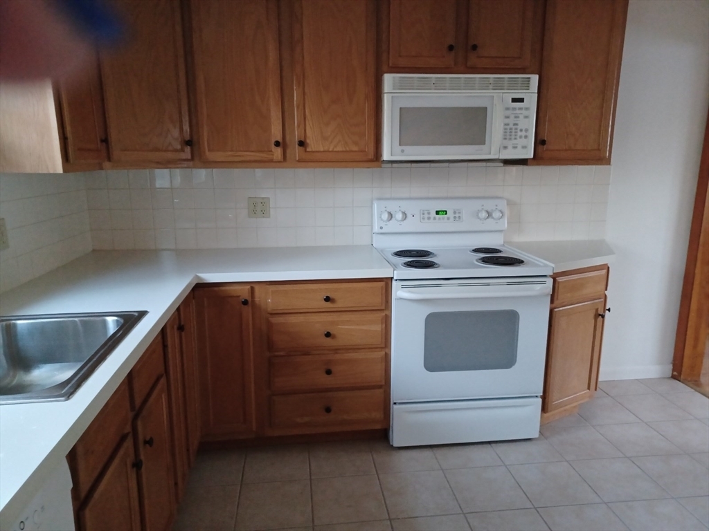
Townhome Features
- Dishwasher
- Disposal
- Refrigerator
Contact
- Listed by Lynn Norton | Robb Enterprises,LLC
- Phone Number (508) 735-9994
-
Source
 MLS Property Information Network
The property listing data and information set forth herein were provided to MLS Property Information Network, Inc. from third party sources, including sellers, lessors and public records, and were compiled by MLS Property Information Network, Inc. The property listing data and information are for the personal, non-commercial use of consumers having a good faith interest in purchasing or leasing listed properties of the type displayed to them and may not be used for any purpose other than to identify prospective properties which such consumers may have a good faith interest in purchasing or leasing. MLS Property Information Network, Inc. and its subscribers disclaim any and all representations and warranties as to the accuracy of the property listing data and information set forth herein. All properties are subject to prior sale, change or withdrawal. Copyright © 2025 MLS Property Information Network, Inc. All rights reserved.
$2,071 / month
$330,000 Listing Price
2 Beds
•1 Baths
•
712 Sq Ft
$2,609 / month
$420,000 Listing Price
3 Beds
•1.5 Baths
•
1,200 Sq Ft
$2,381 / month
$350,000 Listing Price
2 Beds
•1 Baths
•
1,858 Sq Ft
Location
Get Directions
Amenities
- Dishwasher
- Disposal
- Refrigerator
Just west of Boston and East of Worcester sits Metro West, a region that houses a group of towns and cities with significant historical backgrounds. A total of 19 municipalities make up the core of this community, but other municipalities are considered to be a part of the Interstate 495/Metro West Corridor.
Learn more about living in Metro West
Education
| Colleges & Universities | Distance | ||
|---|---|---|---|
| Colleges & Universities | Distance | ||
| Drive: | 8 min | 3.4 mi | |
| Drive: | 18 min | 7.7 mi | |
| Drive: | 20 min | 9.7 mi | |
| Drive: | 26 min | 14.1 mi |
60 Willis Ave is within 8 minutes or 3.4 miles from Framingham State College. It is also near Wellesley College and Babson College.
Schools
Public Elementary School
Grades K-5
696 Students
Attendance Zone
2
Out of 10
Public Elementary School
Grades K-5
496 Students
Attendance Zone
2
Out of 10
Public Elementary School
Grades PK-5
401 Students
Nearby
8
Out of 10
Public Middle School
Grades 6-8
616 Students
Attendance Zone
3
Out of 10
Public Middle School
Grades 6-8
789 Students
Attendance Zone
4
Out of 10
Public High School
Grades 9-12
2,566 Students
Attendance Zone
4
Out of 10
Private Elementary & Middle School
Grades PK-8
174 Students
Nearby
Private High School
Grades 9-12
227 Students
Nearby
School data provided by
GreatSchools
The GreatSchools Rating helps parents compare schools within a state based on a variety of school quality indicators and provides a helpful picture of how effectively each school serves all of its students. Ratings are on a scale of 1 (below average) to 10 (above average) and can include test scores, college readiness, academic progress, advanced courses, equity, discipline and attendance data. We also advise parents to visit schools, consider other information on school performance and programs, and consider family needs as part of the school selection process.
Transportation options available in Framingham include Woodland Station, located 12.3 miles from 60 Willis Ave. 60 Willis Ave is near General Edward Lawrence Logan International, located 26.2 miles or 41 minutes away, and Worcester Regional, located 27.6 miles or 49 minutes away.
| Transit / Subway | Distance | ||
|---|---|---|---|
| Transit / Subway | Distance | ||
|
|
Drive: | 22 min | 12.3 mi |
|
|
Drive: | 24 min | 13.0 mi |
|
|
Drive: | 23 min | 13.1 mi |
|
|
Drive: | 25 min | 13.6 mi |
|
|
Drive: | 25 min | 13.8 mi |
| Commuter Rail | Distance | ||
|---|---|---|---|
| Commuter Rail | Distance | ||
|
|
Drive: | 3 min | 1.4 mi |
|
|
Drive: | 3 min | 1.4 mi |
|
|
Drive: | 7 min | 2.8 mi |
|
|
Drive: | 14 min | 5.1 mi |
|
|
Drive: | 11 min | 5.2 mi |
| Airports | Distance | ||
|---|---|---|---|
| Airports | Distance | ||
|
General Edward Lawrence Logan International
|
Drive: | 41 min | 26.2 mi |
|
Worcester Regional
|
Drive: | 49 min | 27.6 mi |
Time and distance from 60 Willis Ave.
| Shopping Centers | Distance | ||
|---|---|---|---|
| Shopping Centers | Distance | ||
| Walk: | 8 min | 0.5 mi | |
| Walk: | 11 min | 0.6 mi | |
| Drive: | 3 min | 1.6 mi |
60 Willis Ave has 3 shopping centers within 1.6 miles, which is about a 3-minute walk. The miles and minutes will be for the farthest away property.
| Parks and Recreation | Distance | ||
|---|---|---|---|
| Parks and Recreation | Distance | ||
|
Mass Audubon's Waseeka Wildlife Sanctuary
|
Drive: | 12 min | 4.8 mi |
|
Ashland State Park
|
Drive: | 11 min | 5.1 mi |
|
Cowassock Woods and Ashland Town Forest
|
Drive: | 13 min | 5.3 mi |
|
Callahan State Park
|
Drive: | 12 min | 5.7 mi |
|
Wilfred J. Turenne Wildlife Habitat
|
Drive: | 14 min | 7.4 mi |
60 Willis Ave has 5 parks within 7.4 miles, including Ashland State Park, Mass Audubon's Waseeka Wildlife Sanctuary, and Cowassock Woods and Ashland Town Forest.
| Hospitals | Distance | ||
|---|---|---|---|
| Hospitals | Distance | ||
| Drive: | 4 min | 2.0 mi | |
| Drive: | 22 min | 11.6 mi | |
| Drive: | 24 min | 12.4 mi |
60 Willis Ave has 3 hospitals within 12.4 miles, the nearest is MetroWest Medical Center which is 2.0 miles away and a 4 minute drive.
| Military Bases | Distance | ||
|---|---|---|---|
| Military Bases | Distance | ||
| Drive: | 11 min | 5.2 mi | |
| Drive: | 37 min | 18.8 mi |
60 Willis Ave is 5.2 miles from US Military Reservation, and is convenient to other military bases, including Hanscom Air Force Base.
You May Also Like
Similar Rentals Nearby
-
-
-
-
-
 $6,0005 Beds, 1 Bath, 1,855 sq ftTownhome for Rent
 -
 $3,1003 Beds, 1 Bath, 1,277 sq ftTownhome for Rent
 -
 $4,2003 Beds, 2 Baths, 1,133 sq ftTownhome for Rent
 -
-
-
 $3,9753 Beds, 1.5 Baths, 1,800 sq ftTownhome for Rent


What Are Walk Score®, Transit Score®, and Bike Score® Ratings?
Walk Score® measures the walkability of any address. Transit Score® measures access to public transit. Bike Score® measures the bikeability of any address.
What is a Sound Score Rating?
A Sound Score Rating aggregates noise caused by vehicle traffic, airplane traffic and local sources

60 Willis Ave
Framingham, MA 01702