
$6,500 / Month
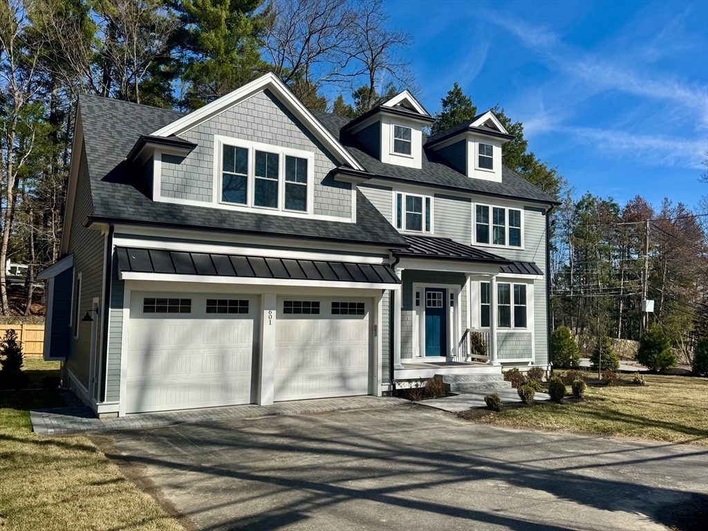
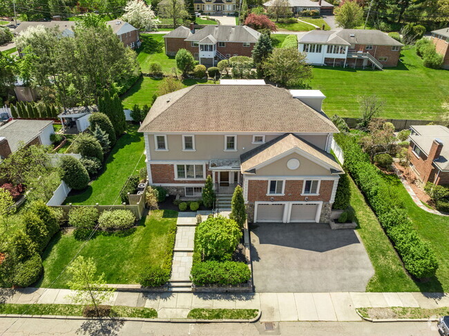
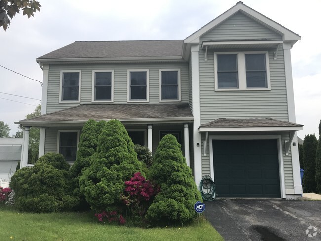
601 Salem End Rd
Framingham, MA 01702
Today
Favorites
508-989-0181
-
Bedrooms
4
-
Bathrooms
2.5
-
Square Feet
3,321 sq ft
-
Available
Available Now
Highlights
- Golf Course Community
- Community Stables
- Medical Services
- Custom Closet System
- Landscaped Professionally
- Property is near public transit
601 Salem End Rd

Favorites
About This Home
$6,500 deposit,
Available Now
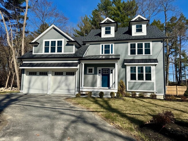
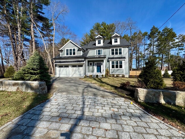
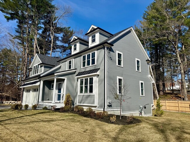
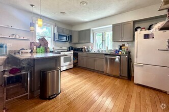
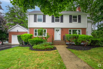
New Construction: Breathtaking Colonial Home featuring exquisite details & modern amenities for a luxurious & comfortable lifestyle. This meticulously crafted 10 room,2.5 bath home has 9 ft ceilings on the first floor,recessed lights,intricate crown molding & gleaming 4.5 inch wide hardwood flooring throughout the entire home. The kitchen is a chef's dream,enhanced with sleek quartz countertops,high-end Kitchen Aid appliances & custom cabinetry. Unwind in the family room with cozy gas fireplace & step outside to onto a composite landing with steps leading to a lower-level patio perfect for hosting guests. The spacious main suite boasts hardwood floors & a generous walk-in closet. Pamper yourself in the lavish main bath,complete with double vanity featuring quartz countertops,an oversized tiled shower 7 a separate soaking tub. Huge lower level unfinished. Stunning professionally landscaped grounds. Everything you ever wanted. Act quickly as the home is also listed for dale.
601 Salem End Rd is a house located in Middlesex County and the 01702 ZIP Code. This area is served by the Framingham attendance zone.
* Price shown is base rent and may not include non-optional fees and utilities.
Price, availability, fees, and any applicable rent special are subject to change without notice.
* Square footage definitions vary. Displayed square footage is approximate.
Home Details
Home Type
Single Family Detached Home
Year Built
Built in 2025
Accessible Home Design
Entry on the 1st floor
Bedrooms and Bathrooms
Custom Closet System
Soaking Tub
Linen Closet
Double Vanity
Bathtub with Shower
Primary bedroom located on second floor
Linen Closet In Bathroom
Separate Shower
Pedestal Sink
2.5 Bathrooms
4 Bedrooms
Flooring
Wood
Ceramic Tile
Interior Spaces
Loft
1 Fireplace
Bonus Room
Recessed Lighting
Window Screens
3,321 Sq Ft Home
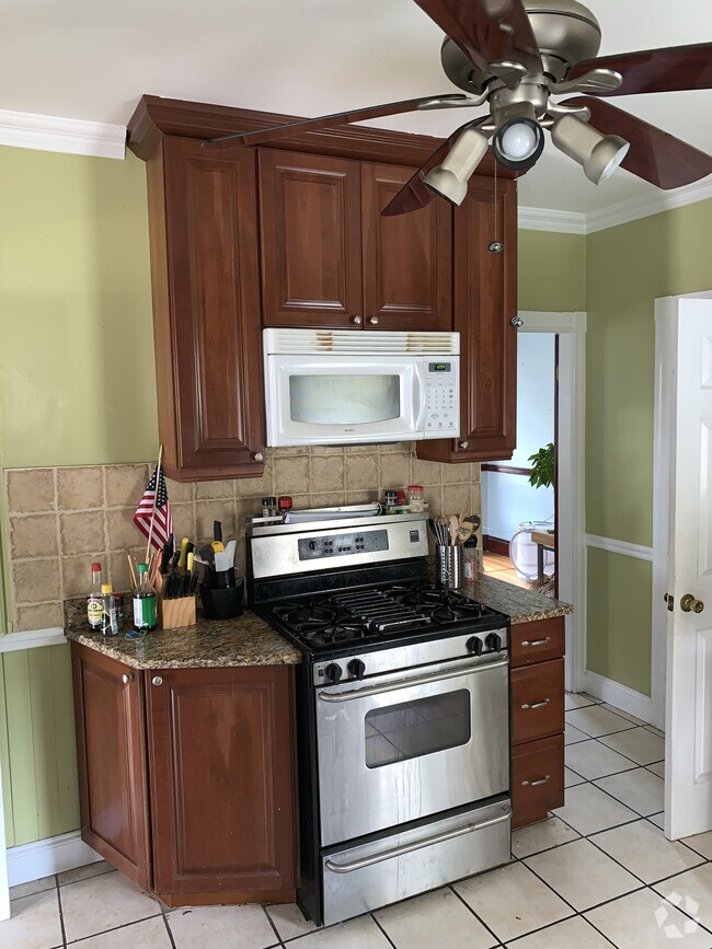
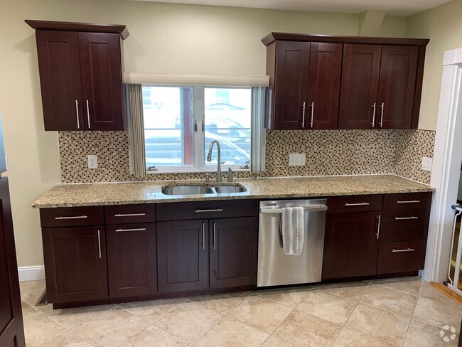
Kitchen
Solid Surface Countertops
ENERGY STAR Qualified Dishwasher
ENERGY STAR Qualified Refrigerator
Range
Oven
Microwave
Disposal
Laundry
Laundry on upper level
Dryer Hookup
Listing and Financial Details
Security Deposit $6,500
Assessor Parcel Number 507294
Rent includes trash collection, occupancy only
Location
Property is near public transit
Property is near schools
Lot Details
9,714 Sq Ft Lot
Landscaped Professionally
Near Conservation Area
Sprinkler System
Outdoor Features
Patio
Rain Gutters
Parking
2 Car Garage
Schools
School Choice Elementary And Middle School
Framingham High School
Utilities
Cooling Available
Forced Air Heating System
Heating System Uses Natural Gas
Internet Available
Community Details
Amenities
Medical Services
Shops
Laundry Facilities
Overview
No Home Owners Association
Pet Policy
No Pets Allowed
Recreation
Golf Course Community
Community Stables
Community Pool
Jogging Path
Park
Fees and Policies
The fees below are based on community-supplied data and may exclude additional fees and utilities.
Contact
- Listed by William Gath | Realty Executives Boston West
- Phone Number
-
Source
 MLS Property Information Network
The property listing data and information set forth herein were provided to MLS Property Information Network, Inc. from third party sources, including sellers, lessors and public records, and were compiled by MLS Property Information Network, Inc. The property listing data and information are for the personal, non-commercial use of consumers having a good faith interest in purchasing or leasing listed properties of the type displayed to them and may not be used for any purpose other than to identify prospective properties which such consumers may have a good faith interest in purchasing or leasing. MLS Property Information Network, Inc. and its subscribers disclaim any and all representations and warranties as to the accuracy of the property listing data and information set forth herein. All properties are subject to prior sale, change or withdrawal. Copyright © 2025 MLS Property Information Network, Inc. All rights reserved.
Location
Get Directions
Amenities
- Sprinkler System
- Disposal
- Microwave
- Range
- Patio
Just west of Boston and East of Worcester sits Metro West, a region that houses a group of towns and cities with significant historical backgrounds. A total of 19 municipalities make up the core of this community, but other municipalities are considered to be a part of the Interstate 495/Metro West Corridor.
Learn more about living in Metro West
Education
| Colleges & Universities | Distance | ||
|---|---|---|---|
| Colleges & Universities | Distance | ||
| Drive: | 4 min | 1.5 mi | |
| Drive: | 19 min | 10.0 mi | |
| Drive: | 20 min | 10.9 mi | |
| Drive: | 25 min | 13.3 mi |
601 Salem End Rd is within 4 minutes or 1.5 miles from Framingham State College. It is also near Wellesley College and Babson College.
Schools


Public Elementary School
Grades K-5
487 Students
Attendance Zone
Public Elementary School
Grades K-5
696 Students
Attendance Zone
Public Elementary School
Grades PK-1
350 Students
Nearby
Public Middle School
Grades 6-8
616 Students
Attendance Zone
Public Middle School
Grades 6-8
789 Students
Attendance Zone
Public High School
Grades 9-12
2,566 Students
Attendance Zone
Private Elementary & Middle School
Grades PK-8
54 Students
Nearby
Private Elementary School
Grades PK-6
83 Students
Nearby
Private High School
Grades 9-12
9 Students
Nearby
School data provided by
 The GreatSchools Rating helps parents compare schools within a state based on a variety of school quality indicators and provides a helpful picture of how effectively each school serves all of its students. Ratings are on a scale of 1 (below average) to 10 (above average) and can include test scores, college readiness, academic progress, advanced courses, equity, discipline and attendance data. We also advise parents to visit schools, consider other information on school performance and programs, and consider family needs as part of the school selection process.
View GreatSchools Rating Methodology
View GreatSchools Rating Methodology
Transportation options available in Framingham include Woodland Station, located 12.3 miles from 601 Salem End Rd. 601 Salem End Rd is near Worcester Regional, located 23.0 miles or 39 minutes away, and General Edward Lawrence Logan International, located 28.5 miles or 40 minutes away.
| Transit / Subway | Distance | ||
|---|---|---|---|
| Transit / Subway | Distance | ||
|
|
Drive: | 21 min | 12.3 mi |
|
|
Drive: | 23 min | 13.0 mi |
|
|
Drive: | 24 min | 13.6 mi |
|
|
Drive: | 24 min | 13.8 mi |
|
|
Drive: | 22 min | 15.4 mi |
| Commuter Rail | Distance | ||
|---|---|---|---|
| Commuter Rail | Distance | ||
|
|
Drive: | 8 min | 3.6 mi |
|
|
Drive: | 9 min | 3.6 mi |
|
|
Drive: | 13 min | 3.9 mi |
|
|
Drive: | 12 min | 4.9 mi |
|
|
Drive: | 10 min | 4.9 mi |
| Airports | Distance | ||
|---|---|---|---|
| Airports | Distance | ||
|
Worcester Regional
|
Drive: | 39 min | 23.0 mi |
|
General Edward Lawrence Logan International
|
Drive: | 40 min | 28.5 mi |
Time and distance from 601 Salem End Rd.
| Shopping Centers | Distance | ||
|---|---|---|---|
| Shopping Centers | Distance | ||
| Walk: | 20 min | 1.0 mi | |
| Drive: | 3 min | 1.3 mi | |
| Drive: | 4 min | 1.7 mi |
601 Salem End Rd has 3 shopping centers within 1.7 miles, which is about a 4-minute walk. The miles and minutes will be for the farthest away property.
| Parks and Recreation | Distance | ||
|---|---|---|---|
| Parks and Recreation | Distance | ||
|
Cowassock Woods and Ashland Town Forest
|
Walk: | 15 min | 0.8 mi |
|
Callahan State Park
|
Drive: | 7 min | 2.8 mi |
|
Wilfred J. Turenne Wildlife Habitat
|
Drive: | 5 min | 3.1 mi |
|
Ashland State Park
|
Drive: | 10 min | 3.9 mi |
|
Hop Brook Natural Area
|
Drive: | 9 min | 4.1 mi |
601 Salem End Rd has 5 parks within 4.1 miles, including Cowassock Woods and Ashland Town Forest, Wilfred J. Turenne Wildlife Habitat, and Callahan State Park.
| Hospitals | Distance | ||
|---|---|---|---|
| Hospitals | Distance | ||
| Drive: | 7 min | 2.9 mi | |
| Drive: | 14 min | 7.8 mi |
601 Salem End Rd is 2.9 miles from MetroWest Medical Center, and is convenient to other hospitals, including UMass Memorial Healthcare - Marlborough Hospital.
| Military Bases | Distance | ||
|---|---|---|---|
| Military Bases | Distance | ||
| Drive: | 12 min | 6.4 mi | |
| Drive: | 36 min | 19.0 mi |
601 Salem End Rd is 6.4 miles from US Military Reservation, and is convenient to other military bases, including Hanscom Air Force Base.
You May Also Like
Similar Rentals Nearby
What Are Walk Score®, Transit Score®, and Bike Score® Ratings?
Walk Score® measures the walkability of any address. Transit Score® measures access to public transit. Bike Score® measures the bikeability of any address.
What is a Sound Score Rating?
A Sound Score Rating aggregates noise caused by vehicle traffic, airplane traffic and local sources

601 Salem End Rd
Framingham, MA 01702