$3,500 / Month
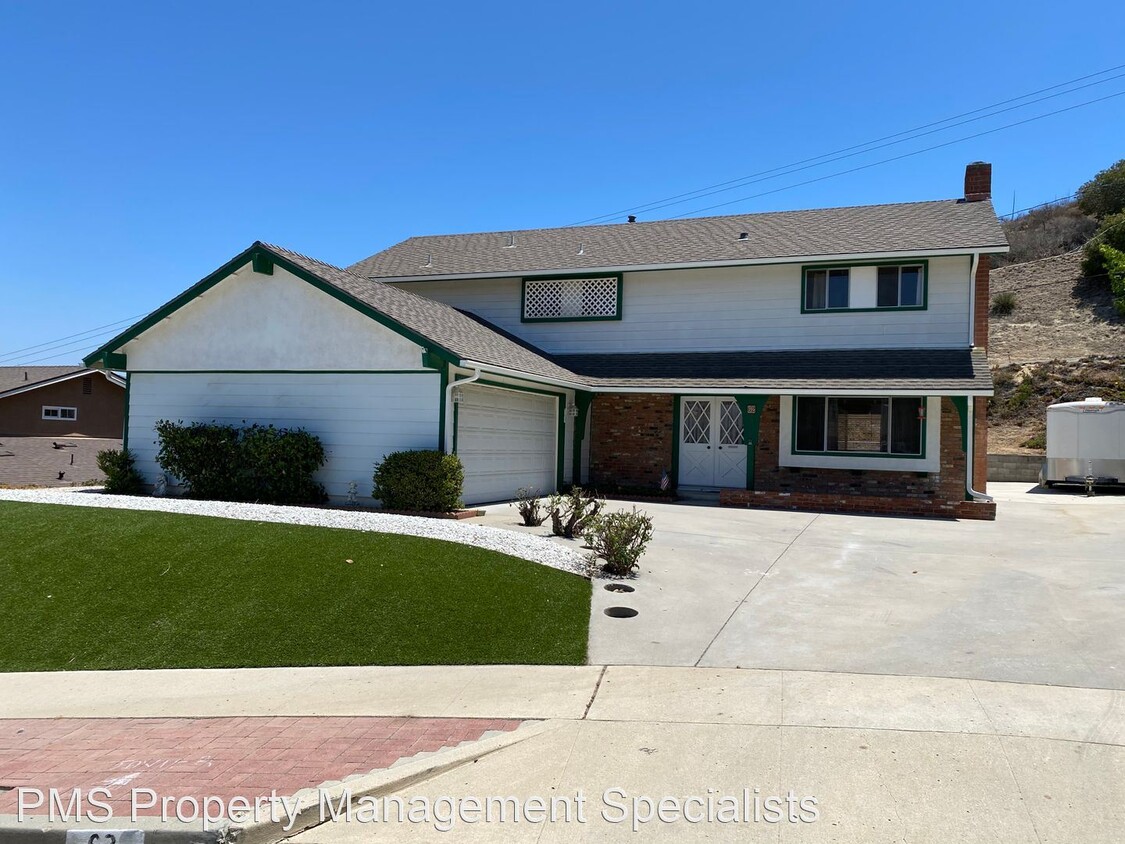
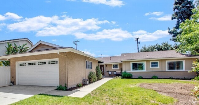
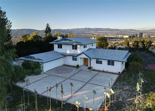
62 Robbins Ct
Simi Valley, CA 93065
2 Weeks Ago
Favorites
62 Robbins Ct

Favorites
Check Back Soon for Upcoming Availability
| Beds | Baths | Average SF |
|---|---|---|
| 4 Bedrooms 4 Bedrooms 4 Br | 3 Baths 3 Baths 3 Ba | 2,077 SF |
About This Property
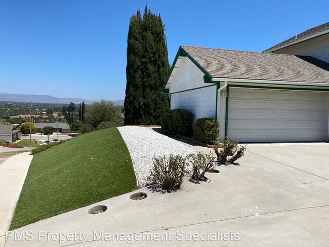
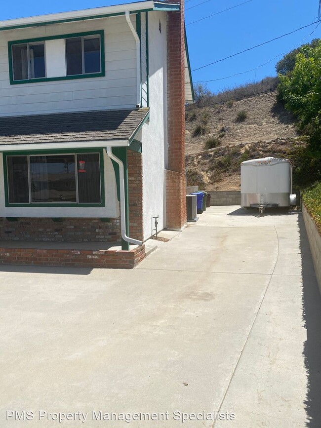
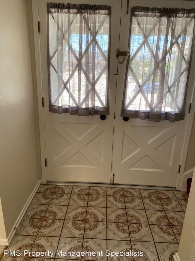
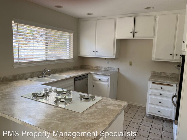
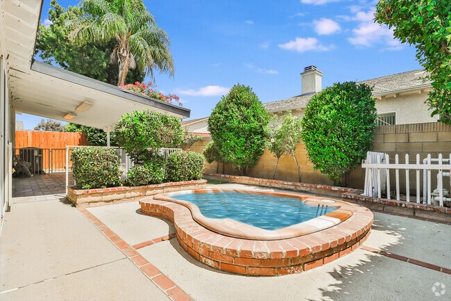
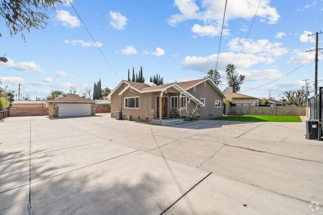
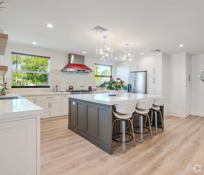
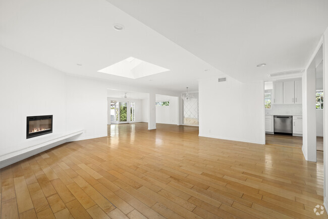
- 4 bed, 3 bath cul-de-sac home - First Time Rental! Light and bright. This spacious 4 bed, 3 bath 2 story home is located in a cul-de-sac on the West end of Simi Valley. The floorplan offers large living room with fireplace as well as open kitchen/dining/family room with slider to the back patio. Large drought tolerant front and backyard. Yard backs up to open space. Large side yard will accommodate RV. Pets will be considered with increased deposit. This secluded West Simi location is close to hiking trails, schools, shopping and restaurants yet miles away from the congestion. No smoking please. Available August 7th. (RLNE6762831) Pet policies: Small Dogs Allowed, Cats Allowed, Large Dogs Allowed.
62 Robbins Ct is a house located in Ventura County and the 93065 ZIP Code. This area is served by the Simi Valley Unified attendance zone.
Fees and Policies
The fees below are based on community-supplied data and may exclude additional fees and utilities.
- Dogs Allowed
-
Fees not specified
-
Weight limit--
-
Pet Limit--
Location
Get Directions
Situated in the southeastern portion of Ventura County, just north of Thousand Oaks, Simi Valley is a pristine suburb teeming with natural beauty. Simi Valley offers residents a host of recreational opportunities with 38 parks, three golf courses, and two swimming pools. Simi Valley is also adjacent to outdoor destinations like Rocky Peak Park, Santa Susana Pass State Historic Park, and Cheeseboro and Palo Comado Canyon.
The city provides plenty of modern delights in the form of diverse shopping and dining at its numerous strip malls and plazas, including Sycamore Square and Simi Valley Town Center. In addition to its many suburban offerings, Simi Valley is home to an array of specialty museums—the Ronald Reagan Presidential Library and Museum, Strathearn Historical Park and Museum, Santa Susana Depot Museum and Model Railroad, and the Skateboarding Hall of Fame and Museum. Getting around from Simi Valley is a breeze with convenience to the 118 freeway.
Learn more about living in Simi Valley
Education
| Colleges & Universities | Distance | ||
|---|---|---|---|
| Colleges & Universities | Distance | ||
| Drive: | 11 min | 5.6 mi | |
| Drive: | 13 min | 6.7 mi | |
| Drive: | 31 min | 21.0 mi | |
| Drive: | 33 min | 21.5 mi |
62 Robbins Ct is within 11 minutes or 5.6 miles from Moorpark College. It is also near California Lutheran University and Pierce College.
Schools


Public Elementary, Middle & High School
Grades K-12
345 Students
Nearby
Public Elementary School
Grades K-6
274 Students
Attendance Zone
Public Middle School
Grades 6-8
775 Students
Attendance Zone
Public High School
Grades 9-12
1,973 Students
Attendance Zone
Private Elementary School
Grades PK-1
20 Students
Nearby
Private Elementary, Middle & High School
Grades 1-12
Nearby
Private Elementary School
Grades K
Nearby
School data provided by
 The GreatSchools Rating helps parents compare schools within a state based on a variety of school quality indicators and provides a helpful picture of how effectively each school serves all of its students. Ratings are on a scale of 1 (below average) to 10 (above average) and can include test scores, college readiness, academic progress, advanced courses, equity, discipline and attendance data. We also advise parents to visit schools, consider other information on school performance and programs, and consider family needs as part of the school selection process.
View GreatSchools Rating Methodology
View GreatSchools Rating Methodology
Transportation options available in Simi Valley include North Hollywood Station, located 30.9 miles from 62 Robbins Ct. 62 Robbins Ct is near Bob Hope, located 30.0 miles or 39 minutes away, and Los Angeles International, located 45.9 miles or 59 minutes away.
| Transit / Subway | Distance | ||
|---|---|---|---|
| Transit / Subway | Distance | ||
|
|
Drive: | 38 min | 30.9 mi |
|
|
Drive: | 48 min | 39.2 mi |
|
|
Drive: | 50 min | 40.4 mi |
|
|
Drive: | 51 min | 40.9 mi |
|
|
Drive: | 51 min | 41.6 mi |
| Commuter Rail | Distance | ||
|---|---|---|---|
| Commuter Rail | Distance | ||
|
|
Drive: | 12 min | 6.6 mi |
|
|
Drive: | 12 min | 6.7 mi |
|
|
Drive: | 21 min | 15.1 mi |
|
|
Drive: | 27 min | 19.6 mi |
|
|
Drive: | 26 min | 19.7 mi |
| Airports | Distance | ||
|---|---|---|---|
| Airports | Distance | ||
|
Bob Hope
|
Drive: | 39 min | 30.0 mi |
|
Los Angeles International
|
Drive: | 59 min | 45.9 mi |
Time and distance from 62 Robbins Ct.
| Shopping Centers | Distance | ||
|---|---|---|---|
| Shopping Centers | Distance | ||
| Walk: | 9 min | 0.5 mi | |
| Walk: | 11 min | 0.6 mi | |
| Walk: | 17 min | 0.9 mi |
62 Robbins Ct has 3 shopping centers within 0.9 mile, which is about a 17-minute walk. The miles and minutes will be for the farthest away property.
| Parks and Recreation | Distance | ||
|---|---|---|---|
| Parks and Recreation | Distance | ||
|
Conejo Valley Botanic Garden
|
Drive: | 16 min | 9.2 mi |
|
Santa Monica Mountains National Recreation Area
|
Drive: | 18 min | 11.4 mi |
|
Sage Ranch
|
Drive: | 21 min | 12.7 mi |
|
Orcutt Ranch Horticultural Center
|
Drive: | 26 min | 16.1 mi |
|
Upper Las Virgenes Canyon Open Space Preserve
|
Drive: | 38 min | 20.6 mi |
62 Robbins Ct has 5 parks within 20.6 miles, including Conejo Valley Botanic Garden, Santa Monica Mountains National Recreation Area, and Sage Ranch.
| Hospitals | Distance | ||
|---|---|---|---|
| Hospitals | Distance | ||
| Drive: | 9 min | 5.0 mi | |
| Drive: | 14 min | 8.7 mi |
62 Robbins Ct is 5.0 miles from Adventist Health Simi Valley, and is convenient to other hospitals, including Los Robles Hospital & Medical Center.
| Military Bases | Distance | ||
|---|---|---|---|
| Military Bases | Distance | ||
| Drive: | 46 min | 27.8 mi |
62 Robbins Ct is 27.8 miles and a 46 minute drive from Point Mugu Naval Air Station.
You May Also Like
Similar Rentals Nearby

What Are Walk Score®, Transit Score®, and Bike Score® Ratings?
Walk Score® measures the walkability of any address. Transit Score® measures access to public transit. Bike Score® measures the bikeability of any address.
What is a Sound Score Rating?
A Sound Score Rating aggregates noise caused by vehicle traffic, airplane traffic and local sources

62 Robbins Ct
Simi Valley, CA 93065