


$3,950 / Month
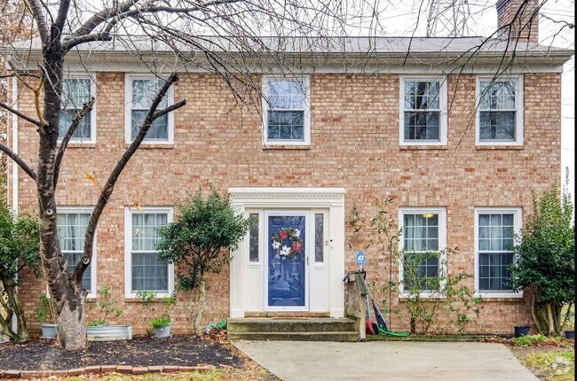
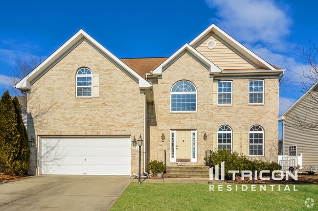
6259 Langston Blvd.
Arlington, VA 22205
2 Weeks Ago
Favorites
6259 Langston Blvd.

Favorites
Check Back Soon for Upcoming Availability
| Beds | Baths | Average SF |
|---|---|---|
| 4 Bedrooms 4 Bedrooms 4 Br | 3.5 Baths 3.5 Baths 3.5 Ba | 2,184 SF |
About This Property
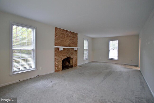
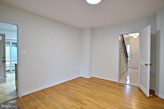
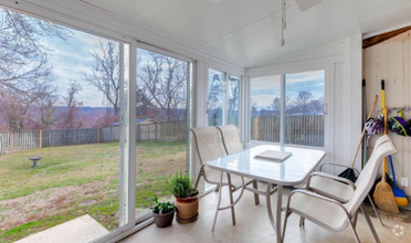
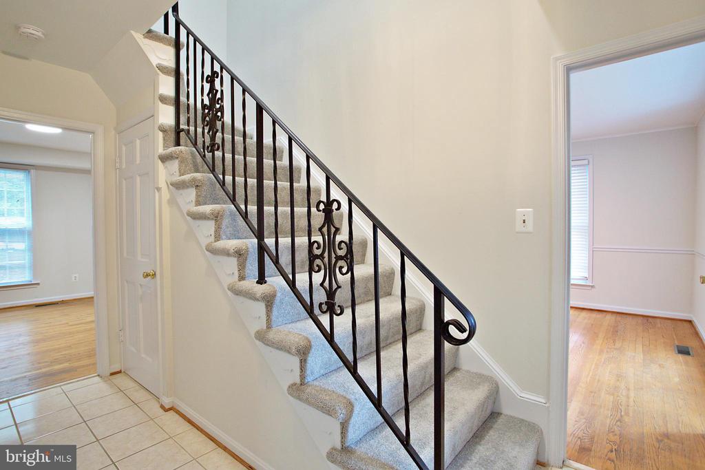
Discover this beautifully updated 3,200 sqft home nestled in the sought-after Williamsburg neighborhood of Arlington. The spacious and light-filled living areas provide a warm and welcoming atmosphere throughout. The bright kitchen, complete with a cozy breakfast nook, seamlessly flows into a sunny, separate dining room, perfect for entertaining. Step outside to the fenced-in patio, ideal for enjoying a quiet morning or a cup of coffee. Upstairs, the home boasts four generously-sized bedrooms and two full baths, including an updated primary ensuite designed for comfort and relaxation. Parking is a breeze with plenty of space available in the backyard. The location is unbeatable, with close proximity to top-rated schools like Nottingham Elementary, Williamsburg Middle, Yorktown High, and Bishop O’Connell High. Commute effortlessly with the East Falls Church Metro, I-66 entrance just a mile away, and easy access to Metro bus and the Custis Trail for biking, jogging, or walking. Enjoy the convenience of nearby parks, pools (Overlee, Yorktown indoor, and Columbus), as well as pharmacies, grocery stores, shopping, and an array of wonderful restaurants.
6259 Langston Blvd. is a house located in Arlington County and the 22205 ZIP Code. This area is served by the Arlington County Public Schools attendance zone.
House Features
- Fireplace
- Dishwasher
- Basement
Fees and Policies
Property Address:
6259 Langston Blvd.,
Arlington,
VA
22205
Situated in the western portion of Arlington, East Falls Church is a picturesque neighborhood brimming with upscale residences in a lush natural environment. Once dominated by dairy farms, East Falls Church offers many small-town comforts along with big-city convenience.
The neighborhood is home to a close-knit community and some of the area’s top-rated schools, many of which are within walking distance. Access to the Metrorail’s Orange and Silver lines places East Falls Church within minutes of the metropolitan delights of the Greater Washington, DC Area.
Several trails run through the neighborhood, providing residents with plenty of options for walking, biking, and enjoying the outdoors. Although East Falls Church is largely residential, numerous commercial conveniences are clustered at the intersection of I-66, Lee Highway, and Washington Boulevard.
Learn more about living in East Falls ChurchBelow are rent ranges for similar nearby apartments
Amenities
- Fireplace
- Dishwasher
- Basement
Education
| Colleges & Universities | Distance | ||
|---|---|---|---|
| Colleges & Universities | Distance | ||
| Drive: | 6 min | 2.1 mi | |
| Drive: | 8 min | 3.4 mi | |
| Drive: | 11 min | 5.3 mi | |
| Drive: | 13 min | 6.2 mi |
6259 Langston Blvd. is within 6 minutes or 2.1 miles from Marymount University. It is also near George Mason Univ., Arlington and NOVA, Alexandira Campus.
Schools


Public Elementary School
Grades PK-5
442 Students
Nearby
Public Elementary School
Grades PK-5
409 Students
Attendance Zone
Public Middle School
Grades 6-8
827 Students
Attendance Zone
Public High School
Grades 9-12
2,577 Students
Attendance Zone
Private Elementary & Middle School
Grades PK-8
200 Students
Nearby
Private Elementary & Middle School
Grades K-8
138 Students
Nearby
Private High School
Grades 9-12
1,193 Students
Nearby
School data provided by
 The GreatSchools Rating helps parents compare schools within a state based on a variety of school quality indicators and provides a helpful picture of how effectively each school serves all of its students. Ratings are on a scale of 1 (below average) to 10 (above average) and can include test scores, college readiness, academic progress, advanced courses, equity, discipline and attendance data. We also advise parents to visit schools, consider other information on school performance and programs, and consider family needs as part of the school selection process.
View GreatSchools Rating Methodology
View GreatSchools Rating Methodology
Transportation options available in Arlington include Ballston-Mu, located 3.1 miles from 6259 Langston Blvd.. 6259 Langston Blvd. is near Ronald Reagan Washington Ntl, located 10.6 miles or 18 minutes away, and Washington Dulles International, located 19.6 miles or 32 minutes away.
| Transit / Subway | Distance | ||
|---|---|---|---|
| Transit / Subway | Distance | ||
|
|
Drive: | 6 min | 3.1 mi |
|
|
Drive: | 7 min | 3.6 mi |
|
|
Drive: | 9 min | 4.1 mi |
|
|
Drive: | 9 min | 5.1 mi |
|
|
Drive: | 14 min | 8.0 mi |
| Commuter Rail | Distance | ||
|---|---|---|---|
| Commuter Rail | Distance | ||
|
|
Drive: | 20 min | 8.6 mi |
|
|
Drive: | 21 min | 8.7 mi |
|
|
Drive: | 15 min | 9.2 mi |
|
|
Drive: | 16 min | 9.3 mi |
|
|
Drive: | 18 min | 10.2 mi |
| Airports | Distance | ||
|---|---|---|---|
| Airports | Distance | ||
|
Ronald Reagan Washington Ntl
|
Drive: | 18 min | 10.6 mi |
|
Washington Dulles International
|
Drive: | 32 min | 19.6 mi |
Time and distance from 6259 Langston Blvd..
| Shopping Centers | Distance | ||
|---|---|---|---|
| Shopping Centers | Distance | ||
| Walk: | 13 min | 0.7 mi | |
| Walk: | 15 min | 0.8 mi | |
| Walk: | 16 min | 0.8 mi |
6259 Langston Blvd. has 3 shopping centers within 0.8 mile, which is about a 16-minute walk. The miles and minutes will be for the farthest away property.
| Parks and Recreation | Distance | ||
|---|---|---|---|
| Parks and Recreation | Distance | ||
|
W&OD Trail
|
Walk: | 14 min | 0.8 mi |
|
Benjamin Banneker Park
|
Walk: | 17 min | 0.9 mi |
|
Parkhurst Park
|
Walk: | 18 min | 1.0 mi |
|
Upton Hill Regional Park
|
Drive: | 5 min | 2.0 mi |
|
Rock Spring Park
|
Drive: | 4 min | 2.2 mi |
6259 Langston Blvd. has 5 parks within 2.2 miles, including W&OD Trail, Benjamin Banneker Park, and Parkhurst Park.
| Hospitals | Distance | ||
|---|---|---|---|
| Hospitals | Distance | ||
| Drive: | 4 min | 1.7 mi | |
| Drive: | 5 min | 1.9 mi | |
| Drive: | 5 min | 2.2 mi |
6259 Langston Blvd. has 3 hospitals within 2.2 miles, the nearest is Virginia Hospital Center which is 1.7 miles away and a 4 minute drive.
| Military Bases | Distance | ||
|---|---|---|---|
| Military Bases | Distance | ||
| Drive: | 13 min | 6.1 mi |
6259 Langston Blvd. is 6.1 miles and a 13 minute drive from Fort Myer.
You May Also Like
Similar Rentals Nearby


What Are Walk Score®, Transit Score®, and Bike Score® Ratings?
Walk Score® measures the walkability of any address. Transit Score® measures access to public transit. Bike Score® measures the bikeability of any address.
What is a Sound Score Rating?
A Sound Score Rating aggregates noise caused by vehicle traffic, airplane traffic and local sources
6259 Langston Blvd.
Arlington, VA 22205