

$3,450 / Month
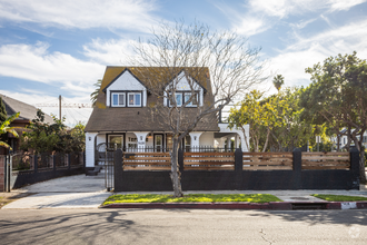
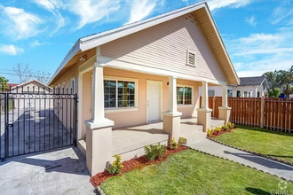
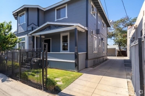
629 San Benito St
Los Angeles, CA 90033
2 Weeks Ago
Favorites
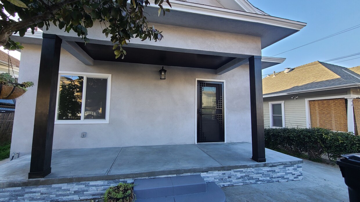
629 San Benito St

Favorites
Check Back Soon for Upcoming Availability
| Beds | Baths | Average SF |
|---|---|---|
| 3 Bedrooms 3 Bedrooms 3 Br | 1 Bath 1 Bath 1 Ba | 1,000 SF |
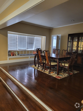
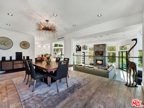
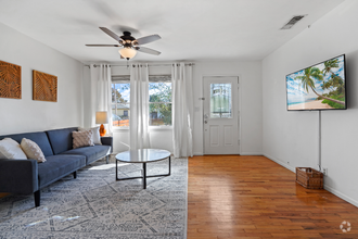
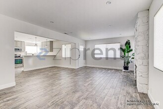
About This Property
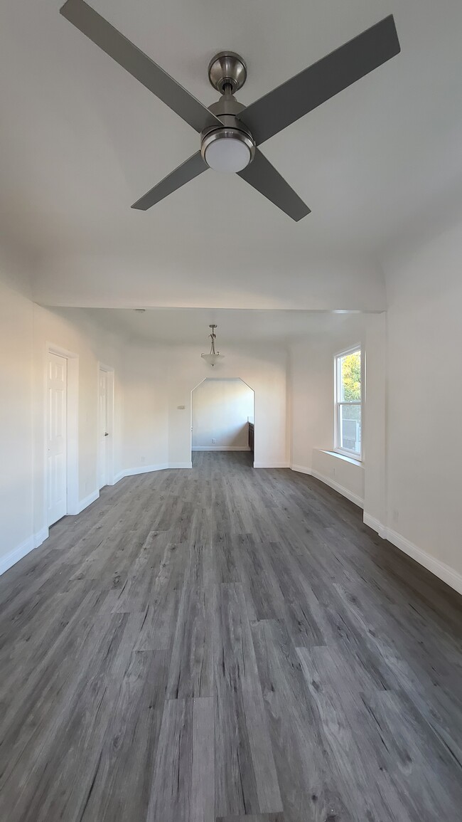
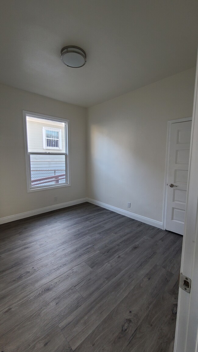
beautiful, single-family home. completely renovated. centrally located. close to parks, schools, train station, bus stop and all major freeways. Nice quiet neighborhood. Located on a cul-de-sac.
629 San Benito St is a house located in Los Angeles County and the 90033 ZIP Code.
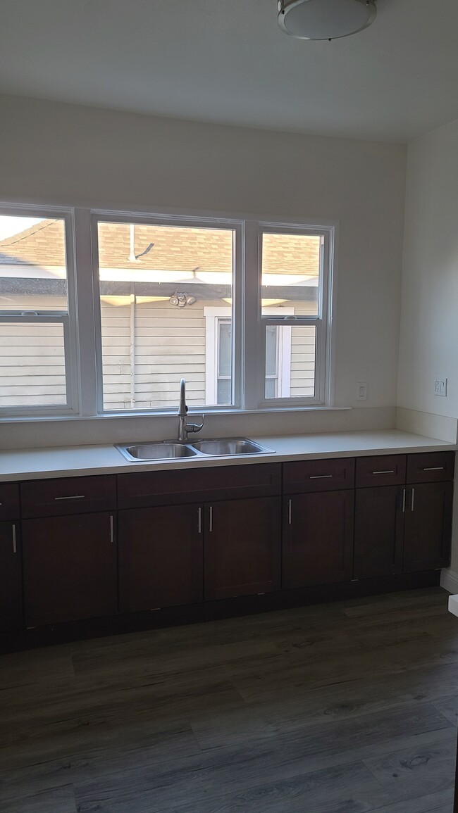
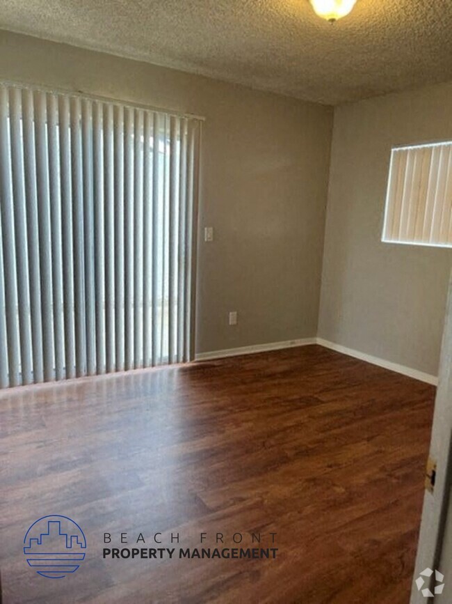
House Features
Granite Countertops
Microwave
Disposal
Stainless Steel Appliances
- Heating
- Ceiling Fans
- Smoke Free
- Disposal
- Granite Countertops
- Stainless Steel Appliances
- Kitchen
- Microwave
- Oven
- Range
- Vinyl Flooring
- Dining Room
- Bay Window
- Double Pane Windows
- Porch
- Yard
- Lawn
Fees and Policies
The fees below are based on community-supplied data and may exclude additional fees and utilities.
- Parking
-
Street--
Details
Utilities Included
-
Water
Property Address:
629 San Benito St,
Los Angeles,
CA
90033
Southeast Los Angeles is directly south of the Fashion District and east of the University of Southern California (USC). This large neighborhood is minutes from downtown Los Angeles, Hollywood, and Beverly Hills, with easy access to the 110 Freeway. This great location places you near sunny beaches, nature trails, and a bevy of leading employers. Students can access both USC and California State University Long Beach from their Southeast LA apartment.
This densely populated, diverse neighborhood features everything from food trucks and corner markets to wide sidewalks and residential areas filled with bungalows, ranch, and Spanish Colonial architecture. Southeast LA features palm trees and mountain views, tampered with gritty undertones to give it a cool, funky vibe.
As for outdoor fun, take your pick between Catalina Island, Venus Beach, or the Santa Monica Pier. Nearby, you’ll find more sunny beaches like White Point, Cabrillo, and Long Beach.
Learn more about living in Southeast Los AngelesBelow are rent ranges for similar nearby apartments
Amenities
- Heating
- Ceiling Fans
- Smoke Free
- Disposal
- Granite Countertops
- Stainless Steel Appliances
- Kitchen
- Microwave
- Oven
- Range
- Vinyl Flooring
- Dining Room
- Bay Window
- Double Pane Windows
- Porch
- Yard
- Lawn
Expenses
Utilities Included
Water
Included
Education
| Colleges & Universities | Distance | ||
|---|---|---|---|
| Colleges & Universities | Distance | ||
| Drive: | 4 min | 1.4 mi | |
| Drive: | 6 min | 3.4 mi | |
| Drive: | 7 min | 3.8 mi | |
| Drive: | 7 min | 3.8 mi |
629 San Benito St is within 4 minutes or 1.4 miles from USC, Health Sciences Campus. It is also near Cal State Los Angeles and Golden Gate Univ, Los Angeles.
Transportation options available in Los Angeles include Mariachi Plaza, located 0.7 mile from 629 San Benito St. 629 San Benito St is near Bob Hope, located 16.6 miles or 22 minutes away, and Los Angeles International, located 18.3 miles or 29 minutes away.
| Transit / Subway | Distance | ||
|---|---|---|---|
| Transit / Subway | Distance | ||
|
|
Walk: | 12 min | 0.7 mi |
|
|
Walk: | 14 min | 0.8 mi |
|
|
Drive: | 2 min | 1.1 mi |
|
|
Drive: | 5 min | 1.8 mi |
|
|
Drive: | 4 min | 1.9 mi |
| Commuter Rail | Distance | ||
|---|---|---|---|
| Commuter Rail | Distance | ||
|
|
Drive: | 6 min | 1.8 mi |
|
|
Drive: | 4 min | 1.9 mi |
| Drive: | 7 min | 5.9 mi | |
|
|
Drive: | 10 min | 6.5 mi |
|
|
Drive: | 13 min | 8.4 mi |
| Airports | Distance | ||
|---|---|---|---|
| Airports | Distance | ||
|
Bob Hope
|
Drive: | 22 min | 16.6 mi |
|
Los Angeles International
|
Drive: | 29 min | 18.3 mi |
Time and distance from 629 San Benito St.
| Shopping Centers | Distance | ||
|---|---|---|---|
| Shopping Centers | Distance | ||
| Walk: | 5 min | 0.3 mi | |
| Drive: | 3 min | 1.4 mi | |
| Drive: | 3 min | 1.8 mi |
629 San Benito St has 3 shopping centers within 1.8 miles, which is about a 3-minute drive. The miles and minutes will be for the farthest away property.
| Parks and Recreation | Distance | ||
|---|---|---|---|
| Parks and Recreation | Distance | ||
|
Hollenbeck Lake
|
Drive: | 3 min | 1.2 mi |
|
Vista Hermosa Natural Park
|
Drive: | 7 min | 3.5 mi |
|
Echo Park Lake
|
Drive: | 6 min | 3.6 mi |
|
Elysian Park
|
Drive: | 10 min | 4.1 mi |
|
Chavez Ravine Arboretum
|
Drive: | 7 min | 4.9 mi |
629 San Benito St has 5 parks within 4.9 miles, including Hollenbeck Lake, Vista Hermosa Natural Park, and Echo Park Lake.
| Hospitals | Distance | ||
|---|---|---|---|
| Hospitals | Distance | ||
| Walk: | 14 min | 0.8 mi | |
| Drive: | 4 min | 1.6 mi | |
| Drive: | 7 min | 3.4 mi |
629 San Benito St has 3 hospitals within 3.4 miles, the nearest is LAC + USC Medical Center which is 0.8 mile away and a 14 minutes drive.
| Military Bases | Distance | ||
|---|---|---|---|
| Military Bases | Distance | ||
| Drive: | 27 min | 19.5 mi |
629 San Benito St is 19.5 miles and a 27 minutes from Los Angeles Air Force Base.
You May Also Like
Similar Rentals Nearby
-
-
-
-
-
 $5,4003 Beds, 3 Baths, 1,285 sq ftHouse for Rent
 -
 $3,7503 Beds, 1 Bath, 1,243 sq ftHouse for Rent
 -
-
 $18,5004 Beds, 5 Baths, 5,420 sq ftHouse for Rent
 -
-
 $5,1003 Beds, 4 Baths, 1,765 sq ftHouse for Rent

What Are Walk Score®, Transit Score®, and Bike Score® Ratings?
Walk Score® measures the walkability of any address. Transit Score® measures access to public transit. Bike Score® measures the bikeability of any address.
What is a Sound Score Rating?
A Sound Score Rating aggregates noise caused by vehicle traffic, airplane traffic and local sources
629 San Benito St
Los Angeles, CA 90033