$2,800 / Month
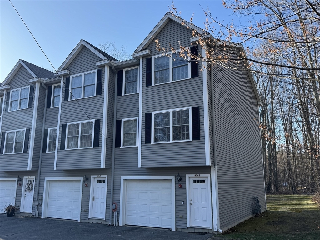
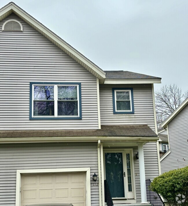
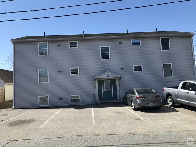
63 Shrine Ave Unit 4
West Boylston, MA 01583
Today
Favorites
774-261-3318
-
Bedrooms
2
-
Bathrooms
2.5
-
Square Feet
1,416 sq ft
-
Available
Available Now
Highlights
- Golf Course Community
- Community Stables
- Medical Services
- Deck
- Property is near public transit
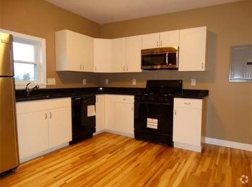
- Wood Flooring
63 Shrine Ave Unit 4

Favorites
About This Home
$2,800 deposit,
Available Now
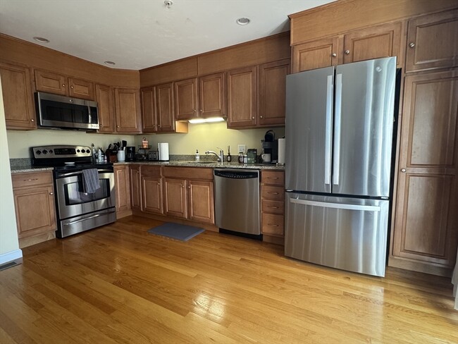
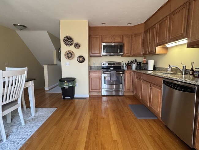
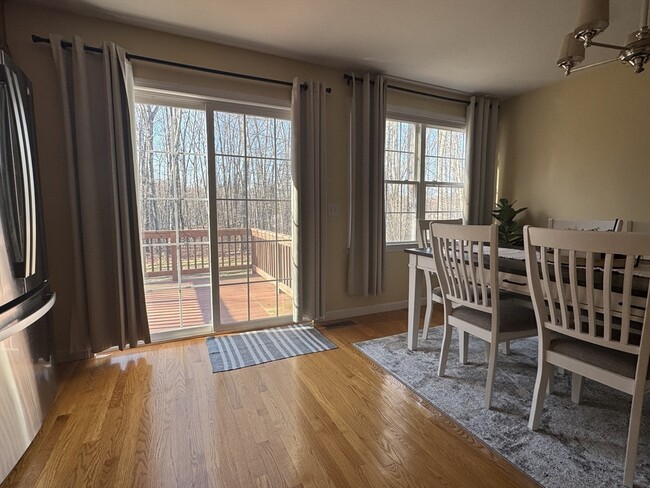
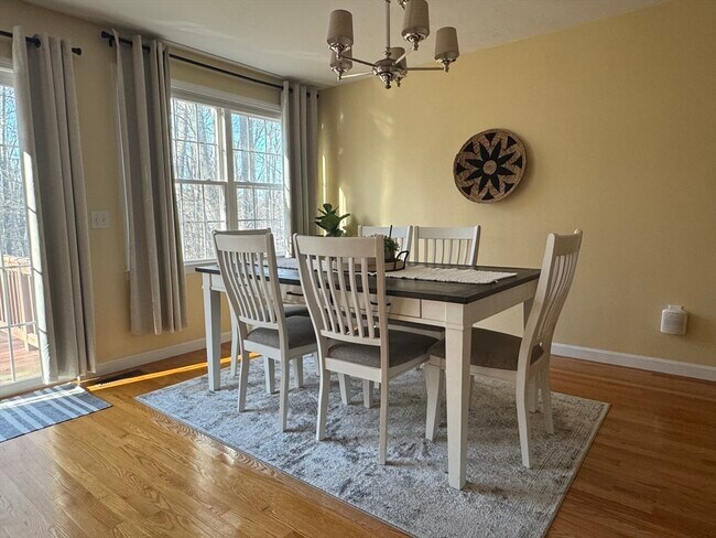
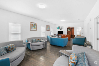
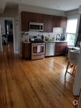
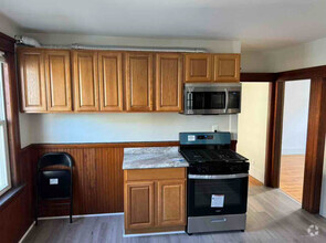
Welcome to this stunning end-unit townhome located in a quiet,walkable neighborhood. Built in 2007 and completely move-in ready,this bright and beautifully maintained home features 2 beds and 2.5 baths,offering the perfect blend of comfort and convenience. Enjoy the open and airy layout filled with natural light,gleaming hardwood floors on the first floor,and a cozy natural gas fireplace in the living room. Half bath with laundry (w/d included). 2nd floor features a generous sized primary suite with private full bath. Another good sized bedroom with ample closet space and a guest full bath. Additional features include in-unit laundry off of the first floor half bathroom,a modern kitchen & spacious dining room with slider access. Step outside to your private deck or take advantage of the shared,spacious backyard common area,ideal for relaxing or entertaining. Easy access to Routes 12 and 190,making commuting a breeze. This end unit offers both privacy & a prime location!
63 Shrine Ave is a condo located in Worcester County and the 01583 ZIP Code.
* Price shown is base rent and may not include non-optional fees and utilities.
Price, availability, fees, and any applicable rent special are subject to change without notice.
* Square footage definitions vary. Displayed square footage is approximate.
Home Details
Home Type
Condominium
Year Built
Built in 2007
Accessible Home Design
Entry on the 1st floor
Basement
Exterior Basement Entry
Bedrooms and Bathrooms
Primary bedroom located on second floor
2.5 Bathrooms
2 Bedrooms
Flooring
Wood
Ceramic Tile
Wall to Wall Carpet
Interior Spaces
Living Room with Fireplace
Sliding Doors
1,416 Sq Ft Home
Kitchen
Solid Surface Countertops
Range
Microwave
Dishwasher
Laundry
Dryer
Laundry on main level
Washer
Listing and Financial Details
Security Deposit $2,800
Property Available on 6/1/25
12 Month Lease Term
Assessor Parcel Number M:0163 B:0110 L:0004,4659550
Rent includes water, sewer, gardener
Location
Property is near public transit
Property is near schools
Lot Details
1 Acre Lot
Near Conservation Area
Outdoor Features
Deck
Balcony
Parking
2 Car Garage
Schools
Major Edwards Elementary School
Wbmhs Middle School
Wbmhs High School
Utilities
Cooling Available
Forced Air Heating System
Heating System Uses Natural Gas
Community Details
Amenities
Medical Services
Shops
Coin Laundry
Common Area
Overview
Property has a Home Owners Association
Pet Policy
No Pets Allowed
Recreation
Golf Course Community
Community Stables
Tennis Courts
Jogging Path
Park
Bike Trail
Fees and Policies
The fees below are based on community-supplied data and may exclude additional fees and utilities.
Contact
- Listed by Maria Troka | A & E Realty Company,Inc.
- Phone Number
-
Source
 MLS Property Information Network
The property listing data and information set forth herein were provided to MLS Property Information Network, Inc. from third party sources, including sellers, lessors and public records, and were compiled by MLS Property Information Network, Inc. The property listing data and information are for the personal, non-commercial use of consumers having a good faith interest in purchasing or leasing listed properties of the type displayed to them and may not be used for any purpose other than to identify prospective properties which such consumers may have a good faith interest in purchasing or leasing. MLS Property Information Network, Inc. and its subscribers disclaim any and all representations and warranties as to the accuracy of the property listing data and information set forth herein. All properties are subject to prior sale, change or withdrawal. Copyright © 2025 MLS Property Information Network, Inc. All rights reserved.
Location
Get Directions
Amenities
- Dishwasher
- Microwave
- Range
- Refrigerator
- Deck
Wrapped around the Wachusett Reservoir, West Boylston provides a classic New England setting complete with expansive, wooded areas, historic charm, and large homes. First settled in 1642 and incorporated in 1808, West Boylston is known as the “small town with a big heart.” Today, it is a popular suburb of Worcester, located directly south. Residents of West Boylston enjoy easy access to the University of Massachusetts Medical School, Quinsigamond Community College, and Tower Hill Botanic Garden.
If you believe classic New England is synonymous with the Farmer’s Almanac, then it’s worth noting that the founder and editor of the Farmer’s Almanac, Robert B. Thomas, lived in West Boylston. He started the Farmer’s Almanac in 1792, making it the oldest continuously published periodical in the country. Other historic locations include Bigelow Tavern, built in 1810; the Oakdale Village Historic District, dating back to 1780; and the Quinapoxet River Bridge, built in 1903.
Learn more about living in West Boylston
Education
| Colleges & Universities | Distance | ||
|---|---|---|---|
| Colleges & Universities | Distance | ||
| Drive: | 7 min | 2.9 mi | |
| Drive: | 12 min | 6.3 mi | |
| Drive: | 10 min | 6.3 mi | |
| Drive: | 15 min | 7.2 mi |
63 Shrine Ave Unit 4 is within 7 minutes or 2.9 miles from Quinsigamond Community College. It is also near Worcester Polytechnic Inst. and Assumption College.
Transportation options available in West Boylston include Riverside Station, located 39.6 miles from 63 Shrine Ave Unit 4. 63 Shrine Ave Unit 4 is near Worcester Regional, located 11.5 miles or 21 minutes away.
| Transit / Subway | Distance | ||
|---|---|---|---|
| Transit / Subway | Distance | ||
|
|
Drive: | 54 min | 39.6 mi |
|
|
Drive: | 54 min | 39.9 mi |
|
|
Drive: | 55 min | 40.6 mi |
|
|
Drive: | 58 min | 42.2 mi |
|
|
Drive: | 58 min | 42.4 mi |
| Commuter Rail | Distance | ||
|---|---|---|---|
| Commuter Rail | Distance | ||
|
|
Drive: | 11 min | 7.0 mi |
|
|
Drive: | 12 min | 7.1 mi |
|
|
Drive: | 23 min | 12.2 mi |
|
|
Drive: | 24 min | 13.0 mi |
|
|
Drive: | 22 min | 16.0 mi |
| Airports | Distance | ||
|---|---|---|---|
| Airports | Distance | ||
|
Worcester Regional
|
Drive: | 21 min | 11.5 mi |
Time and distance from 63 Shrine Ave Unit 4.
| Shopping Centers | Distance | ||
|---|---|---|---|
| Shopping Centers | Distance | ||
| Walk: | 5 min | 0.3 mi | |
| Walk: | 8 min | 0.4 mi | |
| Walk: | 13 min | 0.7 mi |
63 Shrine Ave Unit 4 has 3 shopping centers within 0.7 mile, which is about a 13-minute walk. The miles and minutes will be for the farthest away property.
| Parks and Recreation | Distance | ||
|---|---|---|---|
| Parks and Recreation | Distance | ||
|
Tower Hill Botanic Garden
|
Drive: | 11 min | 5.7 mi |
|
Quinsigamond State Park
|
Drive: | 13 min | 6.6 mi |
|
Mass Audubon's Eagle Lake Wildlife Sanctuary
|
Drive: | 15 min | 6.8 mi |
|
EcoTarium
|
Drive: | 16 min | 7.3 mi |
|
Mount Pisgah Conservation Area
|
Drive: | 23 min | 9.3 mi |
63 Shrine Ave Unit 4 has 5 parks within 9.3 miles, including Tower Hill Botanic Garden, Quinsigamond State Park, and Mass Audubon's Eagle Lake Wildlife Sanctuary.
| Hospitals | Distance | ||
|---|---|---|---|
| Hospitals | Distance | ||
| Drive: | 10 min | 6.1 mi | |
| Drive: | 13 min | 6.3 mi | |
| Drive: | 11 min | 6.7 mi |
63 Shrine Ave Unit 4 has 3 hospitals within 6.7 miles, the nearest is Adcare Hospital of Worcester which is 6.1 miles away and a 10 minute drive.
You May Also Like
Similar Rentals Nearby
-
-
-
-
-
-
-
 $3,0002 Beds, 1 Bath, 1,280 sq ftApartment for Rent
 -
-
-
What Are Walk Score®, Transit Score®, and Bike Score® Ratings?
Walk Score® measures the walkability of any address. Transit Score® measures access to public transit. Bike Score® measures the bikeability of any address.
What is a Sound Score Rating?
A Sound Score Rating aggregates noise caused by vehicle traffic, airplane traffic and local sources

63 Shrine Ave
West Boylston, MA 01583