

$4,365 / Month
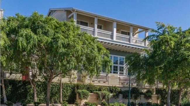
630 Bair Island Rd
Redwood City, CA 94063
2 Weeks Ago
Favorites
630 Bair Island Rd

Favorites
Check Back Soon for Upcoming Availability
| Beds | Baths | Average SF |
|---|---|---|
| 2 Bedrooms 2 Bedrooms 2 Br | 2 Baths 2 Baths 2 Ba | 1,533 SF |
About This Property
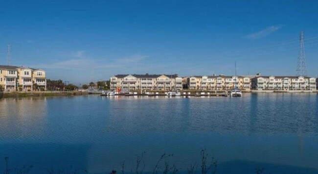
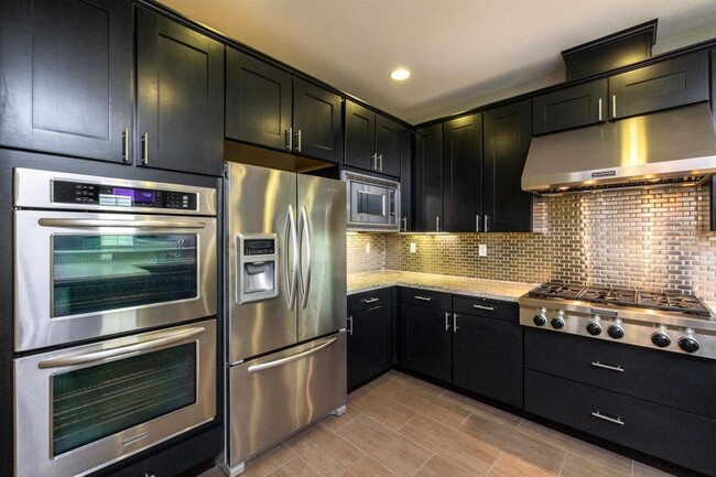
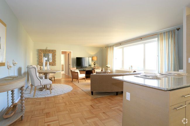
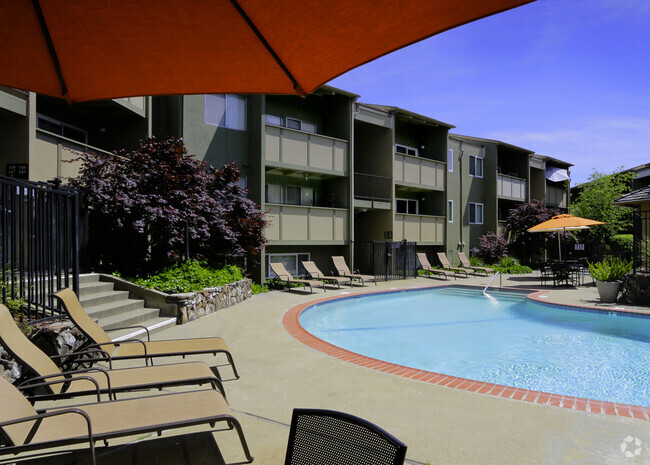
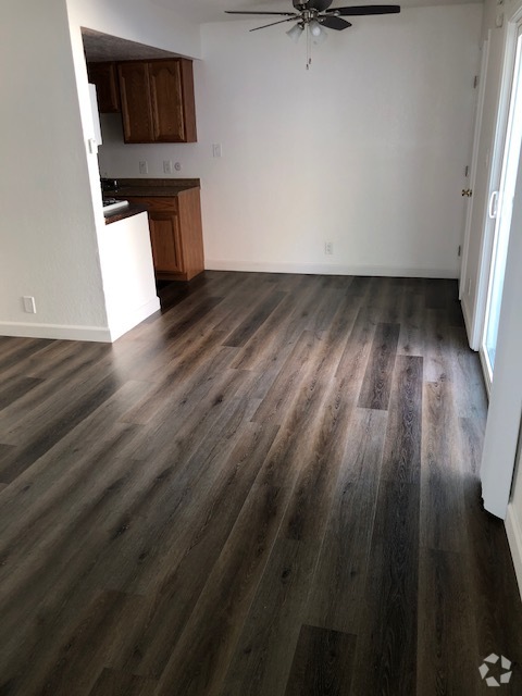
Unit 112 was the model unit when the complex was built. Every upgrade was added to this townhome. Open floor plan with open kitchen to living and dining areas plus a breakfast bar. New designer tied floors in kitchen, living and dining area. Master bedroom has two walk-in closets, double sinks in master bath and large tub with separate shower all tiled with designer selection. Large balcony off of main living area. You are minutes walk to the marina with access to the bay. The new completed underpass takes you downtown either by walking or biking. Owner will consider a lease with an option to purchase if the tenant so desires.
630 Bair Island Rd is a townhome located in San Mateo County and the 94063 ZIP Code. This area is served by the Redwood City Elementary attendance zone.
Location
Get Directions
Baylands is a neighborhood placed along the Bayshore Freeway in Redwood City, 27 miles south of San Francisco. This bayfront neighborhood has a plethora of outdoor activities provided by parks like Bair Island State Marine Park and Bedwell Bayfront Park, situated in the San Francisco Bay. Multiuse trails including Bike Trail Bair Island provide more outdoor recreation. For entertainment and great food, venture a little outside the neighborhood to Redwood City’s downtown to find restaurants and bars off Broadway and Main Street. Large shopping centers like Sequoia Station and Peninsula Boardwalk can be found in this area as well. Rental options in Baylands are mostly apartments in a range of styles and expected Bay Area prices.
Learn more about living in BaylandsBelow are rent ranges for similar nearby apartments
| Beds | Average Size | Lowest | Typical | Premium |
|---|---|---|---|---|
| Studio Studio Studio | 579 Sq Ft | $2,880 | $3,286 | $3,608 |
| 1 Bed 1 Bed 1 Bed | 735-736 Sq Ft | $1,200 | $3,689 | $6,930 |
| 2 Beds 2 Beds 2 Beds | 1160 Sq Ft | $2,925 | $5,155 | $8,980 |
| 3 Beds 3 Beds 3 Beds | 1433 Sq Ft | $6,160 | $6,654 | $9,331 |
| 4 Beds 4 Beds 4 Beds | 1570 Sq Ft | $4,990 | $5,793 | $7,000 |
Education
| Colleges & Universities | Distance | ||
|---|---|---|---|
| Colleges & Universities | Distance | ||
| Drive: | 12 min | 4.7 mi | |
| Drive: | 15 min | 5.6 mi | |
| Drive: | 14 min | 9.3 mi | |
| Drive: | 21 min | 11.8 mi |
630 Bair Island Rd is within 12 minutes or 4.7 miles from Menlo College. It is also near Canada College and Stanford University.
Schools


Public Elementary School
Grades K-5
Nearby
Public Elementary School
Grades K-5
354 Students
Attendance Zone
Public Middle School
Grades 6-8
706 Students
Attendance Zone
Public High School
Grades 9-12
1,909 Students
Attendance Zone
Private Elementary, Middle & High School
Grades K-12
33 Students
Nearby
Private Elementary & Middle School
Grades PK-8
Nearby
School data provided by
 The GreatSchools Rating helps parents compare schools within a state based on a variety of school quality indicators and provides a helpful picture of how effectively each school serves all of its students. Ratings are on a scale of 1 (below average) to 10 (above average) and can include test scores, college readiness, academic progress, advanced courses, equity, discipline and attendance data. We also advise parents to visit schools, consider other information on school performance and programs, and consider family needs as part of the school selection process.
View GreatSchools Rating Methodology
View GreatSchools Rating Methodology
Transportation options available in Redwood City include Millbrae Bart Station, located 12.7 miles from 630 Bair Island Rd. 630 Bair Island Rd is near San Francisco International, located 13.7 miles or 19 minutes away, and Metro Oakland International, located 29.4 miles or 38 minutes away.
| Transit / Subway | Distance | ||
|---|---|---|---|
| Transit / Subway | Distance | ||
|
|
Drive: | 18 min | 12.7 mi |
|
|
Drive: | 18 min | 13.3 mi |
|
|
Drive: | 18 min | 13.6 mi |
|
|
Drive: | 19 min | 13.8 mi |
|
|
Drive: | 19 min | 13.8 mi |
| Commuter Rail | Distance | ||
|---|---|---|---|
| Commuter Rail | Distance | ||
| Drive: | 4 min | 1.5 mi | |
| Drive: | 6 min | 3.1 mi | |
| Drive: | 7 min | 4.2 mi | |
| Drive: | 13 min | 5.2 mi | |
| Drive: | 15 min | 7.8 mi |
| Airports | Distance | ||
|---|---|---|---|
| Airports | Distance | ||
|
San Francisco International
|
Drive: | 19 min | 13.7 mi |
|
Metro Oakland International
|
Drive: | 38 min | 29.4 mi |
Time and distance from 630 Bair Island Rd.
| Shopping Centers | Distance | ||
|---|---|---|---|
| Shopping Centers | Distance | ||
| Walk: | 9 min | 0.5 mi | |
| Drive: | 5 min | 1.5 mi | |
| Drive: | 5 min | 1.7 mi |
630 Bair Island Rd has 3 shopping centers within 1.7 miles, which is about a 5-minute walk. The miles and minutes will be for the farthest away property.
| Parks and Recreation | Distance | ||
|---|---|---|---|
| Parks and Recreation | Distance | ||
|
Red Morton Park
|
Drive: | 9 min | 2.9 mi |
|
Edgewood Park & Natural Preserve
|
Drive: | 11 min | 4.0 mi |
|
Stulsaft Park
|
Drive: | 11 min | 4.2 mi |
|
Bayfront Park
|
Drive: | 10 min | 4.6 mi |
|
Holbrook-Palmer Park
|
Drive: | 11 min | 5.5 mi |
630 Bair Island Rd has 5 parks within 5.5 miles, including Red Morton Park, Stulsaft Park, and Holbrook-Palmer Park.
| Hospitals | Distance | ||
|---|---|---|---|
| Hospitals | Distance | ||
| Drive: | 4 min | 1.4 mi | |
| Drive: | 7 min | 2.2 mi | |
| Drive: | 12 min | 6.6 mi |
630 Bair Island Rd has 3 hospitals within 6.6 miles, the nearest is Kaiser Foundation Hospital - Redwood City which is 1.4 miles away and a 4 minute drive.
| Military Bases | Distance | ||
|---|---|---|---|
| Military Bases | Distance | ||
| Drive: | 21 min | 13.6 mi |
630 Bair Island Rd is 13.6 miles and a 21 minute drive from Ames Research Center.
You May Also Like
Similar Rentals Nearby


What Are Walk Score®, Transit Score®, and Bike Score® Ratings?
Walk Score® measures the walkability of any address. Transit Score® measures access to public transit. Bike Score® measures the bikeability of any address.
What is a Sound Score Rating?
A Sound Score Rating aggregates noise caused by vehicle traffic, airplane traffic and local sources
630 Bair Island Rd
Redwood City, CA 94063