$3,200 / Month
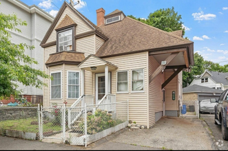
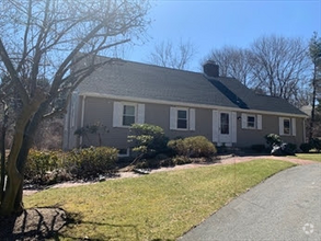
65 Bond St
Marlborough, MA 01752
2 Weeks Ago
Favorites
65 Bond St

Favorites
Check Back Soon for Upcoming Availability
| Beds | Baths | Average SF |
|---|---|---|
| 4 Bedrooms 4 Bedrooms 4 Br | 1 Bath 1 Bath 1 Ba | 2,136 SF |
About This Property
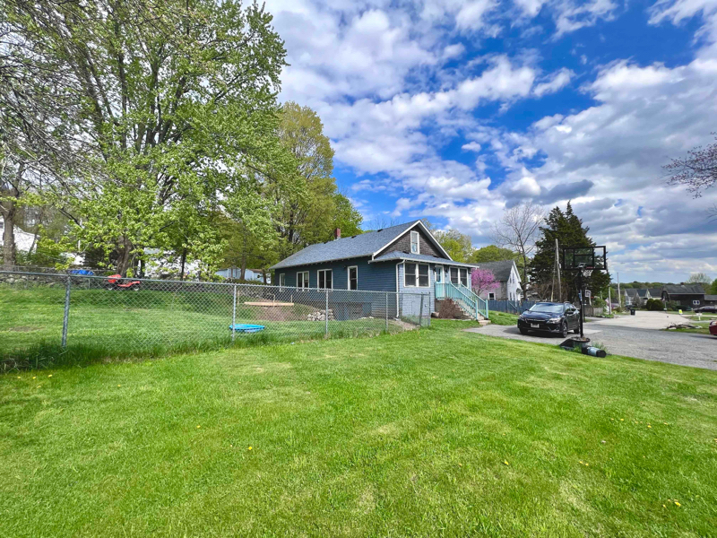
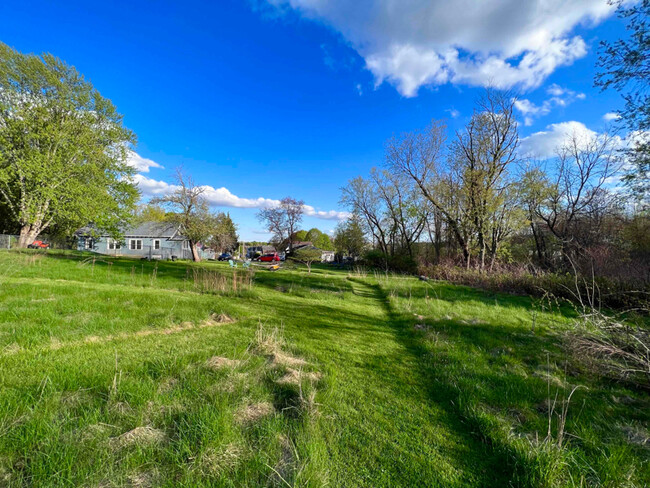
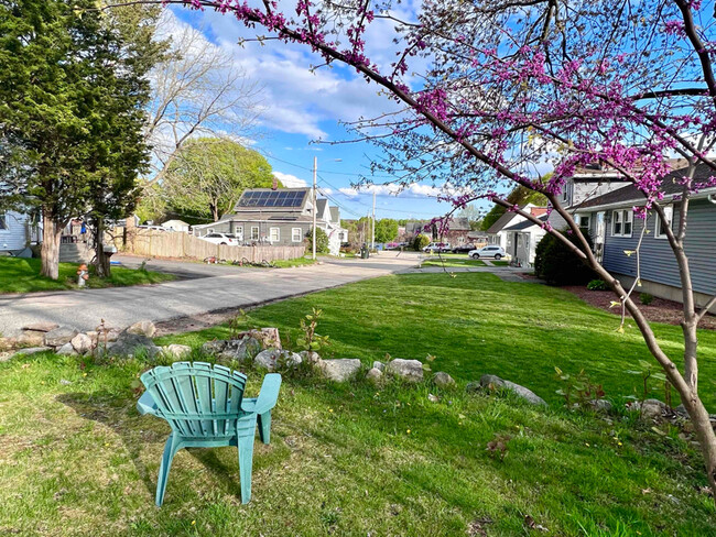
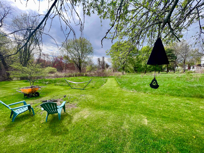
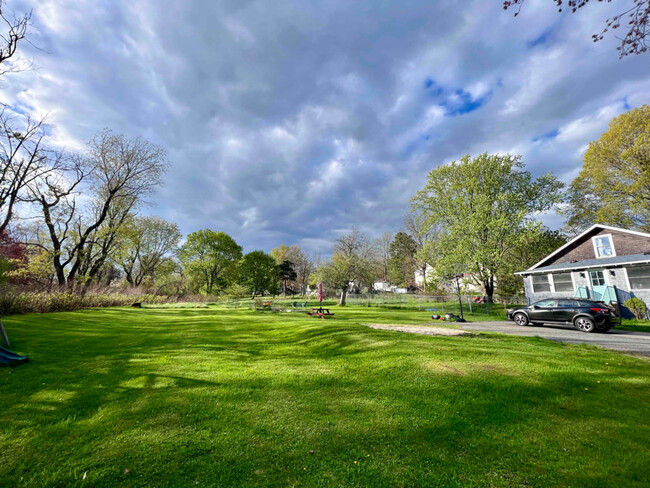
Property Id: 1179659 Enjoy the best of outdoor recreation in this spacious, pet-friendly house located at the end of a quiet dead-end road. This charming, sunlit home features hardwood floors, a large open concept living room, dining room, and and kitchen. The backyard is a dream come true for nature and animal lovers, with 1 acre of grassland to explore, play, or relax. The house is conveniently located in the center of Mass, making it a commuter's dream. 45 min to Boston, 25 min to Worcester. Next to 495, Route 20, Route 9, and the Mass Pike. Don't miss this opportunity to live in home that feels secluded, but still in the middle of it all. Available from July 1st. $3,300/month, 1 month security deposit. Utilities not included. Applicants must complete a rental application and authorize a $39 credit and background check. Indoor photos coming soon. For more info call Ruben at ??.
65 Bond St is a house located in Middlesex County and the 01752 ZIP Code. This area is served by the Marlborough attendance zone.
House Features
Washer/Dryer
Dishwasher
Hardwood Floors
Refrigerator
- Washer/Dryer
- Cable Ready
- Dishwasher
- Disposal
- Oven
- Refrigerator
- Hardwood Floors
- Vinyl Flooring
- Bicycle Storage
- Fenced Lot
- Lawn
Fees and Policies
The fees below are based on community-supplied data and may exclude additional fees and utilities.
- Dogs Allowed
-
Fees not specified
- Cats Allowed
-
Fees not specified
Details
Utilities Included
-
Water
-
Trash Removal
-
Sewer
Location
Get Directions
Just west of Boston and East of Worcester sits Metro West, a region that houses a group of towns and cities with significant historical backgrounds. A total of 19 municipalities make up the core of this community, but other municipalities are considered to be a part of the Interstate 495/Metro West Corridor.
Learn more about living in Metro WestBelow are rent ranges for similar nearby apartments
| Beds | Average Size | Lowest | Typical | Premium |
|---|---|---|---|---|
| Studio Studio Studio | 523-526 Sq Ft | $895 | $2,485 | $6,803 |
| 1 Bed 1 Bed 1 Bed | 792-793 Sq Ft | $1,400 | $3,020 | $10,781 |
| 2 Beds 2 Beds 2 Beds | 1159-1161 Sq Ft | $1,850 | $3,650 | $15,521 |
| 3 Beds 3 Beds 3 Beds | 1599-1604 Sq Ft | $2,190 | $5,040 | $21,502 |
| 4 Beds 4 Beds 4 Beds | 3584 Sq Ft | $1,050 | $6,342 | $20,000 |
Amenities
- Washer/Dryer
- Cable Ready
- Dishwasher
- Disposal
- Oven
- Refrigerator
- Hardwood Floors
- Vinyl Flooring
- Fenced Lot
- Lawn
- Bicycle Storage
Expenses
Utilities Included
Water, Trash Removal, Sewer
Included
Education
| Colleges & Universities | Distance | ||
|---|---|---|---|
| Colleges & Universities | Distance | ||
| Drive: | 18 min | 9.2 mi | |
| Drive: | 22 min | 12.1 mi | |
| Drive: | 21 min | 14.9 mi | |
| Drive: | 24 min | 17.2 mi |
65 Bond St is within 18 minutes or 9.2 miles from Framingham State College. It is also near Tufts University, Grafton and Stillman College.
Schools


Public Elementary School
Grades PK-4
430 Students
Nearby
Public Elementary School
Grades K-5
533 Students
Nearby
Public Middle School
Grades 6-8
1,044 Students
Nearby
Charter Middle & High School
Grades 6-12
966 Students
Nearby
Public High School
Grades 9-12
1,064 Students
Attendance Zone
Private Elementary & Middle School
Grades PK-8
90 Students
Nearby
Private Elementary & Middle School
Grades K-8
Nearby
Private Middle & High School
Grades 7-12
27 Students
Nearby
School data provided by
 The GreatSchools Rating helps parents compare schools within a state based on a variety of school quality indicators and provides a helpful picture of how effectively each school serves all of its students. Ratings are on a scale of 1 (below average) to 10 (above average) and can include test scores, college readiness, academic progress, advanced courses, equity, discipline and attendance data. We also advise parents to visit schools, consider other information on school performance and programs, and consider family needs as part of the school selection process.
View GreatSchools Rating Methodology
View GreatSchools Rating Methodology
Transportation options available in Marlborough include Riverside Station, located 21.1 miles from 65 Bond St. 65 Bond St is near Worcester Regional, located 21.4 miles or 32 minutes away, and General Edward Lawrence Logan International, located 34.2 miles or 51 minutes away.
| Transit / Subway | Distance | ||
|---|---|---|---|
| Transit / Subway | Distance | ||
|
|
Drive: | 33 min | 21.1 mi |
|
|
Drive: | 33 min | 21.4 mi |
|
|
Drive: | 34 min | 22.1 mi |
|
|
Drive: | 37 min | 23.7 mi |
|
|
Drive: | 37 min | 23.9 mi |
| Commuter Rail | Distance | ||
|---|---|---|---|
| Commuter Rail | Distance | ||
|
|
Drive: | 15 min | 8.9 mi |
|
|
Drive: | 16 min | 10.3 mi |
|
|
Drive: | 25 min | 10.7 mi |
|
|
Drive: | 23 min | 11.3 mi |
|
|
Drive: | 21 min | 13.4 mi |
| Airports | Distance | ||
|---|---|---|---|
| Airports | Distance | ||
|
Worcester Regional
|
Drive: | 32 min | 21.4 mi |
|
General Edward Lawrence Logan International
|
Drive: | 51 min | 34.2 mi |
Time and distance from 65 Bond St.
| Shopping Centers | Distance | ||
|---|---|---|---|
| Shopping Centers | Distance | ||
| Walk: | 16 min | 0.9 mi | |
| Drive: | 3 min | 1.4 mi | |
| Drive: | 4 min | 1.8 mi |
65 Bond St has 3 shopping centers within 1.8 miles, which is about a 4-minute walk. The miles and minutes will be for the farthest away property.
| Parks and Recreation | Distance | ||
|---|---|---|---|
| Parks and Recreation | Distance | ||
|
Felton Conservation Area
|
Drive: | 4 min | 1.7 mi |
|
Cedar Hill and Sawink Farm Reservation
|
Drive: | 11 min | 4.5 mi |
|
Wilfred J. Turenne Wildlife Habitat
|
Drive: | 12 min | 5.9 mi |
|
Walkup And Robinson Memorial Reservation
|
Drive: | 10 min | 6.4 mi |
|
Mount Pisgah Conservation Area
|
Drive: | 19 min | 9.7 mi |
65 Bond St has 5 parks within 9.7 miles, including Felton Conservation Area, Cedar Hill and Sawink Farm Reservation, and Wilfred J. Turenne Wildlife Habitat.
| Hospitals | Distance | ||
|---|---|---|---|
| Hospitals | Distance | ||
| Drive: | 3 min | 1.4 mi | |
| Drive: | 21 min | 10.6 mi |
65 Bond St is 1.4 miles from UMass Memorial Healthcare - Marlborough Hospital, and is convenient to other hospitals, including MetroWest Medical Center.
| Military Bases | Distance | ||
|---|---|---|---|
| Military Bases | Distance | ||
| Drive: | 26 min | 14.0 mi |
65 Bond St is 14.0 miles and a 26 minute drive from US Military Reservation.
You May Also Like
Similar Rentals Nearby
What Are Walk Score®, Transit Score®, and Bike Score® Ratings?
Walk Score® measures the walkability of any address. Transit Score® measures access to public transit. Bike Score® measures the bikeability of any address.
What is a Sound Score Rating?
A Sound Score Rating aggregates noise caused by vehicle traffic, airplane traffic and local sources

65 Bond St
Marlborough, MA 01752