

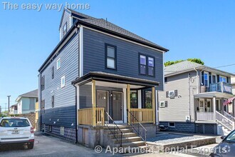
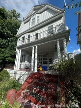
$3,500 / Month
650 Robbins Ave,
Dracut,
MA
01826
Today
Favorites
310-429-4506
-
Bedrooms
3
-
Bathrooms
1.25
-
Square Feet
1,044 sq ft
-
Available
Available Jun 1
Highlights
- Pets Allowed
- Balcony
650 Robbins Ave

Favorites
About This Home
$3,500 deposit,
Available Jun 1
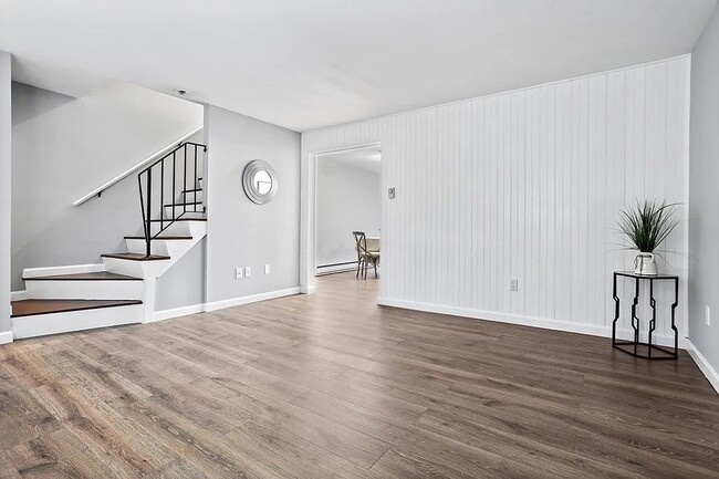
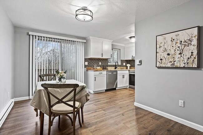
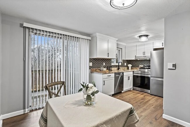
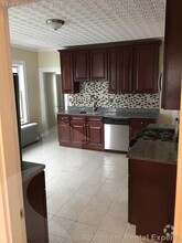
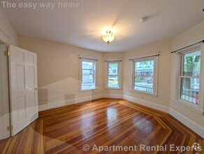
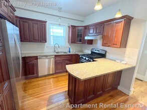
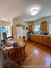
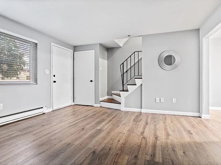
Amazing 3 bedroom, 1.5 bathroom home in Dracut. Basement meets Massachusetts state requirements to be considered a bedroom. However, the space can be whatever you'd like! Amenities included: balcony, deck, dishwasher, stainless steel appliance, updated kitchen, updated bathroom, washer/dryer and keyless entry. Utilities included: water. Is pet friendly. Date Available: Jun 1st 2025. $3,500/month rent. $3,500 security deposit required. Please submit the form on this page to learn more. This property is managed by a responsible landlord using Avail landlord software. Viewings can be scheduled if the rent amount is within your budget and a June move it date is satisfactory.
650 Robbins Ave is a townhome located in Middlesex County and the 01826 ZIP Code. This area is served by the Dracut attendance zone.
* Price shown is base rent and may not include non-optional fees and utilities.
Price, availability, fees, and any applicable rent special are subject to change without notice.
* Square footage definitions vary. Displayed square footage is approximate.
Townhome Features
- Washer/Dryer
- Washer/Dryer Hookup
- Dishwasher
- Balcony
Contact
- Listed by Landlord
- Phone Number (310) 429-4506
- Contact
Location
Get Directions
Amenities
- Washer/Dryer
- Washer/Dryer Hookup
- Dishwasher
- Balcony
Bordering downtown Lowell, the Centralville neighborhood lies about 30 miles north of downtown Boston. The area is primarily residential, with the downtown business district within walking distance across the Merrimack River. Loft-style apartments line the streets near the river, allowing for views of Riverfront Park. The nearby highways of I-93 and I-495 connect the area to Boston, Worcester, and the state of New Hampshire.
Get fresh air by riding your bike along the paths of Merrimack River Bike Path in Centralville, then cross the bridge to Brew'd Awakening Coffeehaus for a cup of coffee and a grilled cheese sandwich. Remember hometown hero Jack Kerouac each year at the Lowell Celebrates Kerouac! festival, where you can join your neighbors on a tour of the city, listen to students read their poetry, or discuss the author's most famous works.
Learn more about living in Centralville
Education
| Colleges & Universities | Distance | ||
|---|---|---|---|
| Colleges & Universities | Distance | ||
| Drive: | 5 min | 1.9 mi | |
| Drive: | 6 min | 2.4 mi | |
| Drive: | 25 min | 12.3 mi | |
| Drive: | 25 min | 13.5 mi |
650 Robbins Ave is within 5 minutes or 1.9 miles from Middlesex C.C., Lowell Campus. It is also near UMass Lowell and Rivier College.
Schools
Public Elementary School
Grades PK-4
480 Students
Nearby
4
Out of 10
Public Elementary School
Grades K-5
240 Students
Attendance Zone
6
Out of 10
Public Middle School
Grades 6-8
848 Students
Attendance Zone
5
Out of 10
Public High School
Grades 9-12
847 Students
Attendance Zone
4
Out of 10
Private Elementary & Middle School
Grades PK-8
234 Students
Nearby
Private Middle & High School
Grades 6-12
19 Students
Nearby
School data provided by
GreatSchools
The GreatSchools Rating helps parents compare schools within a state based on a variety of school quality indicators and provides a helpful picture of how effectively each school serves all of its students. Ratings are on a scale of 1 (below average) to 10 (above average) and can include test scores, college readiness, academic progress, advanced courses, equity, discipline and attendance data. We also advise parents to visit schools, consider other information on school performance and programs, and consider family needs as part of the school selection process.
Transportation options available in Dracut include Alewife Station, located 23.6 miles from 650 Robbins Ave. 650 Robbins Ave is near Manchester Boston Regional, located 29.2 miles or 49 minutes away, and General Edward Lawrence Logan International, located 34.8 miles or 49 minutes away.
| Transit / Subway | Distance | ||
|---|---|---|---|
| Transit / Subway | Distance | ||
|
|
Drive: | 41 min | 23.6 mi |
|
|
Drive: | 39 min | 26.9 mi |
|
|
Drive: | 39 min | 28.3 mi |
| Drive: | 39 min | 28.4 mi | |
|
|
Drive: | 40 min | 29.4 mi |
| Commuter Rail | Distance | ||
|---|---|---|---|
| Commuter Rail | Distance | ||
|
|
Drive: | 8 min | 2.9 mi |
|
|
Drive: | 15 min | 6.4 mi |
|
|
Drive: | 19 min | 10.0 mi |
|
|
Drive: | 22 min | 12.7 mi |
|
|
Drive: | 23 min | 13.6 mi |
| Airports | Distance | ||
|---|---|---|---|
| Airports | Distance | ||
|
Manchester Boston Regional
|
Drive: | 49 min | 29.2 mi |
|
General Edward Lawrence Logan International
|
Drive: | 49 min | 34.8 mi |
Time and distance from 650 Robbins Ave.
| Shopping Centers | Distance | ||
|---|---|---|---|
| Shopping Centers | Distance | ||
| Walk: | 13 min | 0.7 mi | |
| Walk: | 13 min | 0.7 mi | |
| Walk: | 19 min | 1.0 mi |
650 Robbins Ave has 3 shopping centers within 1.0 miles, which is about a 19-minute walk. The miles and minutes will be for the farthest away property.
| Parks and Recreation | Distance | ||
|---|---|---|---|
| Parks and Recreation | Distance | ||
|
Lowell National Historical Park
|
Drive: | 6 min | 2.3 mi |
|
Lowell Heritage State Park
|
Drive: | 9 min | 5.0 mi |
|
Lowell-Dracut-Tyngsboro State Forest
|
Drive: | 12 min | 5.5 mi |
|
Lawrence Heritage State Park
|
Drive: | 18 min | 9.6 mi |
|
The Butterfly Place
|
Drive: | 20 min | 10.5 mi |
650 Robbins Ave has 5 parks within 10.5 miles, including Lowell National Historical Park, Lowell Heritage State Park, and Lowell-Dracut-Tyngsboro State Forest.
| Hospitals | Distance | ||
|---|---|---|---|
| Hospitals | Distance | ||
| Drive: | 7 min | 3.8 mi | |
| Drive: | 17 min | 9.4 mi |
650 Robbins Ave is 3.8 miles from Lowell General Hospital, and is convenient to other hospitals, including Holy Family Hospital.
| Military Bases | Distance | ||
|---|---|---|---|
| Military Bases | Distance | ||
| Drive: | 31 min | 17.2 mi |
650 Robbins Ave is 17.2 miles and a 31 minutes from Hanscom Air Force Base.
You May Also Like
Similar Rentals Nearby
-
-
-
-
 $6,2505 Beds, 1 Bath, 1,855 sq ftTownhome for Rent
 -
-
 $7,9955 Beds, 5.5 Baths, 1,999 sq ftTownhome for Rent
 -
 $4,2003 Beds, 2 Baths, 1,133 sq ftTownhome for Rent
 -
 $5,0004 Beds, 2 Baths, 2,400 sq ftTownhome for Rent
 -
 $3,1003 Beds, 1 Bath, 1,277 sq ftTownhome for Rent
 -
 $4,2003 Beds, 2 Baths, 1,133 sq ftTownhome for Rent

What Are Walk Score®, Transit Score®, and Bike Score® Ratings?
Walk Score® measures the walkability of any address. Transit Score® measures access to public transit. Bike Score® measures the bikeability of any address.
What is a Sound Score Rating?
A Sound Score Rating aggregates noise caused by vehicle traffic, airplane traffic and local sources
650 Robbins Ave
Dracut, MA 01826