656 Saratoga St Unit 205
Boston, MA 02128
-
Bedrooms
2
-
Bathrooms
2
-
Square Feet
--
-
Available
Available Now
Highlight
- Hardwood Floors

About This Home
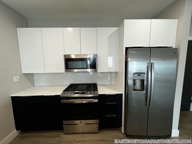
This adorable Apartment 2 beds 2 baths in Boston is available Now. Open kitchen Parking Street, Garage Pet OK Boston Pads is not responsible for any errors, omissions and change in price, prior sale, rent and withdrawal without notice. All information from sources reliable but not guaranteed. Photographs, videos, description and information about the properties reflect conditions at the time the information was obtained. We are pledged to this letter and spirit of U.S. policy for the achievement of equal housing opportunity throughout the Nation. We encourage and support an affirmative advertising and marketing program in which there are no barriers to obtaining housing because of race, color, religion, sex, handicap, familial status, or national origin. ListingID = 4730836
656 Saratoga St is an apartment community located in Suffolk County and the 02128 ZIP Code.
Features
- High Speed Internet Access
- Cable Ready
- Hardwood Floors
Contact
- Phone Number
- Contact
-
Source

- High Speed Internet Access
- Cable Ready
- Hardwood Floors
The historic Harbor View-Orient Heights neighborhood wraps around the Belle Isle Inlet in East Boston. This large neighborhood contains the city's most popular beach, Constitution Beach Park, and is adjacent to the Boston Logan International Airport. With historic architecture lining narrow streets, this neighborhood attracts newcomers with its alluring combination of easy subway commutes and affordable rent prices. There’s an incredible variety of apartments here, including upscale, modern condos to more affordable low-rise apartment communities. From your apartment in Harbor View-Orient Heights, you can reach Downtown Boston in four short stops on the blue line.
Learn more about living in Harbor View-Orient Heights| Colleges & Universities | Distance | ||
|---|---|---|---|
| Colleges & Universities | Distance | ||
| Drive: | 8 min | 3.3 mi | |
| Drive: | 9 min | 3.8 mi | |
| Drive: | 9 min | 4.2 mi | |
| Drive: | 10 min | 4.8 mi |
Transportation options available in Boston include Wood Island Station, located 0.3 mile from 656 Saratoga St Unit 205. 656 Saratoga St Unit 205 is near General Edward Lawrence Logan International, located 1.9 miles or 4 minutes away.
| Transit / Subway | Distance | ||
|---|---|---|---|
| Transit / Subway | Distance | ||
|
|
Walk: | 6 min | 0.3 mi |
|
|
Walk: | 18 min | 0.9 mi |
|
|
Drive: | 3 min | 1.4 mi |
|
|
Drive: | 3 min | 1.5 mi |
|
|
Drive: | 4 min | 2.1 mi |
| Commuter Rail | Distance | ||
|---|---|---|---|
| Commuter Rail | Distance | ||
| Drive: | 6 min | 2.4 mi | |
|
|
Drive: | 7 min | 3.0 mi |
|
|
Drive: | 8 min | 3.8 mi |
|
|
Drive: | 13 min | 4.9 mi |
|
|
Drive: | 12 min | 5.4 mi |
| Airports | Distance | ||
|---|---|---|---|
| Airports | Distance | ||
|
General Edward Lawrence Logan International
|
Drive: | 4 min | 1.9 mi |
Time and distance from 656 Saratoga St Unit 205.
| Shopping Centers | Distance | ||
|---|---|---|---|
| Shopping Centers | Distance | ||
| Drive: | 3 min | 1.2 mi | |
| Drive: | 4 min | 1.9 mi | |
| Drive: | 4 min | 1.9 mi |
| Parks and Recreation | Distance | ||
|---|---|---|---|
| Parks and Recreation | Distance | ||
|
Belle Isle Marsh Reservation
|
Drive: | 4 min | 1.7 mi |
|
Boston National Historical Park
|
Drive: | 8 min | 3.2 mi |
|
New England Aquarium
|
Drive: | 8 min | 3.3 mi |
|
Boston Harbor Islands National Recreation Area
|
Drive: | 7 min | 3.5 mi |
|
Boston Children's Museum
|
Drive: | 7 min | 3.8 mi |
| Hospitals | Distance | ||
|---|---|---|---|
| Hospitals | Distance | ||
| Drive: | 7 min | 3.3 mi | |
| Drive: | 8 min | 3.3 mi | |
| Drive: | 10 min | 4.3 mi |
| Military Bases | Distance | ||
|---|---|---|---|
| Military Bases | Distance | ||
| Drive: | 25 min | 14.4 mi | |
| Drive: | 26 min | 14.9 mi |
656 Saratoga St Unit 205 Photos
Nearby Apartments
Within 50 Miles of 656 Saratoga St Boston, MA 02128
-
345 Harrison
345 Harrison Ave
Boston, MA 02118
2-3 Br $5,380-$8,568 3.4 mi
-
Garrison Square
32-32 Garrison St
Boston, MA 02116
2-3 Br $5,106-$8,245 3.9 mi
-
Baker Chocolate Factory
1200-1220 Adams St
Dorchester, MA 02124
2 Br $3,390-$3,625 8.0 mi
-
Hancock Village
1 Hancock Village Dr
Chestnut Hill, MA 02467
2 Br $3,645-$4,745 8.9 mi
-
Nexxus Apartments
105 Hopkins St
Wakefield, MA 01880
2 Br $2,975-$3,075 9.4 mi
-
Elevation Apartments at Crown Colony
7 Crown Dr
Quincy, MA 02169
2 Br $3,050-$3,330 10.5 mi
What Are Walk Score®, Transit Score®, and Bike Score® Ratings?
Walk Score® measures the walkability of any address. Transit Score® measures access to public transit. Bike Score® measures the bikeability of any address.
What is a Sound Score Rating?
A Sound Score Rating aggregates noise caused by vehicle traffic, airplane traffic and local sources


