$2,200 / Month
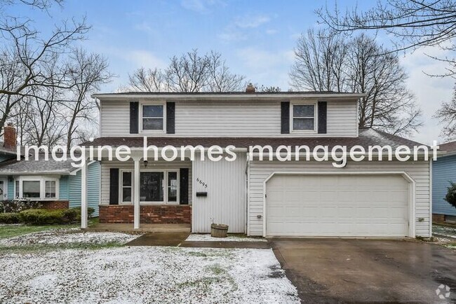
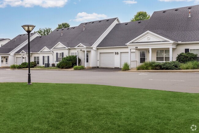
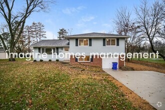
6645 Solon Blvd
Solon, OH 44139
2 Weeks Ago
Favorites
6645 Solon Blvd

Favorites
Check Back Soon for Upcoming Availability
| Beds | Baths | Average SF |
|---|---|---|
| 3 Bedrooms 3 Bedrooms 3 Br | 2 Baths 2 Baths 2 Ba | 1,530 SF |
About This Property
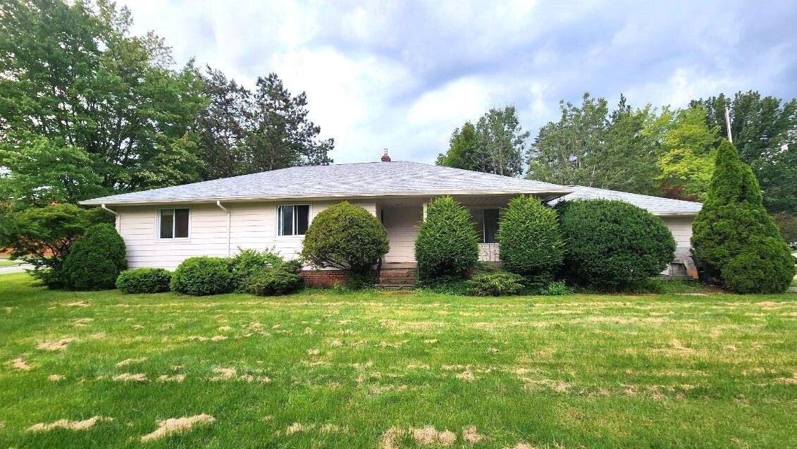
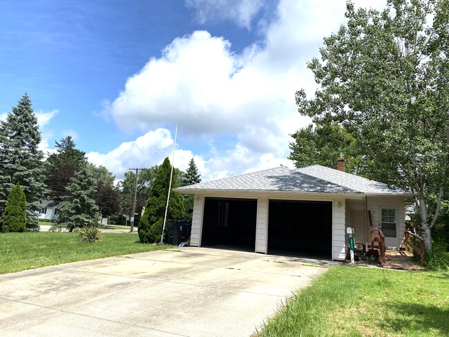
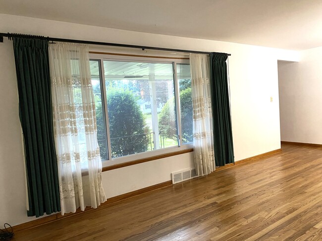
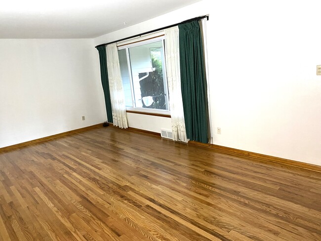
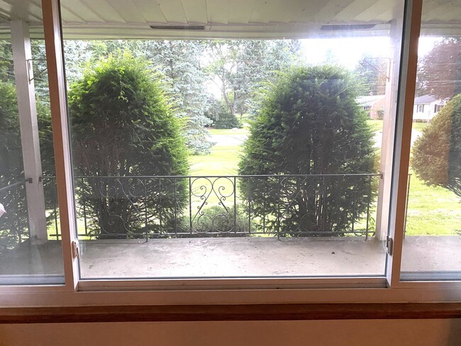
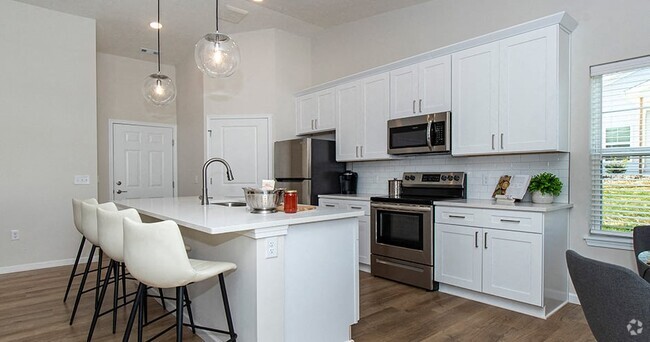
Entirely updated, beautiful three-bedroom ranch house right next to Solon High school. Walking distance to Roxbury Elementary and Orchard Middle schools. Quick and easy access to schools, shopping squares, libraries, Metroparks, public transportation, and highways. Hardwood floor throughout. One Beach-designed Master bedroom with a full bath attached. The other two spacious bedrooms share a walking bathtub. Living room with a large bay window, looking over the private front porch. Cozy, good size family room connected with all previously mentioned rooms. Eat-in kitchen with a large pantry. Spacious 1,000 sqft basement with potential of being a 4th bedroom or an office. Plenty of storage cabinets in the basement. New appliances included. An attached 2 car garage. A shed in the backyard to store equipment. Tenants are responsible for all utilities (gas, electric, water, …) and lawn/snow care. Owner pays for sewer. No smoking. Small pets are considerable with fee and pet deposit. Background and credit check required. No prior evictions. No section 8 or vouchers accepted. Earliest date move-in, August 12!
6645 Solon Blvd is a house located in Cuyahoga County and the 44139 ZIP Code. This area is served by the Solon City attendance zone.
House Features
- Washer/Dryer
- Washer/Dryer Hookup
- Dishwasher
Fees and Policies
The fees below are based on community-supplied data and may exclude additional fees and utilities.
- Dogs Allowed
-
Fees not specified
- Cats Allowed
-
Fees not specified
Location
Get Directions
Southeast Cleveland is a sprawling suburb that encompasses a few cities and neighborhoods. Rentals in the area range from affordable to upscale, so there’s something for every renter. Locals enjoy proximity to Downtown Cleveland, located only 20 miles northwest of town. Southeast Cleveland is home to local restaurants like the Rusty Bucket Restaurant and Tavern, along with chain eateries and abundant shopping options. Country clubs, neighborhood parks, and local college campuses can be found within this region. State Route 43, U.S. Highway 422, and Interstates 480 and 271 making commuting around the Cleveland area simple.
Learn more about living in Southeast Cleveland
Amenities
- Washer/Dryer
- Washer/Dryer Hookup
- Dishwasher
Education
| Colleges & Universities | Distance | ||
|---|---|---|---|
| Colleges & Universities | Distance | ||
| Drive: | 15 min | 6.7 mi | |
| Drive: | 15 min | 8.1 mi | |
| Drive: | 21 min | 9.1 mi | |
| Drive: | 23 min | 11.3 mi |
6645 Solon Blvd is within 15 minutes or 6.7 miles from Cuyahoga C.C., East. It is also near Cuyahoga C.C., Eastern Campus and Ursuline College.
Schools


Public Elementary School
Grades PK-1
736 Students
Nearby
Public Elementary & Middle School
Grades 5-7
736 Students
Attendance Zone
Public Elementary School
Grades K-4
541 Students
Attendance Zone
Public Middle School
Grades 7-8
758 Students
Attendance Zone
Public High School
Grades 9-12
1,483 Students
Attendance Zone
Private Elementary & Middle School
Grades PK-8
376 Students
Nearby
Private High School
Grades 9-12
306 Students
Nearby
School data provided by
 The GreatSchools Rating helps parents compare schools within a state based on a variety of school quality indicators and provides a helpful picture of how effectively each school serves all of its students. Ratings are on a scale of 1 (below average) to 10 (above average) and can include test scores, college readiness, academic progress, advanced courses, equity, discipline and attendance data. We also advise parents to visit schools, consider other information on school performance and programs, and consider family needs as part of the school selection process.
View GreatSchools Rating Methodology
View GreatSchools Rating Methodology
Transportation options available in Solon include Warrensville (Blue Line), located 9.0 miles from 6645 Solon Blvd. 6645 Solon Blvd is near Cleveland-Hopkins International, located 24.0 miles or 39 minutes away, and Akron-Canton Regional, located 37.1 miles or 56 minutes away.
| Transit / Subway | Distance | ||
|---|---|---|---|
| Transit / Subway | Distance | ||
|
|
Drive: | 17 min | 9.0 mi |
|
|
Drive: | 18 min | 9.5 mi |
|
|
Drive: | 19 min | 9.9 mi |
|
|
Drive: | 20 min | 10.6 mi |
|
|
Drive: | 21 min | 10.7 mi |
| Commuter Rail | Distance | ||
|---|---|---|---|
| Commuter Rail | Distance | ||
| Drive: | 25 min | 11.3 mi | |
| Drive: | 25 min | 11.7 mi | |
| Drive: | 30 min | 13.2 mi | |
| Drive: | 30 min | 15.8 mi | |
| Drive: | 31 min | 16.0 mi |
| Airports | Distance | ||
|---|---|---|---|
| Airports | Distance | ||
|
Cleveland-Hopkins International
|
Drive: | 39 min | 24.0 mi |
|
Akron-Canton Regional
|
Drive: | 56 min | 37.1 mi |
Time and distance from 6645 Solon Blvd.
| Shopping Centers | Distance | ||
|---|---|---|---|
| Shopping Centers | Distance | ||
| Walk: | 12 min | 0.6 mi | |
| Walk: | 12 min | 0.7 mi | |
| Walk: | 14 min | 0.8 mi |
6645 Solon Blvd has 3 shopping centers within 0.8 mile, which is about a 14-minute walk. The miles and minutes will be for the farthest away property.
| Parks and Recreation | Distance | ||
|---|---|---|---|
| Parks and Recreation | Distance | ||
|
South Chagrin Reservation
|
Drive: | 10 min | 3.9 mi |
|
Frohring Meadows
|
Drive: | 19 min | 7.3 mi |
|
Liberty Park and Nature Center
|
Drive: | 14 min | 7.5 mi |
|
Bedford Reservation
|
Drive: | 21 min | 8.8 mi |
|
Tinkers Creek State Park
|
Drive: | 19 min | 9.5 mi |
6645 Solon Blvd has 5 parks within 9.5 miles, including South Chagrin Reservation, Frohring Meadows, and Liberty Park and Nature Center.
| Hospitals | Distance | ||
|---|---|---|---|
| Hospitals | Distance | ||
| Drive: | 14 min | 7.3 mi | |
| Drive: | 16 min | 7.9 mi | |
| Drive: | 16 min | 8.4 mi |
6645 Solon Blvd has 3 hospitals within 8.4 miles, the nearest is University Hospitals Ahuja Medical Center which is 7.3 miles away and a 14 minute drive.
| Military Bases | Distance | ||
|---|---|---|---|
| Military Bases | Distance | ||
| Drive: | 102 min | 83.6 mi |
6645 Solon Blvd is 83.6 miles and a 102 minute drive from Mansfield Lahm Airport Air Guard Station.
You May Also Like
Similar Rentals Nearby
What Are Walk Score®, Transit Score®, and Bike Score® Ratings?
Walk Score® measures the walkability of any address. Transit Score® measures access to public transit. Bike Score® measures the bikeability of any address.
What is a Sound Score Rating?
A Sound Score Rating aggregates noise caused by vehicle traffic, airplane traffic and local sources

6645 Solon Blvd
Solon, OH 44139