

$2,775 / Month
67 Cedar St Unit 2
Somerville, MA 02143
2 Weeks Ago
Favorites
67 Cedar St Unit 2

Favorites
Check Back Soon for Upcoming Availability
| Beds | Baths | Average SF |
|---|---|---|
| 3 Bedrooms 3 Bedrooms 3 Br | 1 Bath 1 Bath 1 Ba | 1,000 SF |
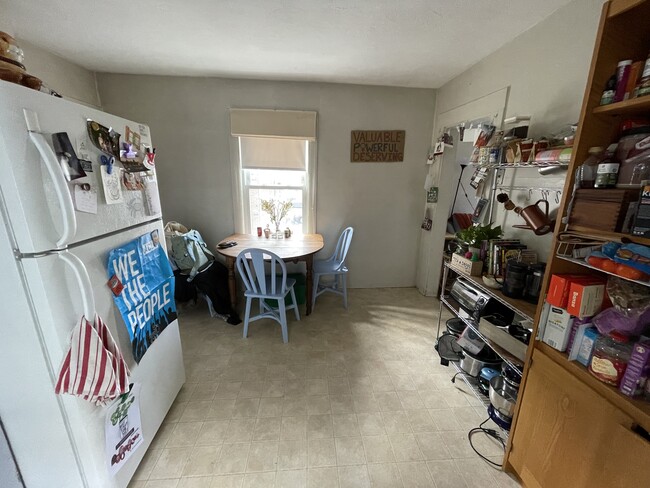
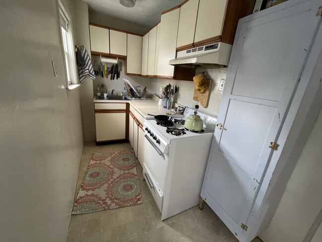
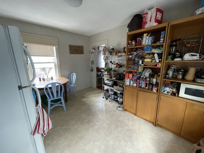
About This Property
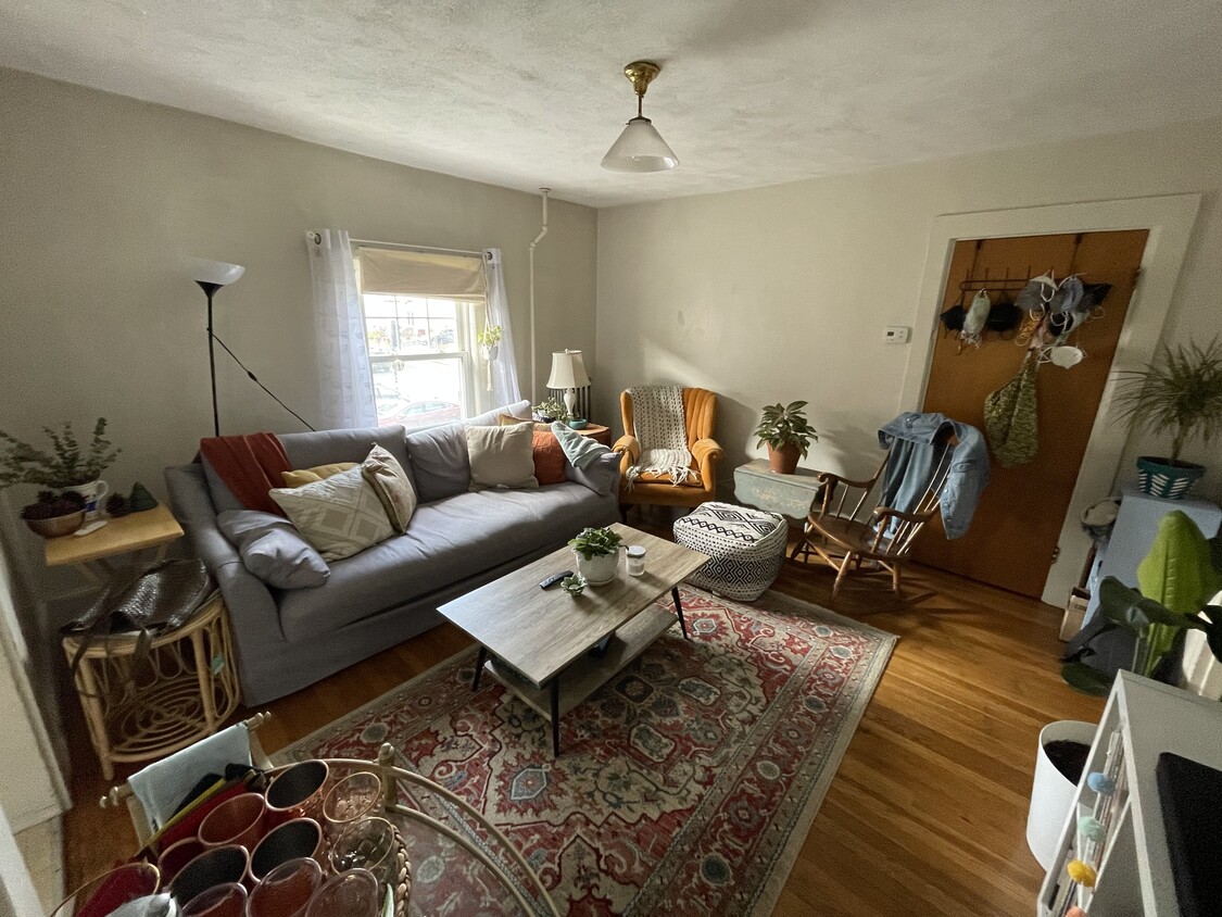
Large 2nd floor 3-bed/1-bath apartment over two floors, for rent in Somerville. Short 6-minute walk to Davis Square, red line, grocery stores, shops, restaurants and cafes. Eat-in kitchen with gas stove and fridge. Living room with hardwood floors throughout. All three bedrooms can comfortably fit queen beds. Coin-op laundry in-basement. Parking by permit. Cats OK. Available 9/1. First, security and brokers
67 Cedar St is an apartment community located in Middlesex County and the 02143 ZIP Code.
Apartment Features
Hardwood Floors
Smoke Free
Basement
Eat-in Kitchen
- Smoke Free
- Eat-in Kitchen
- Kitchen
- Hardwood Floors
- Basement
Fees and Policies
The fees below are based on community-supplied data and may exclude additional fees and utilities.
- Cats Allowed
-
Fees not specified
-
Weight limit--
-
Pet Limit--
Details
Utilities Included
-
Water
-
Sewer
Property Information
-
2 units
Location
Get Directions
Powder House Square neighborhood sits within Somerville a few miles north of Cambridge and Boston. The community derives its name from an 18th century windmill that was later transformed into a gunpowder storage depot that played a major role in the American Revolution. This urban community features apartments in New England style multi-family units. Just a few walkable blocks from the neighborhood's northern border sits Tufts University's primary campus. The neighborhood is also defined by its traffic circle, which contains an island park with benches, pathways, and landscaped shrubbery. While it is largely a residential area, it is home to a number of restaurants and several medical and dental clinics.
Many students and neighborhood residents visit Nathan Tufts Park, where the iconic Powder House is located. Here you can walk your dog or have a picnic under the shade cast by trees hundreds of years old.
Learn more about living in Powder House SquareBelow are rent ranges for similar nearby apartments
| Beds | Average Size | Lowest | Typical | Premium |
|---|---|---|---|---|
| Studio Studio Studio | 2297-2298 Sq Ft | $1,900 | $2,274 | $3,585 |
| 1 Bed 1 Bed 1 Bed | 4070-4072 Sq Ft | $1,540 | $2,614 | $4,175 |
| 2 Beds 2 Beds 2 Beds | 4396 Sq Ft | $2,275 | $3,373 | $5,200 |
| 3 Beds 3 Beds 3 Beds | 5908 Sq Ft | $420 | $4,008 | $6,000 |
| 4 Beds 4 Beds 4 Beds | 5808 Sq Ft | $975 | $5,441 | $12,000 |
Amenities
- Smoke Free
- Eat-in Kitchen
- Kitchen
- Hardwood Floors
- Basement
Expenses
Utilities Included
Water, Sewer
Included
Education
| Colleges & Universities | Distance | ||
|---|---|---|---|
| Colleges & Universities | Distance | ||
| Walk: | 9 min | 0.5 mi | |
| Walk: | 19 min | 1.0 mi | |
| Drive: | 4 min | 1.6 mi | |
| Drive: | 4 min | 1.7 mi |
67 Cedar St Unit 2 is within 9 minutes or 0.5 mile from Lesley University, Porter. It is also near Lesley University and Tufts Univ., Medford.
Transportation options available in Somerville include Porter Square Station, located 0.5 mile from 67 Cedar St Unit 2. 67 Cedar St Unit 2 is near General Edward Lawrence Logan International, located 6.7 miles or 15 minutes away.
| Transit / Subway | Distance | ||
|---|---|---|---|
| Transit / Subway | Distance | ||
|
|
Walk: | 9 min | 0.5 mi |
| Walk: | 12 min | 0.6 mi | |
|
|
Walk: | 14 min | 0.7 mi |
| Drive: | 3 min | 1.1 mi | |
| Drive: | 4 min | 1.5 mi |
| Commuter Rail | Distance | ||
|---|---|---|---|
| Commuter Rail | Distance | ||
|
|
Walk: | 9 min | 0.5 mi |
|
|
Drive: | 7 min | 3.1 mi |
|
|
Drive: | 10 min | 3.7 mi |
|
|
Drive: | 9 min | 4.4 mi |
| Drive: | 17 min | 8.1 mi |
| Airports | Distance | ||
|---|---|---|---|
| Airports | Distance | ||
|
General Edward Lawrence Logan International
|
Drive: | 15 min | 6.7 mi |
Time and distance from 67 Cedar St Unit 2.
| Shopping Centers | Distance | ||
|---|---|---|---|
| Shopping Centers | Distance | ||
| Walk: | 7 min | 0.4 mi | |
| Walk: | 8 min | 0.4 mi | |
| Walk: | 8 min | 0.5 mi |
67 Cedar St Unit 2 has 3 shopping centers within 0.5 mile, which is about a 8-minute walk. The miles and minutes will be for the farthest away property.
| Parks and Recreation | Distance | ||
|---|---|---|---|
| Parks and Recreation | Distance | ||
|
Harvard Museum of Natural History
|
Walk: | 19 min | 1.0 mi |
|
Mineralogical and Geological Museum
|
Walk: | 19 min | 1.0 mi |
|
Harvard-Smithsonian Center for Astrophysics
|
Drive: | 5 min | 1.3 mi |
|
Longfellow National Historic Site
|
Drive: | 4 min | 1.7 mi |
|
Mystic River Reservation
|
Drive: | 6 min | 2.8 mi |
67 Cedar St Unit 2 has 5 parks within 2.8 miles, including Mineralogical and Geological Museum, Harvard Museum of Natural History, and Harvard-Smithsonian Center for Astrophysics.
| Hospitals | Distance | ||
|---|---|---|---|
| Hospitals | Distance | ||
| Drive: | 5 min | 1.7 mi | |
| Drive: | 6 min | 2.3 mi | |
| Drive: | 9 min | 3.7 mi |
67 Cedar St Unit 2 has 3 hospitals within 3.7 miles, the nearest is Cambridge Health Alliance which is 1.7 miles away and a 5 minute drive.
| Military Bases | Distance | ||
|---|---|---|---|
| Military Bases | Distance | ||
| Drive: | 22 min | 11.2 mi | |
| Drive: | 33 min | 18.2 mi |
67 Cedar St Unit 2 is 11.2 miles from Hanscom Air Force Base, and is convenient to other military bases, including US Military Reservation.
You May Also Like
Similar Rentals Nearby


What Are Walk Score®, Transit Score®, and Bike Score® Ratings?
Walk Score® measures the walkability of any address. Transit Score® measures access to public transit. Bike Score® measures the bikeability of any address.
What is a Sound Score Rating?
A Sound Score Rating aggregates noise caused by vehicle traffic, airplane traffic and local sources
67 Cedar St
Somerville, MA 02143