
$3,500 / Month
67 Maple St
Needham, MA 02492
Today
Favorites
617-663-8648
-
Bedrooms
2
-
Bathrooms
1
-
Square Feet
1,200 sq ft
-
Available
Available Now
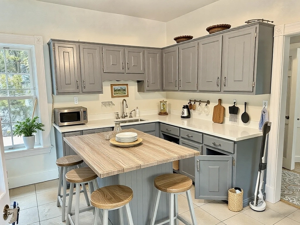
67 Maple St Unit 67

Favorites
About This Home
$3,500 deposit,
Available Now
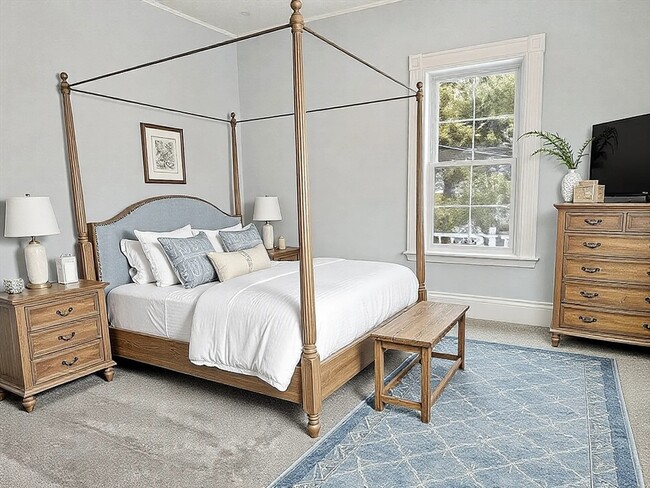
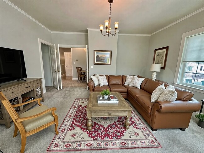
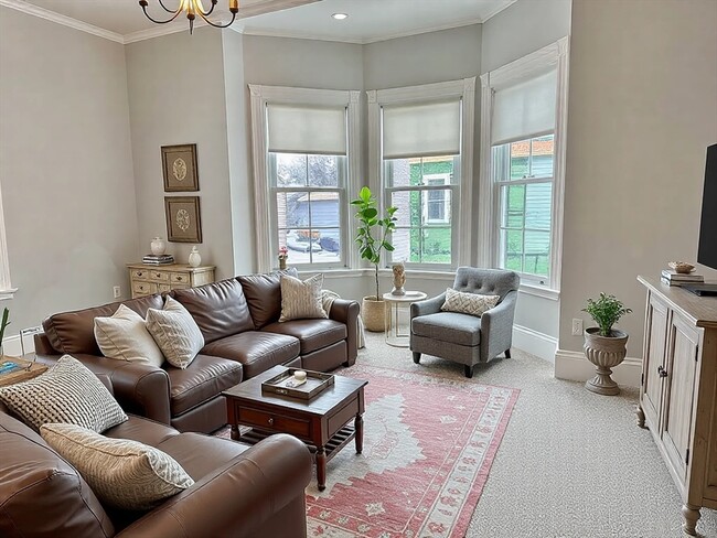
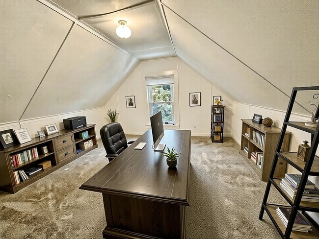
Spacious 2-Bedroom Apartment with Home Office – 67 Maple Street,NeedhamLarge 7-room unit in a historic Needham farmhouse,offering a flexible layout with three bedrooms plus a dedicated home office. This freshly updated apartment spans two floors,providing ample space for work,relaxation,and entertaining.Features:Two spacious bedrooms plus a home officeFreshly painted with all-new carpeted floorsTwo off-street parking spacesShared laundry in the basementShort walk to Needham Center,shops,restaurants,and the commuter railAvailable: Move-in ready by March 1 (or sooner if needed)Pets: Considered on a case-by-case basis with potential for additional rentContact us today to schedule a showing!
67 Maple St is an apartment community located in Norfolk County and the 02492 ZIP Code.
* Price shown is base rent and may not include non-optional fees and utilities.
Price, availability, fees, and any applicable rent special are subject to change without notice.
* Square footage definitions vary. Displayed square footage is approximate.
Features
Dishwasher
Refrigerator
Disposal
Freezer
- Dishwasher
- Disposal
- Refrigerator
- Freezer
Contact
- Listed by Andrew Goldberg
- Phone Number (617) 663-8648
-
Source
 MLS Property Information Network
The property listing data and information set forth herein were provided to MLS Property Information Network, Inc. from third party sources, including sellers, lessors and public records, and were compiled by MLS Property Information Network, Inc. The property listing data and information are for the personal, non-commercial use of consumers having a good faith interest in purchasing or leasing listed properties of the type displayed to them and may not be used for any purpose other than to identify prospective properties which such consumers may have a good faith interest in purchasing or leasing. MLS Property Information Network, Inc. and its subscribers disclaim any and all representations and warranties as to the accuracy of the property listing data and information set forth herein. All properties are subject to prior sale, change or withdrawal. Copyright © 2025 MLS Property Information Network, Inc. All rights reserved.
Location
Get Directions
Amenities
- Dishwasher
- Disposal
- Refrigerator
- Freezer
Just west of Boston and East of Worcester sits Metro West, a region that houses a group of towns and cities with significant historical backgrounds. A total of 19 municipalities make up the core of this community, but other municipalities are considered to be a part of the Interstate 495/Metro West Corridor.
Learn more about living in Metro West
Education
| Colleges & Universities | Distance | ||
|---|---|---|---|
| Colleges & Universities | Distance | ||
| Drive: | 5 min | 2.2 mi | |
| Drive: | 10 min | 4.5 mi | |
| Drive: | 13 min | 6.8 mi | |
| Drive: | 14 min | 7.2 mi |
67 Maple St Unit 67 is within 5 minutes or 2.2 miles from Babson College. It is also near Wellesley College and Boston College.
Transportation options available in Needham include Newton Highlands Station, located 3.8 miles from 67 Maple St Unit 67. 67 Maple St Unit 67 is near General Edward Lawrence Logan International, located 17.0 miles or 31 minutes away, and Worcester Regional, located 35.5 miles or 61 minutes away.
| Transit / Subway | Distance | ||
|---|---|---|---|
| Transit / Subway | Distance | ||
|
|
Drive: | 7 min | 3.8 mi |
|
|
Drive: | 9 min | 4.1 mi |
|
|
Drive: | 9 min | 4.3 mi |
|
|
Drive: | 10 min | 5.5 mi |
|
|
Drive: | 11 min | 5.7 mi |
| Commuter Rail | Distance | ||
|---|---|---|---|
| Commuter Rail | Distance | ||
|
|
Walk: | 5 min | 0.3 mi |
|
|
Walk: | 10 min | 0.5 mi |
|
|
Drive: | 3 min | 1.2 mi |
|
|
Drive: | 4 min | 1.7 mi |
|
|
Drive: | 7 min | 3.7 mi |
| Airports | Distance | ||
|---|---|---|---|
| Airports | Distance | ||
|
General Edward Lawrence Logan International
|
Drive: | 31 min | 17.0 mi |
|
Worcester Regional
|
Drive: | 61 min | 35.5 mi |
Time and distance from 67 Maple St Unit 67.
| Shopping Centers | Distance | ||
|---|---|---|---|
| Shopping Centers | Distance | ||
| Walk: | 5 min | 0.3 mi | |
| Drive: | 4 min | 2.3 mi | |
| Drive: | 5 min | 2.5 mi |
67 Maple St Unit 67 has 3 shopping centers within 2.5 miles, which is about a 5-minute drive. The miles and minutes will be for the farthest away property.
| Parks and Recreation | Distance | ||
|---|---|---|---|
| Parks and Recreation | Distance | ||
|
Cutler Park Reservation
|
Drive: | 6 min | 2.7 mi |
|
Hemlock Gorge Reservation
|
Drive: | 6 min | 3.0 mi |
|
Horticultural Society at Elm Bank
|
Drive: | 11 min | 4.3 mi |
|
Weezie's Garden for Children
|
Drive: | 13 min | 5.8 mi |
|
Elm Bank Reservation
|
Drive: | 13 min | 5.8 mi |
67 Maple St Unit 67 has 5 parks within 5.8 miles, including Cutler Park Reservation, Hemlock Gorge Reservation, and Horticultural Society at Elm Bank.
| Hospitals | Distance | ||
|---|---|---|---|
| Hospitals | Distance | ||
| Walk: | 4 min | 0.2 mi | |
| Drive: | 9 min | 5.2 mi | |
| Drive: | 11 min | 5.7 mi |
67 Maple St Unit 67 has 3 hospitals within 5.7 miles, the nearest is Beth Israel Deaconess Hospital - Needham which is 0.2 mile away and a 4 minutes drive.
| Military Bases | Distance | ||
|---|---|---|---|
| Military Bases | Distance | ||
| Drive: | 14 min | 7.2 mi | |
| Drive: | 26 min | 15.2 mi |
67 Maple St Unit 67 is 7.2 miles from US Military Reservation, and is convenient to other military bases, including Hanscom Air Force Base.
You May Also Like
Similar Rentals Nearby


What Are Walk Score®, Transit Score®, and Bike Score® Ratings?
Walk Score® measures the walkability of any address. Transit Score® measures access to public transit. Bike Score® measures the bikeability of any address.
What is a Sound Score Rating?
A Sound Score Rating aggregates noise caused by vehicle traffic, airplane traffic and local sources
67 Maple St
Needham, MA 02492