
$5,000 / Month
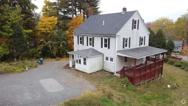
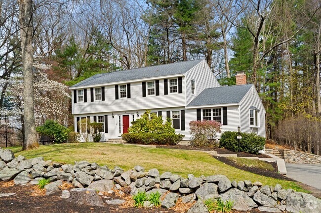
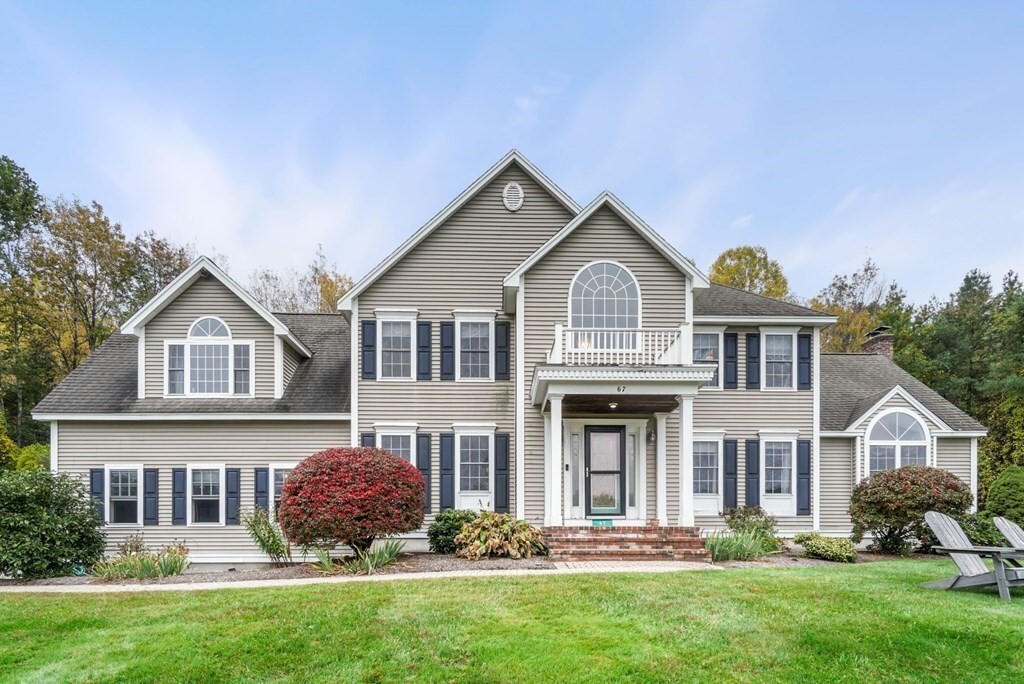
67 Sky Top Ln
Dunstable, MA 01827
2 Weeks Ago
Favorites
67 Sky Top Ln

Favorites
Check Back Soon for Upcoming Availability
| Beds | Baths | Average SF |
|---|---|---|
| 4 Bedrooms 4 Bedrooms 4 Br | 2.5 Baths 2.5 Baths 2.5 Ba | 4,500 SF |
About This Property
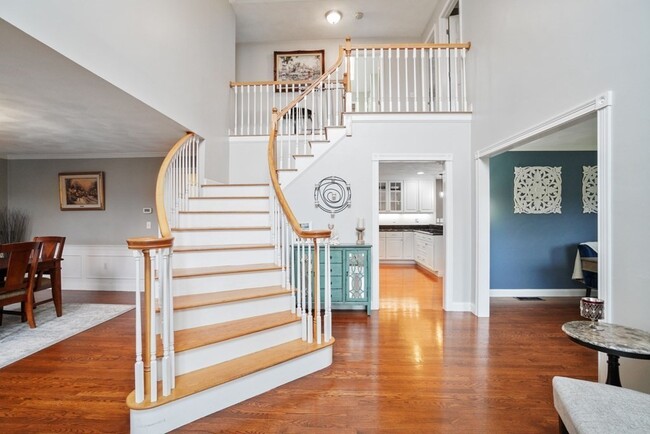
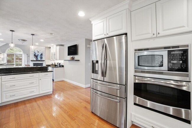
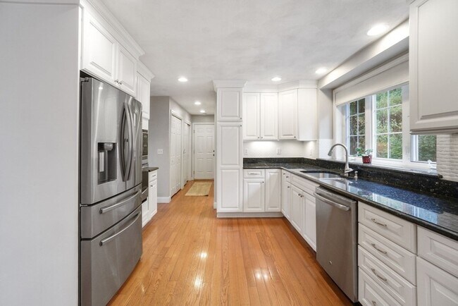
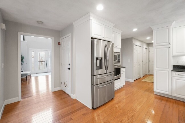
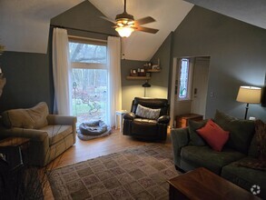
FULLY FURNISHED rental! 4 bed 3 bath Colonial home. This property sits high on 2.5 acres abutting hundreds of acres of conservation land and trails at the end of a cul- de sac in the sought after meadow view hills neighborhood. Plenty of room here as the 1st floor offers a large eat in kitchen with granite counters,stainless steel appliances,peninsula and wet bar which leads to a front to back family room with cathedral ceilings and pellet fireplace. A formal wianscott dining room,traditional living room / office,1/2 bath and laundry complete this level. Upstairs includes 3 large bedrooms a full bath and a massive primary bedroom with vaulted ceilings,sky lights and spa inspired en suite bath with double vanity,glass shower and jacuzzi tub. The finished basement offers tons of extra space and is perfect for entertaining and includes a wood burning fireplace,full size windows for natural light and separate rooms for additional storage. Move in ready with furnishings included!
67 Sky Top Ln is a house located in Middlesex County and the 01827 ZIP Code. This area is served by the Nashua attendance zone.
Fees and Policies
The fees below are based on community-supplied data and may exclude additional fees and utilities.
- Dogs Allowed
-
Fees not specified
- Cats Allowed
-
Fees not specified
Location
Get Directions
Situated just south of the New Hampshire border, Dunstable is a picturesque town brimming with rural charm and a strong sense of community. Dunstable is largely residential, boasting an array of houses and nearby apartments available for rent in a park-like locale.
Dunstable exudes an overall peaceful atmosphere, which is defined by its rolling fields, lush forests, and vast conservation areas. In addition to its pervasive natural beauty, Dunstable offers residents access to a slew of local businesses strewn along State Highway 113. The town is also convenient to Pheasant Lane Mall in neighboring Nashua, New Hampshire. Nearby U.S. Route 3 connects Dunstable to Nashua, Lowell, and beyond.
Learn more about living in DunstableBelow are rent ranges for similar nearby apartments
Education
| Colleges & Universities | Distance | ||
|---|---|---|---|
| Colleges & Universities | Distance | ||
| Drive: | 16 min | 7.5 mi | |
| Drive: | 28 min | 12.7 mi | |
| Drive: | 31 min | 13.8 mi | |
| Drive: | 45 min | 22.0 mi |
67 Sky Top Ln is within 16 minutes or 7.5 miles from Rivier College. It is also near UMass Lowell and Middlesex C.C., Lowell Campus.
Schools


Charter Elementary & Middle School
Grades K-8
297 Students
Nearby
Public Elementary School
Grades PK-5
541 Students
Nearby
Public Elementary School
Grades K-5
416 Students
Nearby
Public Middle School
Grades 6-8
561 Students
Nearby
Public High School
Grades 9-12
680 Students
Attendance Zone
Private Elementary, Middle & High School
Grades PK-12
127 Students
Nearby
Private High School
Grades 9-12
793 Students
Nearby
School data provided by
 The GreatSchools Rating helps parents compare schools within a state based on a variety of school quality indicators and provides a helpful picture of how effectively each school serves all of its students. Ratings are on a scale of 1 (below average) to 10 (above average) and can include test scores, college readiness, academic progress, advanced courses, equity, discipline and attendance data. We also advise parents to visit schools, consider other information on school performance and programs, and consider family needs as part of the school selection process.
View GreatSchools Rating Methodology
View GreatSchools Rating Methodology
Transportation options available in Dunstable include Alewife Station, located 32.0 miles from 67 Sky Top Ln. 67 Sky Top Ln is near Manchester Boston Regional, located 19.8 miles or 34 minutes away, and General Edward Lawrence Logan International, located 46.7 miles or 71 minutes away.
| Transit / Subway | Distance | ||
|---|---|---|---|
| Transit / Subway | Distance | ||
|
|
Drive: | 57 min | 32.0 mi |
|
|
Drive: | 59 min | 32.3 mi |
| Drive: | 58 min | 32.4 mi | |
|
|
Drive: | 60 min | 35.9 mi |
|
|
Drive: | 61 min | 38.8 mi |
| Commuter Rail | Distance | ||
|---|---|---|---|
| Commuter Rail | Distance | ||
|
|
Drive: | 30 min | 13.6 mi |
|
|
Drive: | 33 min | 16.2 mi |
|
|
Drive: | 37 min | 17.2 mi |
|
|
Drive: | 34 min | 17.4 mi |
|
|
Drive: | 38 min | 18.9 mi |
| Airports | Distance | ||
|---|---|---|---|
| Airports | Distance | ||
|
Manchester Boston Regional
|
Drive: | 34 min | 19.8 mi |
|
General Edward Lawrence Logan International
|
Drive: | 71 min | 46.7 mi |
Time and distance from 67 Sky Top Ln.
| Shopping Centers | Distance | ||
|---|---|---|---|
| Shopping Centers | Distance | ||
| Drive: | 13 min | 4.2 mi | |
| Drive: | 15 min | 4.8 mi | |
| Drive: | 15 min | 4.9 mi |
67 Sky Top Ln has 3 shopping centers within 4.9 miles, which is about a 15-minute drive. The miles and minutes will be for the farthest away property.
| Parks and Recreation | Distance | ||
|---|---|---|---|
| Parks and Recreation | Distance | ||
|
Mine Falls Park
|
Drive: | 13 min | 5.5 mi |
|
Nashua National Fish Hatchery
|
Drive: | 14 min | 6.4 mi |
|
The Butterfly Place
|
Drive: | 18 min | 6.5 mi |
|
Beaver Brook Association
|
Drive: | 19 min | 6.9 mi |
|
Nashua River Rail Trail
|
Drive: | 22 min | 9.1 mi |
67 Sky Top Ln has 5 parks within 9.1 miles, including Mine Falls Park, Nashua National Fish Hatchery, and The Butterfly Place.
| Hospitals | Distance | ||
|---|---|---|---|
| Hospitals | Distance | ||
| Drive: | 12 min | 5.2 mi | |
| Drive: | 15 min | 6.3 mi | |
| Drive: | 31 min | 14.6 mi |
67 Sky Top Ln has 3 hospitals within 14.6 miles, the nearest is St. Joseph Hospital which is 5.2 miles away and a 12 minute drive.
You May Also Like
Similar Rentals Nearby


What Are Walk Score®, Transit Score®, and Bike Score® Ratings?
Walk Score® measures the walkability of any address. Transit Score® measures access to public transit. Bike Score® measures the bikeability of any address.
What is a Sound Score Rating?
A Sound Score Rating aggregates noise caused by vehicle traffic, airplane traffic and local sources
67 Sky Top Ln
Dunstable, MA 01827