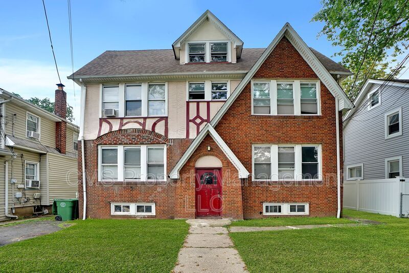
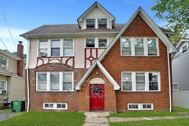
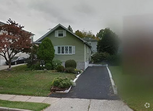
706 Chestnut St
Roselle, NJ 07203
Favorites

706 Chestnut St
Favorites
Check Back Soon for Upcoming Availability
| Beds | Baths | Average SF |
|---|---|---|
| 1 Bedroom 1 Bedroom 1 Br | 1 Bath 1 Bath 1 Ba | — |
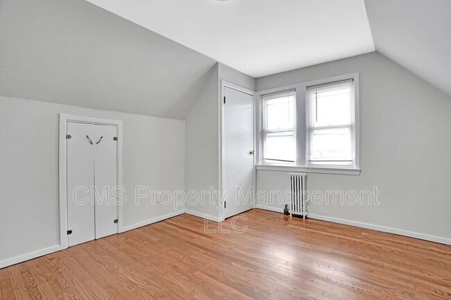
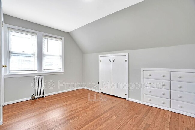
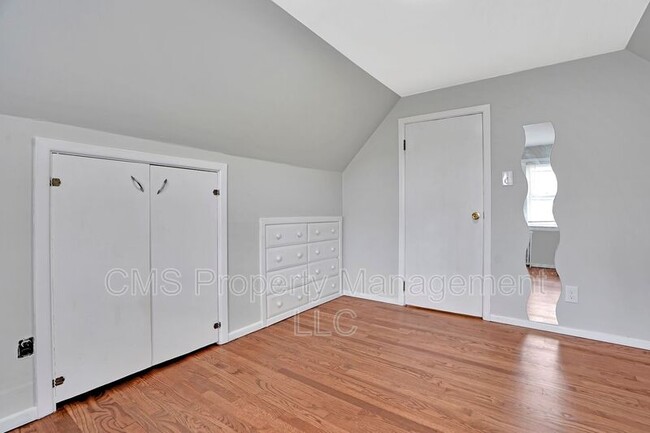
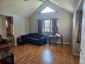
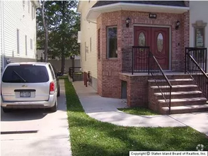
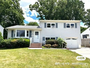
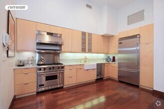
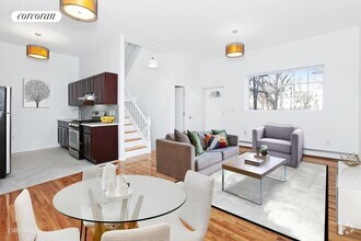
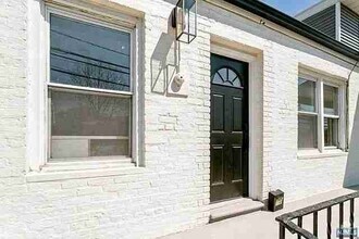
About This Property
Introducing this beautiful 1-bedroom, 1-bathroom unit that is now rent ready and just waiting for its new tenant! The home boasts a very clean look. Located near schools and malls, you can never go wrong in renting this gorgeous house. Please be aware that the tenant is responsible for paying all utilities. A security deposit equal to 1.5 times the rent, the real estate commission of 1 month's rent, and the first month's rent is due upon signing the lease.
706 Chestnut St is a house located in Union County and the 07203 ZIP Code. This area is served by the Roselle Public attendance zone.
Property Address:
706 Chestnut St,
Roselle,
NJ
07203
 This Property
 Available Property
Ideally located about 10 miles southwest of Newark and 18 miles from New York City, Roselle is a cozy borough for those looking for a quieter place to call home. First settled around 1664, Roselle was settled by farmers looking for better farmland. It was part of the first New Jersey settlement called Elizabethtown. The borough was officially incorporated in 1894 as Roselle.
Today, this terrific community features beautiful parks and great shopping. Warinanco Park, the borough's largest park, offers ball fields, a running track, a playground, pedal boats, an ice skating rink, a fitness trail, a bicycle path, fishing, a spray pool, tennis courts, picnic areas, and shuffleboard. Roselle's tree-lined streets are mainly residential, with a shopping district located between Westfield Avenue and West 1st Avenue.
Learn more about living in Roselle
Education
| Colleges & Universities | Distance | ||
|---|---|---|---|
| Colleges & Universities | Distance | ||
| Drive: | 7 min | 2.9 mi | |
| Drive: | 9 min | 3.5 mi | |
| Drive: | 12 min | 4.2 mi | |
| Drive: | 19 min | 10.4 mi |
706 Chestnut St is within 7 minutes or 2.9 miles from Union County Coll., Elizabeth. It is also near Kean University and Union County College, Cranford.
Schools
Public Elementary School
Grades K
200 Students
Attendance Zone
Public Elementary School
Grades PK & 1-4
301 Students
Attendance Zone
3
Out of 10
Public Elementary School
Grades 5-6
436 Students
Attendance Zone
3
Out of 10
Public Elementary School
Grades PK-5
290 Students
Nearby
6
Out of 10
Public Middle School
Grades 7-8
435 Students
Attendance Zone
5
Out of 10
Public High School
Grades 9-12
884 Students
Attendance Zone
1
Out of 10
Private Elementary & Middle School
Grades PK-8
199 Students
Nearby
Private High School
Grades 9-12
354 Students
Nearby
School data provided by
GreatSchools
The GreatSchools Rating helps parents compare schools within a state based on a variety of school quality indicators and provides a helpful picture of how effectively each school serves all of its students. Ratings are on a scale of 1 (below average) to 10 (above average) and can include test scores, college readiness, academic progress, advanced courses, equity, discipline and attendance data. We also advise parents to visit schools, consider other information on school performance and programs, and consider family needs as part of the school selection process.
Transportation options available in Roselle include Military Park, located 9.3 miles from 706 Chestnut St. 706 Chestnut St is near Newark Liberty International, located 12.4 miles or 18 minutes away, and Laguardia, located 27.6 miles or 52 minutes away.
| Transit / Subway | Distance | ||
|---|---|---|---|
| Transit / Subway | Distance | ||
|
|
Drive: | 17 min | 9.3 mi |
|
|
Drive: | 17 min | 9.8 mi |
|
|
Drive: | 18 min | 10.7 mi |
| Drive: | 19 min | 11.1 mi | |
|
|
Drive: | 18 min | 11.2 mi |
| Commuter Rail | Distance | ||
|---|---|---|---|
| Commuter Rail | Distance | ||
|
|
Drive: | 4 min | 1.5 mi |
|
|
Drive: | 4 min | 2.0 mi |
|
|
Drive: | 7 min | 2.9 mi |
|
|
Drive: | 7 min | 3.1 mi |
|
|
Drive: | 8 min | 3.8 mi |
| Airports | Distance | ||
|---|---|---|---|
| Airports | Distance | ||
|
Newark Liberty International
|
Drive: | 18 min | 12.4 mi |
|
Laguardia
|
Drive: | 52 min | 27.6 mi |
Time and distance from 706 Chestnut St.
| Shopping Centers | Distance | ||
|---|---|---|---|
| Shopping Centers | Distance | ||
| Walk: | 18 min | 1.0 mi | |
| Drive: | 3 min | 1.3 mi | |
| Drive: | 3 min | 1.5 mi |
706 Chestnut St has 3 shopping centers within 1.5 miles, which is about a 3-minute drive. The miles and minutes will be for the farthest away property.
| Parks and Recreation | Distance | ||
|---|---|---|---|
| Parks and Recreation | Distance | ||
|
William Miller Sperry Observatory
|
Drive: | 10 min | 4.1 mi |
|
Hawk Rise Sanctuary
|
Drive: | 11 min | 4.4 mi |
|
Merrill Park
|
Drive: | 14 min | 6.1 mi |
|
Liberty State Park
|
Drive: | 15 min | 7.2 mi |
|
Staten Island Industrial Park
|
Drive: | 15 min | 8.6 mi |
706 Chestnut St has 5 parks within 8.6 miles, including William Miller Sperry Observatory, Hawk Rise Sanctuary, and Merrill Park.
| Hospitals | Distance | ||
|---|---|---|---|
| Hospitals | Distance | ||
| Drive: | 8 min | 3.3 mi | |
| Drive: | 8 min | 3.6 mi | |
| Drive: | 13 min | 7.8 mi |
706 Chestnut St has 3 hospitals within 7.8 miles, the nearest is Trinitas Regional Medical Center which is 3.3 miles away and a 8 minutes drive.
| Military Bases | Distance | ||
|---|---|---|---|
| Military Bases | Distance | ||
| Drive: | 17 min | 5.8 mi | |
| Drive: | 15 min | 6.1 mi | |
| Drive: | 23 min | 16.3 mi |
706 Chestnut St has 3 military bases within 16.3 miles, the nearest is Tamdques Reservation which is 5.8 miles away and a 17 minutes .
You May Also Like
Similar Rentals Nearby
-
-
-
-
-
 $2,9004 Beds, 2 Baths, 844 sq ftHouse for Rent
 -
 $1,7001 Bed, 1 Bath, 350 sq ftHouse for Rent
 -
-
-
-
 $5,2504 Beds, 2 Baths, 1,850 sq ftHouse for Rent
What Are Walk Score®, Transit Score®, and Bike Score® Ratings?
Walk Score® measures the walkability of any address. Transit Score® measures access to public transit. Bike Score® measures the bikeability of any address.
What is a Sound Score Rating?
A Sound Score Rating aggregates noise caused by vehicle traffic, airplane traffic and local sources

706 Chestnut St
Roselle, NJ 07203