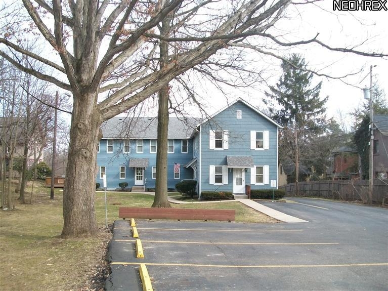
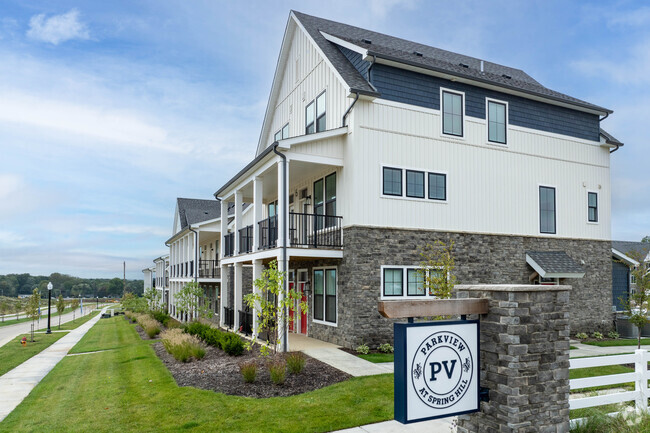
742 N Chestnut St
742 N Chestnut St,
Ravenna,
OH
44266
2 Weeks Ago
Favorites
742 N Chestnut St

Favorites
Check Back Soon for Upcoming Availability
About 742 N Chestnut St Ravenna, OH 44266
At 742 N Chestnut St in Ravenna, OH, experience stylish living. The 742 N. Chestnut St. location in Ravenna's 44266 area is an ideal place for residents. The professional leasing staff is waiting to show you all that this community has in store. Come for a visit to see the available floorplan options. Stop by the leasing office to schedule a tour.
742 N Chestnut St is an apartment community located in Portage County and the 44266 ZIP Code. This area is served by the Ravenna City attendance zone.
Fees and Policies
Details
Property Information
-
Built in 1900
-
8 units/2 stories
Location
Get Directions
Ravenna is a small city located about twenty miles east of Akron and forty miles southeast of Cleveland. Like many communities in the region, Ravenna has a rich history as an industrial town, and remains an active manufacturing center today. The city of Kent sits just west of town, and many students, faculty, and staff members from Kent State University choose to call Ravenna their home. The city is surrounded by lush nature preserves, allowing you to easily explore the region’s forests and lakes on the weekends—the gorgeous West Branch State Park and Kirwan Reservoir in particular offer a terrific venue for hiking, camping, and boating.
Learn more about living in Ravenna
Education
| Colleges & Universities | Distance | ||
|---|---|---|---|
| Colleges & Universities | Distance | ||
| Drive: | 14 min | 6.3 mi | |
| Drive: | 31 min | 21.5 mi | |
| Drive: | 35 min | 21.8 mi | |
| Drive: | 43 min | 24.5 mi |
742 N Chestnut St is within 14 minutes or 6.3 miles from Kent State University. It is also near University of Akron and Mount Union College.
Schools


Public Elementary School
Grades PK-5
438 Students
Nearby
Public Elementary School
Grades K-5
438 Students
Nearby
Public Elementary & Middle School
Grades 5-9
505 Students
Attendance Zone
Public Elementary School
Grades K
134 Students
Attendance Zone
Public Elementary School
Grades 3-4
327 Students
Attendance Zone
Public High School
Grades 9-12
582 Students
Attendance Zone
Private Elementary, Middle & High School
Grades PK-12
Nearby
Private Elementary & Middle School
Grades K-8
231 Students
Nearby
Private Elementary School
Grades PK-4
Nearby
School data provided by
 The GreatSchools Rating helps parents compare schools within a state based on a variety of school quality indicators and provides a helpful picture of how effectively each school serves all of its students. Ratings are on a scale of 1 (below average) to 10 (above average) and can include test scores, college readiness, academic progress, advanced courses, equity, discipline and attendance data. We also advise parents to visit schools, consider other information on school performance and programs, and consider family needs as part of the school selection process.
View GreatSchools Rating Methodology
View GreatSchools Rating Methodology
Transportation options available in Ravenna include Warrensville (Blue Line), located 28.7 miles from 742 N Chestnut St. 742 N Chestnut St is near Akron-Canton Regional, located 31.1 miles or 41 minutes away.
| Transit / Subway | Distance | ||
|---|---|---|---|
| Transit / Subway | Distance | ||
|
|
Drive: | 41 min | 28.7 mi |
|
|
Drive: | 41 min | 29.2 mi |
|
|
Drive: | 42 min | 29.6 mi |
|
|
Drive: | 44 min | 30.4 mi |
|
|
Drive: | 45 min | 30.5 mi |
| Commuter Rail | Distance | ||
|---|---|---|---|
| Commuter Rail | Distance | ||
| Drive: | 33 min | 18.9 mi | |
| Drive: | 31 min | 21.4 mi | |
| Drive: | 42 min | 22.7 mi | |
| Drive: | 39 min | 24.7 mi | |
| Drive: | 44 min | 25.8 mi |
| Airports | Distance | ||
|---|---|---|---|
| Airports | Distance | ||
|
Akron-Canton Regional
|
Drive: | 41 min | 31.1 mi |
Time and distance from 742 N Chestnut St.
| Shopping Centers | Distance | ||
|---|---|---|---|
| Shopping Centers | Distance | ||
| Drive: | 4 min | 1.4 mi | |
| Drive: | 5 min | 1.7 mi | |
| Drive: | 5 min | 1.9 mi |
742 N Chestnut St has 3 shopping centers within 1.9 miles, which is about a 5-minute drive. The miles and minutes will be for the farthest away property.
| Parks and Recreation | Distance | ||
|---|---|---|---|
| Parks and Recreation | Distance | ||
|
West Branch State Park
|
Drive: | 15 min | 7.5 mi |
|
Munroe Falls Metro Park
|
Drive: | 30 min | 13.5 mi |
|
Wood Hollow
|
Drive: | 25 min | 13.8 mi |
742 N Chestnut St has 3 parks within 13.8 miles, including West Branch State Park, Wood Hollow, and Munroe Falls Metro Park.
| Hospitals | Distance | ||
|---|---|---|---|
| Hospitals | Distance | ||
| Walk: | 13 min | 0.7 mi |
742 N Chestnut St is 0.7 mile and a 13 minute walk from University Hospitals Portage Medical Center.
| Military Bases | Distance | ||
|---|---|---|---|
| Military Bases | Distance | ||
| Drive: | 106 min | 84.6 mi | |
| Drive: | 109 min | 86.9 mi |
742 N Chestnut St is 84.6 miles from Mansfield Lahm Airport Air Guard Station, and is convenient to other military bases, including Pittsburgh Air Reserve Station.
You May Also Like
Similar Rentals Nearby


What Are Walk Score®, Transit Score®, and Bike Score® Ratings?
Walk Score® measures the walkability of any address. Transit Score® measures access to public transit. Bike Score® measures the bikeability of any address.
What is a Sound Score Rating?
A Sound Score Rating aggregates noise caused by vehicle traffic, airplane traffic and local sources
Responded To This Review