$1,950 / Month
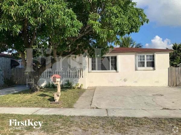
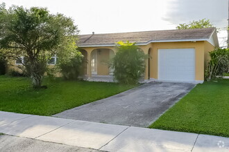
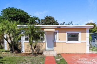
7420 SW 31st St
Miami, FL 33155
Today
Favorites
305-546-0941
-
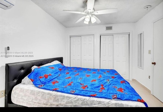
Bedrooms
1
-
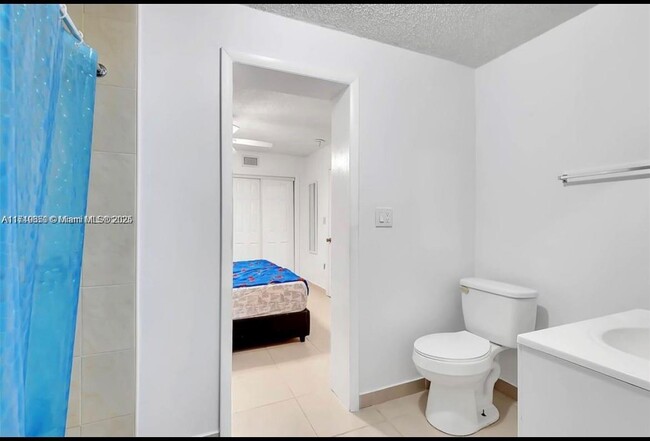
Bathrooms
1
-
Square Feet
1,711 sq ft
-
Available
Available Mar 30
Highlights
- 1 Car Garage
- 1-Story Property
7420 SW 31st St

Favorites
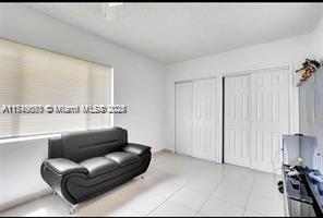
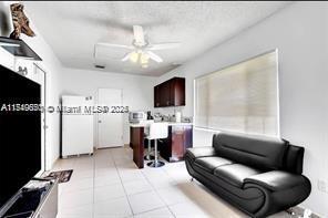
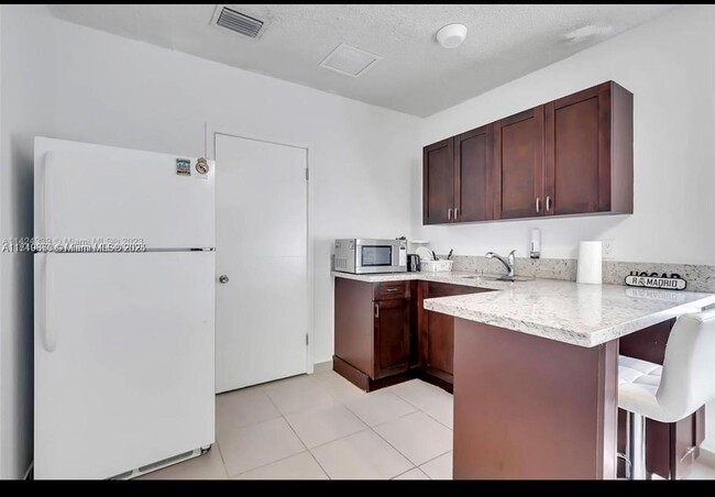
About This Home
Available Mar 30
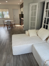
Cozy apartment on the side of the main house. First, last and secure deposit. Water and electricity are included. Please send offer along with police report, credit report, and last month paystub reports. Oly two persons are allowed.
7420 SW 31st St is a house located in Miami/Dade County and the 33155 ZIP Code. This area is served by the Miami-Dade County Public Schools attendance zone.
* Price shown is base rent and may not include non-optional fees and utilities.
Price, availability, fees, and any applicable rent special are subject to change without notice.
* Square footage definitions vary. Displayed square footage is approximate.
Home Details
Home Type
Single Family Detached Home
Year Built
Built in 1952
Accessible Home Design
Entry on the 1st floor
Bedrooms and Bathrooms
1 Full Bathroom
1 Bedroom
Interior Spaces
1,711 Sq Ft Home
1-Story Property
Listing and Financial Details
Property Available on 3/1/25
Assessor Parcel Number 30-40-14-009-4060
Lot Details
6,500 Sq Ft Lot
Property is zoned 0100
Parking
1 Car Garage
Schools
Emerson Elementary School
West Miami Middle School
Southwest Miami High School
Community Details
Overview
No Home Owners Association
Central Miami Part 7 Condos
Central Miami Part 7 Subdivision
Pet Policy
No Pets Allowed
Contact
- Listed by Maria Bourzac | MB Realty And Associates LLC
- Phone Number
- Contact
-
Source
 MIAMI Association of REALTORS®
Copyright © 2025 MIAMI Association of REALTORS®. All rights reserved. All information provided by the listing agent/broker is deemed reliable but is not guaranteed and should be independently verified.
$1,432 / month
$220,900 Listing Price
3 Beds
•2 Baths
•
1,127 Sq Ft
$1,751 / month
$270,000 Listing Price
2 Beds
•1 Baths
•
802 Sq Ft
$1,751 / month
$270,000 Listing Price
2 Beds
•1 Baths
•
561 Sq Ft
Location
Get Directions
As its name implies, Coral Terrace West consists of the western portion of Coral Terrace, a suburban community located about nine miles away from Downtown Miami. The neighborhood is also convenient to Miami International Airport, Florida International University, and the University of Miami, so it’s a great option for renters seeking a central location. Close proximity to the Palmetto Expressway and Highway 976 allows for a quick commute into the city, but multiple businesses make their home here so residents can fulfill their needs without going far. Coral Terrace West has palm trees, canals, and several parks, creating a laid-back atmosphere. AD (Doug) Barnes Park dominates the southeastern corner of Coral Terrace West. This 65-acre gem has a pool, a basketball court, a nature walk, and more. The neighborhood a wide range of rentals including colorful ranch-style houses and modern apartments and condos.
Learn more about living in Coral Terrace West
Education
| Colleges & Universities | Distance | ||
|---|---|---|---|
| Colleges & Universities | Distance | ||
| Drive: | 13 min | 5.0 mi | |
| Drive: | 14 min | 5.1 mi | |
| Drive: | 13 min | 5.5 mi | |
| Drive: | 16 min | 6.8 mi |
7420 SW 31st St is within 13 minutes or 5.0 miles from Univ. of Miami, Coral Gables. It is also near FIU, Modesto Maidique and USAHS.
Schools


Public Elementary School
Grades PK-5
301 Students
Attendance Zone
Public Middle School
Grades 6-8
655 Students
Attendance Zone
Public High School
Grades 9-12
1,507 Students
Attendance Zone
Private Elementary School
Grades PK-5
Nearby
Private Middle & High School
Grades 6-12
18 Students
Nearby
School data provided by
 The GreatSchools Rating helps parents compare schools within a state based on a variety of school quality indicators and provides a helpful picture of how effectively each school serves all of its students. Ratings are on a scale of 1 (below average) to 10 (above average) and can include test scores, college readiness, academic progress, advanced courses, equity, discipline and attendance data. We also advise parents to visit schools, consider other information on school performance and programs, and consider family needs as part of the school selection process.
View GreatSchools Rating Methodology
View GreatSchools Rating Methodology
Transportation options available in Miami include Miami Intl Airport Ground Level, located 8.5 miles from 7420 SW 31st St. 7420 SW 31st St is near Miami International, located 6.6 miles or 15 minutes away, and Fort Lauderdale/Hollywood International, located 32.8 miles or 47 minutes away.
| Transit / Subway | Distance | ||
|---|---|---|---|
| Transit / Subway | Distance | ||
|
|
Drive: | 18 min | 8.5 mi |
|
|
Drive: | 20 min | 8.9 mi |
|
|
Drive: | 20 min | 9.1 mi |
|
|
Drive: | 20 min | 9.4 mi |
|
|
Drive: | 20 min | 9.5 mi |
| Commuter Rail | Distance | ||
|---|---|---|---|
| Commuter Rail | Distance | ||
|
|
Drive: | 11 min | 4.5 mi |
|
|
Drive: | 11 min | 4.7 mi |
|
|
Drive: | 12 min | 4.8 mi |
|
|
Drive: | 12 min | 4.9 mi |
|
|
Drive: | 11 min | 6.0 mi |
| Airports | Distance | ||
|---|---|---|---|
| Airports | Distance | ||
|
Miami International
|
Drive: | 15 min | 6.6 mi |
|
Fort Lauderdale/Hollywood International
|
Drive: | 47 min | 32.8 mi |
Time and distance from 7420 SW 31st St.
| Shopping Centers | Distance | ||
|---|---|---|---|
| Shopping Centers | Distance | ||
| Walk: | 16 min | 0.9 mi | |
| Walk: | 17 min | 0.9 mi | |
| Drive: | 4 min | 1.3 mi |
7420 SW 31st St has 3 shopping centers within 1.3 miles, which is about a 4-minute walk. The miles and minutes will be for the farthest away property.
| Parks and Recreation | Distance | ||
|---|---|---|---|
| Parks and Recreation | Distance | ||
|
Sense of Wonder Nature Center and A.D. Barnes Park
|
Walk: | 20 min | 1.1 mi |
|
Gifford Arboretum
|
Drive: | 9 min | 3.7 mi |
|
The Barnacle Historic State Park
|
Drive: | 14 min | 5.8 mi |
|
The Kampong
|
Drive: | 14 min | 6.1 mi |
|
Fairchild Tropical Botanic Garden
|
Drive: | 20 min | 7.9 mi |
7420 SW 31st St has 5 parks within 7.9 miles, including Sense of Wonder Nature Center and A.D. Barnes Park, Gifford Arboretum, and The Kampong.
| Hospitals | Distance | ||
|---|---|---|---|
| Hospitals | Distance | ||
| Walk: | 11 min | 0.6 mi | |
| Drive: | 6 min | 2.4 mi | |
| Drive: | 11 min | 4.0 mi |
7420 SW 31st St has 3 hospitals within 4.0 miles, the nearest is Westchester General Hospital which is 0.6 mile away and a 11 minute walk.
You May Also Like
Similar Rentals Nearby

What Are Walk Score®, Transit Score®, and Bike Score® Ratings?
Walk Score® measures the walkability of any address. Transit Score® measures access to public transit. Bike Score® measures the bikeability of any address.
What is a Sound Score Rating?
A Sound Score Rating aggregates noise caused by vehicle traffic, airplane traffic and local sources

7420 SW 31st St
Miami, FL 33155