75 Peterborough St
75 Peterborough St,
Boston,
MA
02215
2 Weeks Ago
Favorites
75 Peterborough St

Favorites
Check Back Soon for Upcoming Availability
About 75 Peterborough St Boston, MA 02215
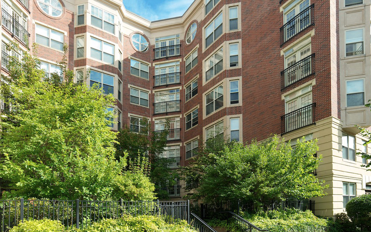
~ New construction in a historic neighborhood, Landmark Square was designed to dovetail with the vintage look of its surrounding apartment communities. Behind its classic façade, however, the building’s 132 apartments offer residents modern comforts alongside elegant design. A private courtyard, underground garage, and full-service concierge all serve to make living at Landmark effortlessly simple.
75 Peterborough St is an apartment community located in Suffolk County and the 02215 ZIP Code.
Property Address:
75 Peterborough St,
Boston,
MA
02215
Tree-filled, historic, and packed with educational opportunity, there's no other neighborhood quite like Fenway. The neighborhood may be most well-known for its titular attraction, Fenway Park, home of the Boston Red Sox. However, the area is also renowned for its sprawling greenspace. The name "Fenway" refers to the neighborhood’s lush parkway and tree-filled paths that wind lazily through the area, forming part of Frederick Law Olmsted’s “Emerald Necklace Plan” (a chain of parks throughout Boston). The Fenway opened in 1876, and its route includes the Museum of Fine Arts and the Isabella Steward Gardner Museum.
Learn more about living in FenwayBelow are rent ranges for similar nearby apartments
| Beds | Average Size | Lowest | Typical | Premium |
|---|---|---|---|---|
| Studio Studio Studio | 2388-2389 Sq Ft | $1,600 | $2,562 | $9,357 |
| 1 Bed 1 Bed 1 Bed | 2826-2828 Sq Ft | $1,200 | $3,290 | $9,714 |
| 2 Beds 2 Beds 2 Beds | 3567-3569 Sq Ft | $1,500 | $4,015 | $20,922 |
| 3 Beds 3 Beds 3 Beds | 4100-4101 Sq Ft | $1,425 | $5,029 | $10,390 |
| 4 Beds 4 Beds 4 Beds | 5608-5609 Sq Ft | $4,500 | $7,514 | $12,000 |
Education
| Colleges & Universities | Distance | ||
|---|---|---|---|
| Colleges & Universities | Distance | ||
| Walk: | 9 min | 0.5 mi | |
| Walk: | 9 min | 0.5 mi | |
| Walk: | 10 min | 0.6 mi | |
| Drive: | 2 min | 1.2 mi |
75 Peterborough St is within 9 minutes or 0.5 mile from Simmons College. It is also near Emmanuel College and Lesley Univ., Art Institute.
Transportation options available in Boston include Fenway Station, located 0.5 mile from 75 Peterborough St. 75 Peterborough St is near General Edward Lawrence Logan International, located 6.3 miles or 14 minutes away.
| Transit / Subway | Distance | ||
|---|---|---|---|
| Transit / Subway | Distance | ||
|
|
Walk: | 9 min | 0.5 mi |
|
|
Walk: | 10 min | 0.5 mi |
|
|
Walk: | 12 min | 0.6 mi |
|
|
Walk: | 12 min | 0.6 mi |
|
|
Drive: | 3 min | 1.4 mi |
| Commuter Rail | Distance | ||
|---|---|---|---|
| Commuter Rail | Distance | ||
|
|
Drive: | 3 min | 1.5 mi |
|
|
Drive: | 7 min | 1.8 mi |
| Drive: | 6 min | 2.6 mi | |
|
|
Drive: | 7 min | 3.2 mi |
|
|
Drive: | 8 min | 4.1 mi |
| Airports | Distance | ||
|---|---|---|---|
| Airports | Distance | ||
|
General Edward Lawrence Logan International
|
Drive: | 14 min | 6.3 mi |
Time and distance from 75 Peterborough St.
| Shopping Centers | Distance | ||
|---|---|---|---|
| Shopping Centers | Distance | ||
| Walk: | 8 min | 0.4 mi | |
| Walk: | 12 min | 0.7 mi | |
| Drive: | 9 min | 5.1 mi |
75 Peterborough St has 3 shopping centers within 5.1 miles, which is about a 9-minute drive. The miles and minutes will be for the farthest away property.
| Parks and Recreation | Distance | ||
|---|---|---|---|
| Parks and Recreation | Distance | ||
|
Charles River Reservation
|
Drive: | 3 min | 1.3 mi |
|
Coit Observatory
|
Drive: | 3 min | 1.4 mi |
|
John Fitzgerald Kennedy National Historic Site
|
Drive: | 4 min | 1.8 mi |
|
Boston Public Garden
|
Drive: | 6 min | 2.1 mi |
|
Roxbury Heritage State Park
|
Drive: | 5 min | 2.2 mi |
75 Peterborough St has 5 parks within 2.2 miles, including Charles River Reservation, Coit Observatory, and Roxbury Heritage State Park.
| Hospitals | Distance | ||
|---|---|---|---|
| Hospitals | Distance | ||
| Walk: | 9 min | 0.5 mi | |
| Walk: | 13 min | 0.7 mi | |
| Drive: | 2 min | 1.2 mi |
75 Peterborough St has 3 hospitals within 1.2 miles, the nearest is Beth Israel Deaconess Medical Center which is 0.5 mile away and a 9 minutes drive.
| Military Bases | Distance | ||
|---|---|---|---|
| Military Bases | Distance | ||
| Drive: | 28 min | 14.7 mi | |
| Drive: | 27 min | 15.7 mi |
75 Peterborough St is 14.7 miles from Hanscom Air Force Base, and is convenient to other military bases, including US Military Reservation.
You May Also Like
Similar Rentals Nearby


What Are Walk Score®, Transit Score®, and Bike Score® Ratings?
Walk Score® measures the walkability of any address. Transit Score® measures access to public transit. Bike Score® measures the bikeability of any address.
What is a Sound Score Rating?
A Sound Score Rating aggregates noise caused by vehicle traffic, airplane traffic and local sources