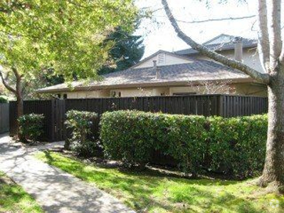
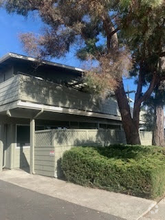
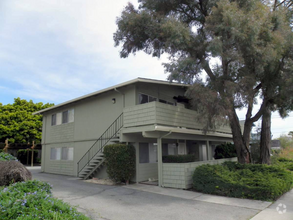
7555 Sunset Way Unit 4
Aptos, CA 95003
Favorites

7555 Sunset Way Unit 4
Favorites
Check Back Soon for Upcoming Availability
| Beds | Baths | Average SF |
|---|---|---|
| 2 Bedrooms 2 Bedrooms 2 Br | 1.5 Baths 1.5 Baths 1.5 Ba | 1,020 SF |
About This Property
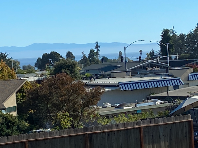
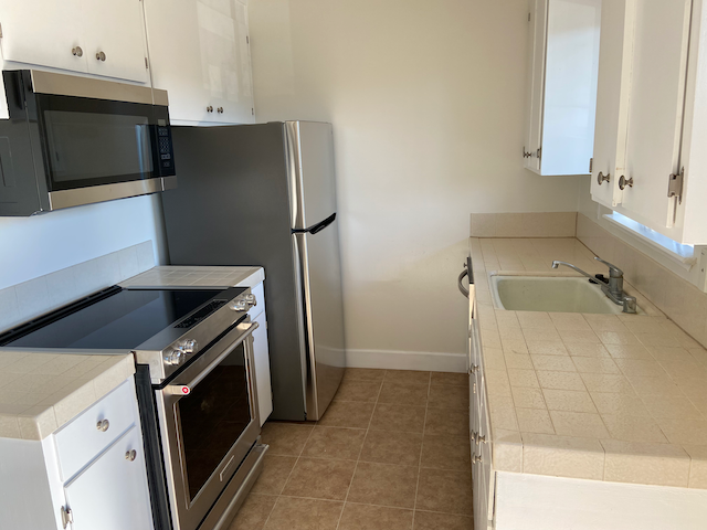
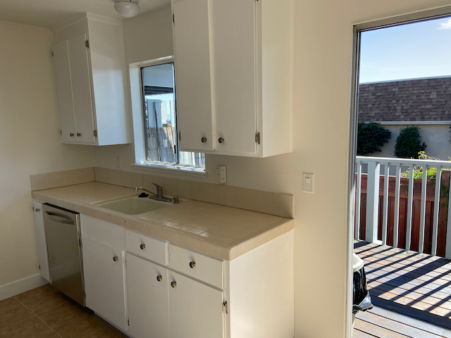
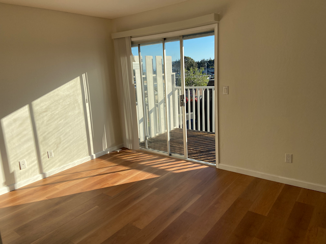
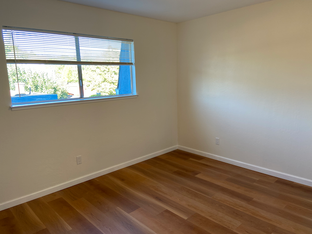
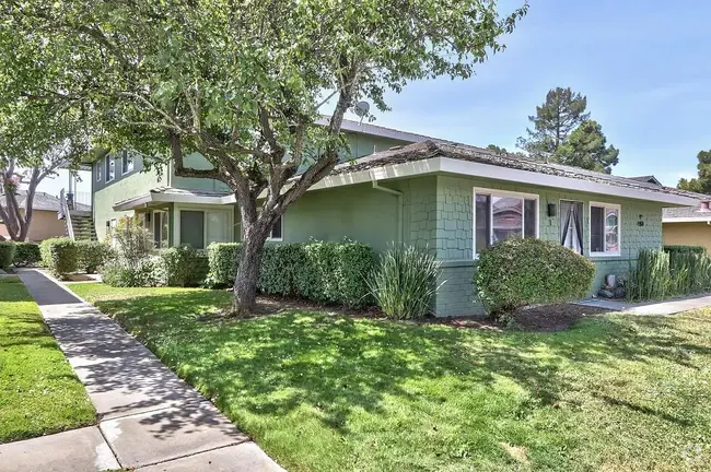
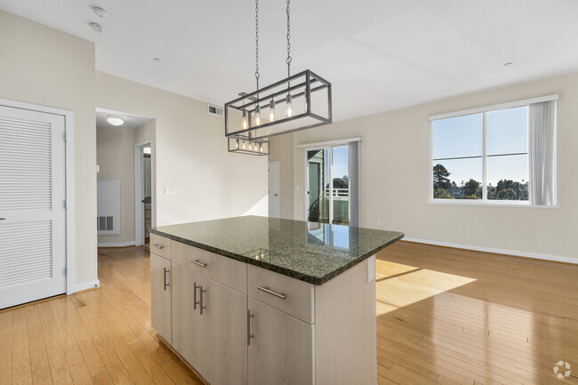
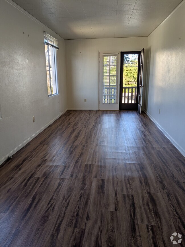
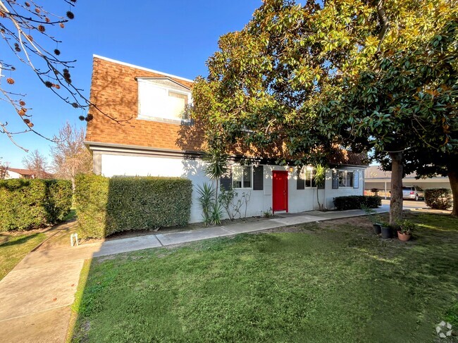
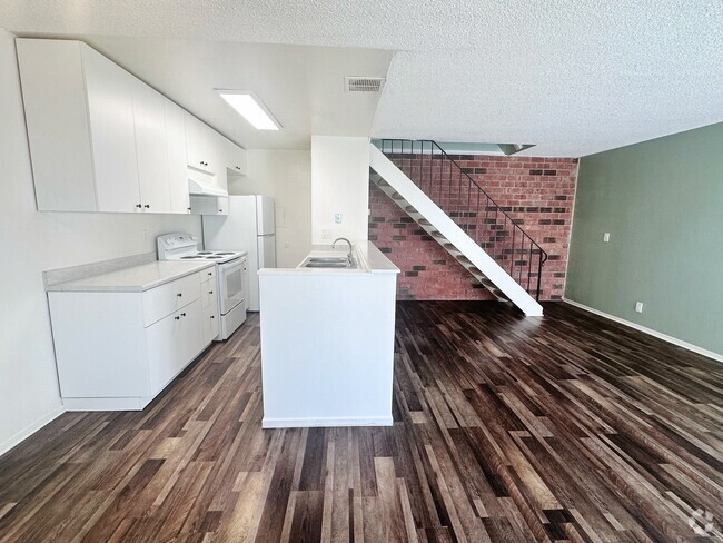
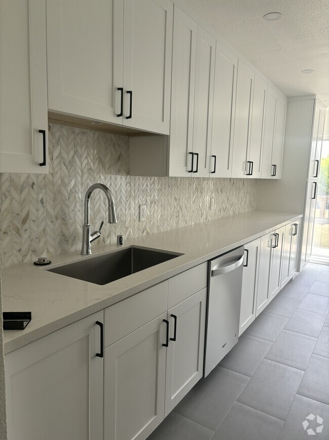
Property Id: 1004554 All new appliances. New laminate flooring in living room and bedrooms. New tile floors in the kitchen and both bathrooms. New porcelain-coated steel bathtub. All walls freshly painted. Outdoor decks on both floors, with "peek of ocean" views and nice sunsets. One reserved covered parking space; other not-reserved spaces usually available for your second car. On-site laundromat. The HOA takes care of landscaping. The whole complex is pleasant and quiet. An entrance to Nisene Marks State Park is two blocks away. It is a short walk or two-minute bike ride to Seacliff State Beach. There are many good restaurants within a five-minute walk, including Mexican, Indian, Mediterranean, Marianne's ice cream and two coffee shops. Open House: Saturday Oct 8 and Sunday Oct 9, 1:30 to 3:30 pm. We are seeking tenants who will take good care of this freshly remodeled apartment and make their home here for some time.
7555 Sunset Way is a condo located in Santa Cruz County and the 95003 ZIP Code. This area is served by the Pajaro Valley Unified attendance zone.
Condo Features
Dishwasher
Microwave
Refrigerator
Disposal
- Cable Ready
- Dishwasher
- Disposal
- Microwave
- Oven
- Refrigerator
- Tile Floors
Fees and Policies
The fees below are based on community-supplied data and may exclude additional fees and utilities.
- Dogs Allowed
-
Fees not specified
-
Weight limit--
-
Pet Limit--
- Parking
-
Garage--
Details
Utilities Included
-
Water
-
Trash Removal
-
Sewer
Property Address:
7555 Sunset Way,
Aptos,
CA
95003
 This Property
 Available Property
Overlooking Monterey Bay and home to the gorgeous Seacliff State Beach, Aptos provides amazing ocean views -- or the forest if you prefer, bordered on northeast side by the Forest of Nisene Marks State Park. This redwood forest begins at sea level and extends into the coastal mountains, providing 30 miles of hiking trails. The park is also terrific for camping, picnicking, and wildlife viewing.
At the other side of Aptos, Seacliff State Beach is perfect for surfing, beachcombing, swimming, and fishing. It also features a fishing pier with an unusual feature -- a concrete ship named the SS Palo Alto, a WWI ship that was built toward the end of the war -- too late for use. It was towed to its current location and allowed to sink where it now serves as an artificial reef. Aptos is located about seven miles east of Santa Cruz and roughly one hour south of San Jose.
Learn more about living in Aptos
Amenities
- Cable Ready
- Dishwasher
- Disposal
- Microwave
- Oven
- Refrigerator
- Tile Floors
Expenses
Utilities Included
Water, Trash Removal, Sewer
Included
Education
| Colleges & Universities | Distance | ||
|---|---|---|---|
| Colleges & Universities | Distance | ||
| Drive: | 2 min | 1.2 mi | |
| Drive: | 21 min | 11.8 mi | |
| Drive: | 44 min | 30.2 mi | |
| Drive: | 47 min | 33.9 mi |
7555 Sunset Way Unit 4 is within 2 minutes or 1.2 miles from Cabrillo College. It is also near UC Santa Cruz and Gavilan College, Gilroy.
Schools
Public Elementary & Middle School
Grades K-8
3 Students
Nearby
Public Elementary School
Grades K-6
344 Students
Attendance Zone
4
Out of 10
Public Middle School
Grades 7-8
594 Students
Attendance Zone
5
Out of 10
Public High School
Grades 9-12
1,360 Students
Attendance Zone
7
Out of 10
Private Elementary, Middle & High School
Grades PK-12
Nearby
School data provided by
GreatSchools
The GreatSchools Rating helps parents compare schools within a state based on a variety of school quality indicators and provides a helpful picture of how effectively each school serves all of its students. Ratings are on a scale of 1 (below average) to 10 (above average) and can include test scores, college readiness, academic progress, advanced courses, equity, discipline and attendance data. We also advise parents to visit schools, consider other information on school performance and programs, and consider family needs as part of the school selection process.
Transportation options available in Aptos include Ohlone/Chynoweth Station, located 34.8 miles from 7555 Sunset Way Unit 4. 7555 Sunset Way Unit 4 is near Monterey Regional, located 36.2 miles or 44 minutes away, and Norman Y Mineta San Jose International, located 37.2 miles or 49 minutes away.
| Transit / Subway | Distance | ||
|---|---|---|---|
| Transit / Subway | Distance | ||
|
|
Drive: | 47 min | 34.8 mi |
|
|
Drive: | 47 min | 35.6 mi |
|
|
Drive: | 52 min | 38.3 mi |
|
|
Drive: | 51 min | 38.8 mi |
|
|
Drive: | 52 min | 39.8 mi |
| Commuter Rail | Distance | ||
|---|---|---|---|
| Commuter Rail | Distance | ||
| Drive: | 45 min | 28.1 mi | |
| Drive: | 51 min | 31.6 mi | |
| Drive: | 55 min | 32.2 mi | |
| Drive: | 50 min | 37.5 mi | |
| Drive: | 51 min | 37.7 mi |
| Airports | Distance | ||
|---|---|---|---|
| Airports | Distance | ||
|
Monterey Regional
|
Drive: | 44 min | 36.2 mi |
|
Norman Y Mineta San Jose International
|
Drive: | 49 min | 37.2 mi |
Time and distance from 7555 Sunset Way Unit 4.
| Shopping Centers | Distance | ||
|---|---|---|---|
| Shopping Centers | Distance | ||
| Walk: | 4 min | 0.3 mi | |
| Walk: | 5 min | 0.3 mi | |
| Walk: | 6 min | 0.3 mi |
7555 Sunset Way Unit 4 has 3 shopping centers within 0.3 mile, which is about a 6-minute walk. The miles and minutes will be for the farthest away property.
| Parks and Recreation | Distance | ||
|---|---|---|---|
| Parks and Recreation | Distance | ||
|
Seacliff State Beach
|
Walk: | 16 min | 0.8 mi |
|
New Brighton State Beach
|
Drive: | 7 min | 2.7 mi |
|
The Forest of Nisene Marks State Park
|
Drive: | 10 min | 2.8 mi |
|
Arana Gulch
|
Drive: | 8 min | 5.6 mi |
|
Twin Lakes State Beach
|
Drive: | 10 min | 6.0 mi |
7555 Sunset Way Unit 4 has 5 parks within 6.0 miles, including Seacliff State Beach, The Forest of Nisene Marks State Park, and New Brighton State Beach.
| Hospitals | Distance | ||
|---|---|---|---|
| Hospitals | Distance | ||
| Drive: | 6 min | 4.6 mi | |
| Drive: | 7 min | 5.0 mi | |
| Drive: | 11 min | 8.4 mi |
7555 Sunset Way Unit 4 has 3 hospitals within 8.4 miles, the nearest is Dominican Hospital which is 4.6 miles away and a 6 minutes drive.
| Military Bases | Distance | ||
|---|---|---|---|
| Military Bases | Distance | ||
| Drive: | 52 min | 38.8 mi |
7555 Sunset Way Unit 4 is 38.8 miles and a 52 minutes from Coast Guard Facilities.
You May Also Like
Similar Rentals Nearby
-
-
 $4,4002 Beds, 2 Baths, 1,089 sq ftCondo for Rent
 -
 $3,7002 Beds, 1 Bath, 1,000 sq ftApartment for Rent
 -
 $3,2002 Beds, 1 Bath, 978 sq ftCondo for Rent
 -
 $2,4952 Beds, 1 Bath, 800 sq ftApartment for Rent
 -
 $2,7402 Beds, 1 Bath, 920 sq ftApartment for Rent
 -
 $2,6002 Beds, 1 Bath, 903 sq ftApartment for Rent
 -
 $2,9752 Beds, 1 Bath, 959 sq ftCondo for Rent
 -
 $2,8002 Beds, 1 Bath, 800 sq ftApartment for Rent
 -
 $2,8002 Beds, 1 Bath, 800 sq ftApartment for Rent
What Are Walk Score®, Transit Score®, and Bike Score® Ratings?
Walk Score® measures the walkability of any address. Transit Score® measures access to public transit. Bike Score® measures the bikeability of any address.
What is a Sound Score Rating?
A Sound Score Rating aggregates noise caused by vehicle traffic, airplane traffic and local sources

7555 Sunset Way
Aptos, CA 95003