
$1,750 / Month
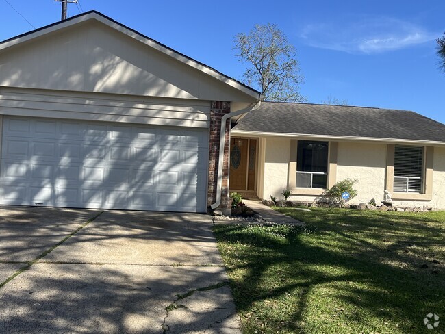
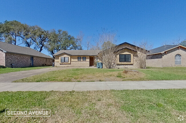
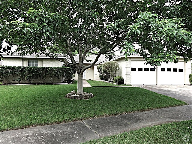
7910 Carrie Ln
Pearland, TX 77584
Today
Favorites
832-878-7380
-
Bedrooms
3
-
Bathrooms
1
-
Square Feet
--
-
Available
Available Now
Highlights
- Vaulted Ceiling
- Granite Countertops
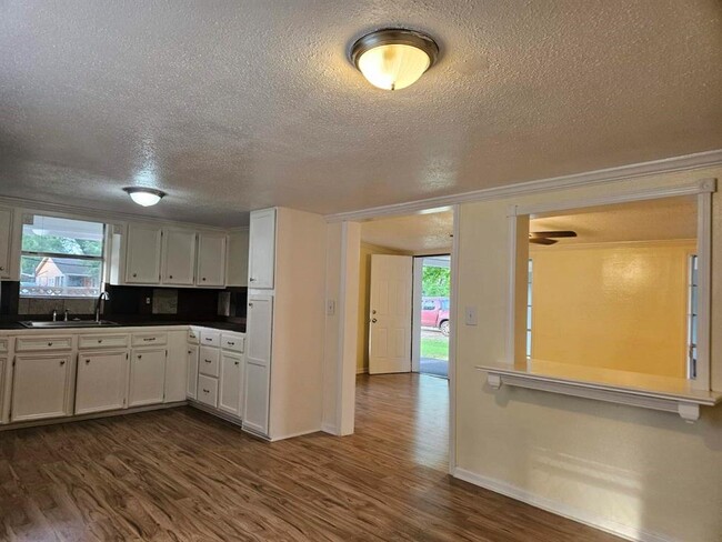
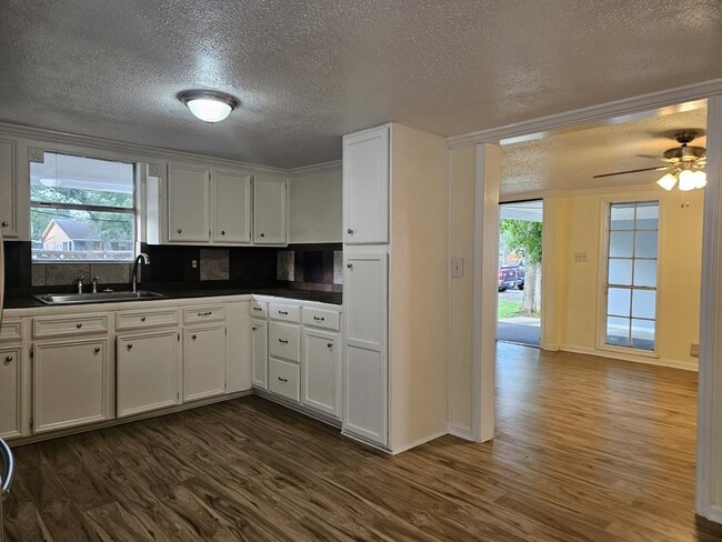
- Breakfast Room
- Family Room Off Kitchen
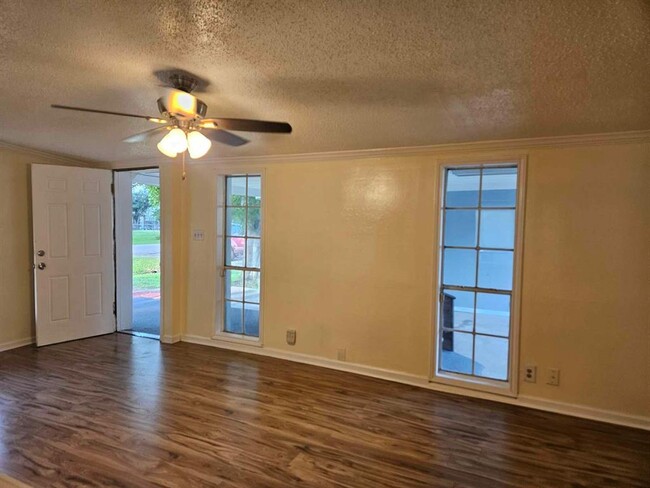
- Living Room
- Wheelchair Access
7910 Carrie Ln

Favorites
About This Home
Available Now
Beautiful 3/4 Bedrooms Home For Rent, Check out this property with a lot of upgrades and Huge back yard to raise your own Chickens, Grow your own Fruits and Vegetable or have a nice Family Gathering, Enjoy the Country Living when you are in the City near to all kind of Stores and Shopping plus Easy Access to Major Roads and Good Schools. This one is a must see.
7910 Carrie Ln is a house located in Brazoria County and the 77584 ZIP Code. This area is served by the Alvin Independent attendance zone.
* Price shown is base rent and may not include non-optional fees and utilities.
Price, availability, fees, and any applicable rent special are subject to change without notice.
* Square footage definitions vary. Displayed square footage is approximate.
Home Details
Home Type
Single Family Detached Home
Year Built
Built in 1980
Accessible Home Design
Wheelchair Access
Handicap Accessible
Bedrooms and Bathrooms
1 Full Bathroom
3 Bedrooms
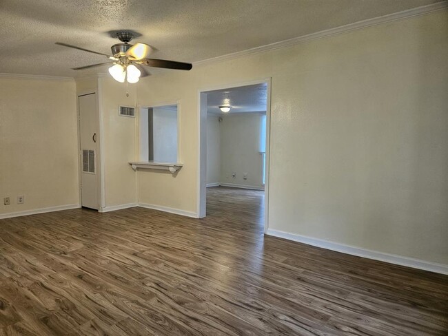
Interior Spaces
Vaulted Ceiling
Breakfast Room
Family Room Off Kitchen
Living Room
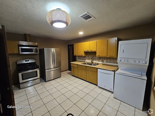
Ceiling Fan
Laminate Flooring
1,272 Sq Ft Home
1-Story Property
Kitchen
Granite Countertops
Electric Range
Electric Oven
Ice Maker
Laundry
Washer and Electric Dryer Hookup
Listing and Financial Details
Property Available on 4/28/25
Long Term Lease
Lot Details
10,019 Sq Ft Lot
Back Yard Fenced
Cleared Lot
Parking
2 Attached Carport Spaces
Additional Parking
Schools
Mark Twain Elementary School
G W Harby J H Middle School
Manvel High School
Utilities
Central Heating and Cooling System
Community Details
Overview
Flora Add Subdivision
Pet Policy
The building has rules on how big a pet can be within a unit
Pet Deposit Required
Fees and Policies
Contact
- Listed by Maria Goodly | Realty Associates
- Phone Number
- Contact
-
Source
 Houston Association of REALTORS®
Copyright © 2025 Houston Association of Realtors. All rights reserved. All information provided by the listing agent/broker is deemed reliable but is not guaranteed and should be independently verified.
Location
Get Directions
Amenities
- Smoke Free
Pearland is consistently ranked as one of the fastest-growing cities in Texas every year. Nestled about 17 miles south of Downtown Houston and 15 miles east of the NASA Johnson Space Center, Pearland provides residents with access to all that the Greater Houston area has to offer in addition to the quintessential suburban experience.
Shoppers rejoice at the vast array of stores present in the outdoor Pearland Town Center. Baybrook Mall and Almeda Mall are also within close proximity to Pearland for additional retail delights. Golfers have their pick of where to practice their swing with Clear Creek Golf Club, Southwyck Golf Club, and Golfcrest Country Club all located near Pearland. Centennial Park supplies Pearland residents with a disc golf course, dog park, and playground. Sri Meenakshi Devasthanam delivers an in-depth experience of Indian culture with regular events and service.
Learn more about living in Pearland
Education
| Colleges & Universities | Distance | ||
|---|---|---|---|
| Colleges & Universities | Distance | ||
| Drive: | 22 min | 10.2 mi | |
| Drive: | 21 min | 10.9 mi | |
| Drive: | 33 min | 16.0 mi | |
| Drive: | 38 min | 21.8 mi |
7910 Carrie Ln is within 22 minutes or 10.2 miles from San Jacinto College, South. It is also near Alvin Community College and Univ. of Houston Clear Lake.
Schools


Public Elementary School
Grades PK-5
670 Students
Attendance Zone
Public Middle School
Grades 6-8
610 Students
Attendance Zone
Public High School
Grades 9-12
2,607 Students
Attendance Zone
Private Elementary & Middle School
Grades PK-8
Nearby
Private Elementary, Middle & High School
Grades PK-12
254 Students
Nearby
School data provided by
 The GreatSchools Rating helps parents compare schools within a state based on a variety of school quality indicators and provides a helpful picture of how effectively each school serves all of its students. Ratings are on a scale of 1 (below average) to 10 (above average) and can include test scores, college readiness, academic progress, advanced courses, equity, discipline and attendance data. We also advise parents to visit schools, consider other information on school performance and programs, and consider family needs as part of the school selection process.
View GreatSchools Rating Methodology
View GreatSchools Rating Methodology
Transportation options available in Pearland include Palm Center Transit Ctr Sb, located 16.4 miles from 7910 Carrie Ln. 7910 Carrie Ln is near William P Hobby, located 12.7 miles or 29 minutes away, and George Bush Intcntl/Houston, located 43.4 miles or 64 minutes away.
| Transit / Subway | Distance | ||
|---|---|---|---|
| Transit / Subway | Distance | ||
| Drive: | 33 min | 16.4 mi | |
| Drive: | 35 min | 17.3 mi | |
| Drive: | 35 min | 19.2 mi | |
|
|
Drive: | 36 min | 20.4 mi |
|
|
Drive: | 37 min | 21.3 mi |
| Commuter Rail | Distance | ||
|---|---|---|---|
| Commuter Rail | Distance | ||
|
|
Drive: | 41 min | 23.7 mi |
| Airports | Distance | ||
|---|---|---|---|
| Airports | Distance | ||
|
William P Hobby
|
Drive: | 29 min | 12.7 mi |
|
George Bush Intcntl/Houston
|
Drive: | 64 min | 43.4 mi |
Time and distance from 7910 Carrie Ln.
| Shopping Centers | Distance | ||
|---|---|---|---|
| Shopping Centers | Distance | ||
| Drive: | 14 min | 6.1 mi | |
| Drive: | 15 min | 6.4 mi | |
| Drive: | 16 min | 6.9 mi |
7910 Carrie Ln has 3 shopping centers within 6.9 miles, which is about a 16-minute drive. The miles and minutes will be for the farthest away property.
| Parks and Recreation | Distance | ||
|---|---|---|---|
| Parks and Recreation | Distance | ||
|
Scuba Park
|
Drive: | 18 min | 8.4 mi |
|
Bayou Wildlife Zoo
|
Drive: | 23 min | 11.8 mi |
7910 Carrie Ln has 2 parks within 11.8 miles, including Scuba Park, and Bayou Wildlife Zoo.
| Hospitals | Distance | ||
|---|---|---|---|
| Hospitals | Distance | ||
| Drive: | 25 min | 13.0 mi | |
| Drive: | 26 min | 13.1 mi | |
| Drive: | 27 min | 13.7 mi |
7910 Carrie Ln has 3 hospitals within 13.7 miles, the nearest is Hca Houston Healthcare Pearland which is 13.0 miles away and a 25 minute drive.
| Military Bases | Distance | ||
|---|---|---|---|
| Military Bases | Distance | ||
| Drive: | 33 min | 16.2 mi | |
| Drive: | 63 min | 40.4 mi |
7910 Carrie Ln is 16.2 miles from Lyndon B Johnson Space Center, and is convenient to other military bases, including Pelican Spit Military Reservation.
You May Also Like
Similar Rentals Nearby

What Are Walk Score®, Transit Score®, and Bike Score® Ratings?
Walk Score® measures the walkability of any address. Transit Score® measures access to public transit. Bike Score® measures the bikeability of any address.
What is a Sound Score Rating?
A Sound Score Rating aggregates noise caused by vehicle traffic, airplane traffic and local sources
7910 Carrie Ln
Pearland, TX 77584