-
Monthly Rent
$1,550
-
Bedrooms
1 bd
-
Bathrooms
1 ba
-
Square Feet
600 sq ft
Details

About This Property
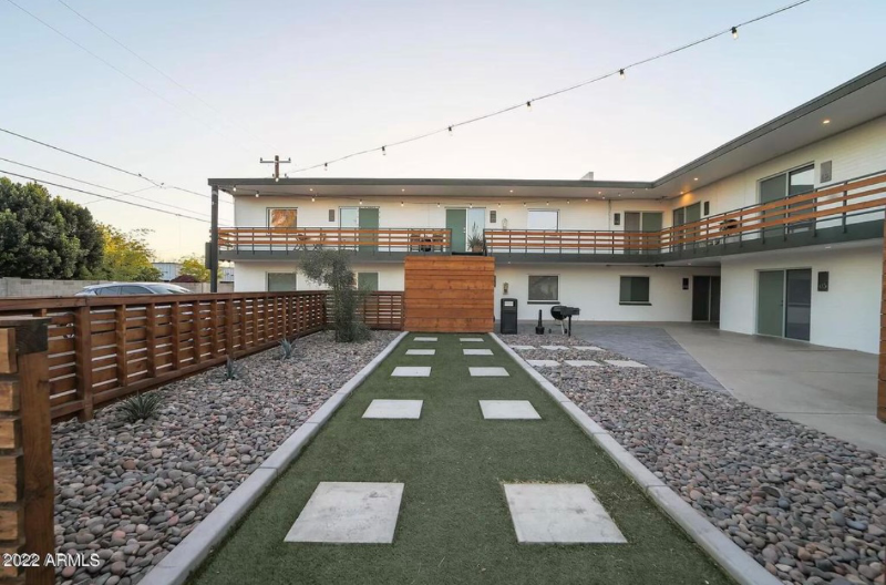
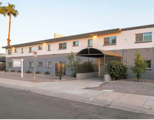
Property Id: 1013937 1+1 + yard. * PRIME LOCATION *Newly renovated. *Brand new carpet. * In unit laundry, * A back yard (dog ok). * 2 large closets and a coat closet. *Very clean and quiet. * 1 private parking spot and plenty of street parking. * Lots of natural light * Open concept *Clean, fresh and quiet. Live maintenance and hassle free, in the midst of the popular community of Uptown Phoenix, Camelback Corridor and Restaurant Row. Trendy apartment complex with clean lines and a modern mid century style architecture. You'll be just minutes from the Biltmore retail and financial district. This apartment is close to Grand Canyon University. Its location accommodates easy access to the Arizona State Route 51, connecting to the 101 Loop. Being located on a quiet street, also provides the perfect opportunity for working from your home office. Easy access to the 51 and Interstate 17. Located on a quiet street in a peaceful complex.
813 E Marlette Ave is an apartment community located in Maricopa County and the 85014 ZIP Code.
Features
Washer/Dryer
Microwave
Refrigerator
Disposal
- Washer/Dryer
- Cable Ready
- Security System
- Disposal
- Microwave
- Oven
- Refrigerator
- Bicycle Storage
- Fenced Lot
Fees and Policies
The fees below are based on community-supplied data and may exclude additional fees and utilities.
- Dogs Allowed
-
Fees not specified
- Cats Allowed
-
Fees not specified
Details
Utilities Included
-
Trash Removal
 This Property
 Available Property
- Washer/Dryer
- Cable Ready
- Security System
- Disposal
- Microwave
- Oven
- Refrigerator
- Fenced Lot
- Bicycle Storage
North Phoenix refers to the vast swath of land that stretches from Bethany Home Road up towards the Phoenix mountains. Bounded to the east by State Route 51 and to the west by 51st Avenue, North Phoenix is home a slew of diverse communities and neighborhoods all offering a variety of rentals ranging from the upscale to the more affordable. There are numerous golf courses and of course the mountains that offer residents a number of outdoor activities to engage in. For shopping and dining, residents head to Desert Ridge Marketplace on High Street, which is filled with upscale boutiques, nightlife hotspots, restaurants, and more. Interstate 17 and Route 101 make commuting around this desirable area simple.
Learn more about living in North Phoenix| Colleges & Universities | Distance | ||
|---|---|---|---|
| Colleges & Universities | Distance | ||
| Drive: | 11 min | 4.6 mi | |
| Drive: | 13 min | 5.0 mi | |
| Drive: | 11 min | 5.1 mi | |
| Drive: | 12 min | 5.3 mi |
Transportation options available in Phoenix include Central Ave/Camelback, located 2.5 miles from 813 E Marlette Ave Unit 4. 813 E Marlette Ave Unit 4 is near Phoenix Sky Harbor International, located 9.9 miles or 18 minutes away, and Phoenix-Mesa Gateway, located 36.7 miles or 50 minutes away.
| Transit / Subway | Distance | ||
|---|---|---|---|
| Transit / Subway | Distance | ||
|
|
Drive: | 6 min | 2.5 mi |
|
|
Drive: | 6 min | 2.6 mi |
|
|
Drive: | 6 min | 2.6 mi |
|
|
Drive: | 6 min | 2.8 mi |
|
|
Drive: | 6 min | 3.0 mi |
| Commuter Rail | Distance | ||
|---|---|---|---|
| Commuter Rail | Distance | ||
|
|
Drive: | 50 min | 37.7 mi |
| Airports | Distance | ||
|---|---|---|---|
| Airports | Distance | ||
|
Phoenix Sky Harbor International
|
Drive: | 18 min | 9.9 mi |
|
Phoenix-Mesa Gateway
|
Drive: | 50 min | 36.7 mi |
Time and distance from 813 E Marlette Ave Unit 4.
| Shopping Centers | Distance | ||
|---|---|---|---|
| Shopping Centers | Distance | ||
| Walk: | 6 min | 0.3 mi | |
| Walk: | 8 min | 0.4 mi | |
| Walk: | 9 min | 0.5 mi |
| Parks and Recreation | Distance | ||
|---|---|---|---|
| Parks and Recreation | Distance | ||
|
Desert Storm Park
|
Drive: | 5 min | 2.2 mi |
|
Steele Indian School Park
|
Drive: | 7 min | 2.8 mi |
|
Granada Park
|
Drive: | 7 min | 3.1 mi |
|
Tonto National Forest
|
Drive: | 11 min | 4.7 mi |
|
Dreamy Draw Recreation Area
|
Drive: | 12 min | 7.3 mi |
| Hospitals | Distance | ||
|---|---|---|---|
| Hospitals | Distance | ||
| Drive: | 6 min | 2.5 mi | |
| Drive: | 6 min | 2.7 mi | |
| Drive: | 7 min | 3.1 mi |
| Military Bases | Distance | ||
|---|---|---|---|
| Military Bases | Distance | ||
| Drive: | 18 min | 9.7 mi | |
| Drive: | 35 min | 17.9 mi | |
| Drive: | 107 min | 79.0 mi |
You May Also Like
What Are Walk Score®, Transit Score®, and Bike Score® Ratings?
Walk Score® measures the walkability of any address. Transit Score® measures access to public transit. Bike Score® measures the bikeability of any address.
What is a Sound Score Rating?
A Sound Score Rating aggregates noise caused by vehicle traffic, airplane traffic and local sources


