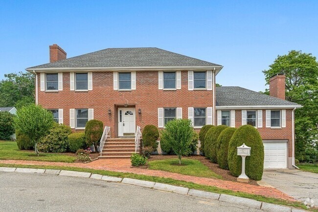
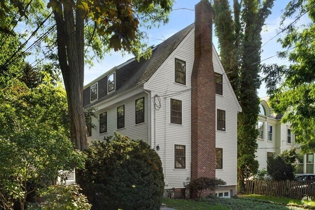
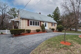
82 Main St
Lynnfield, MA 01940
Favorites

82 Main St
Favorites
Check Back Soon for Upcoming Availability
| Beds | Baths | Average SF |
|---|---|---|
| 4 Bedrooms 4 Bedrooms 4 Br | 1.5 Baths 1.5 Baths 1.5 Ba | 1,906 SF |
About This Property
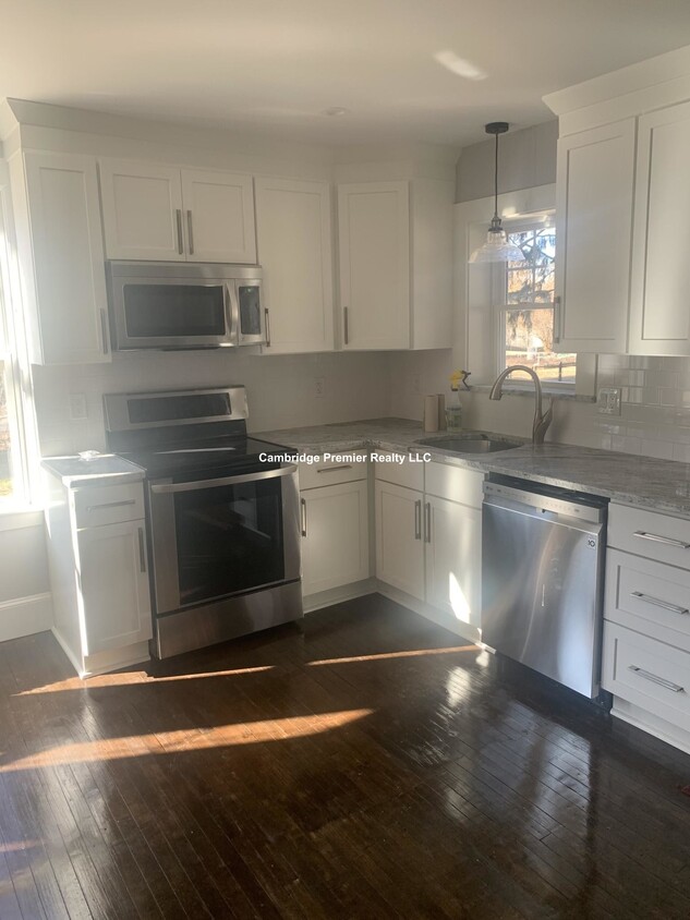
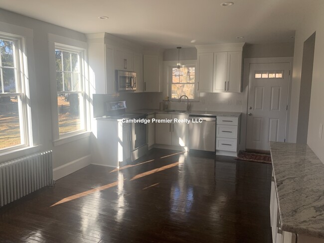
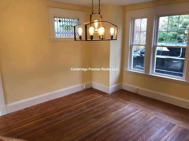
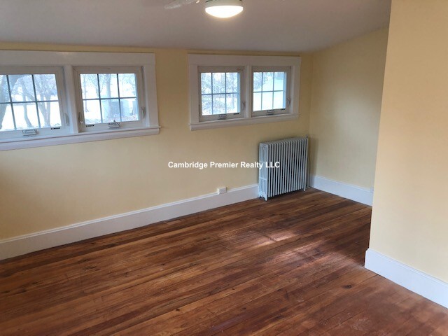
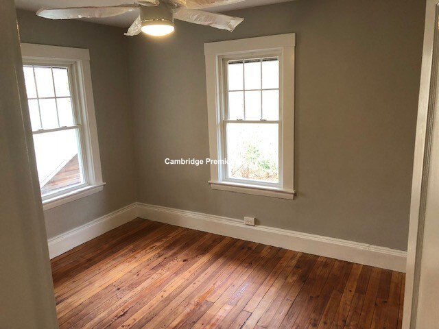
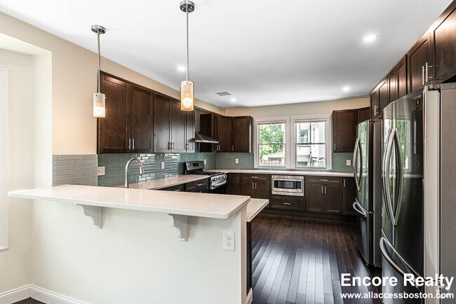
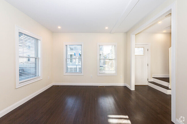
Beautiful/ Renovated 4 bed/1.5 bath single-family home in Lynnfield available NOW. -4 spacious bedrooms -1.5 bathrooms -gleaming hardwood floors -ceiling fans -huge driveway -huge yard -gas heat -dishwasher -deleaded No pets
82 Main St is a house located in Essex County and the 01940 ZIP Code.
House Features
Washer/Dryer
Dishwasher
Hardwood Floors
Fireplace
- Washer/Dryer
- Fireplace
- Dishwasher
- Hardwood Floors
- Dining Room
Fees and Policies
The fees below are based on community-supplied data and may exclude additional fees and utilities.
- Parking
-
Surface Lot--
Property Address:
82 Main St,
Lynnfield,
MA
01940
 This Property
 Available Property
The suburbs north of Boston along the I-95 corridor in Essex County constitute a mix of rolling wooded hills, housing developments, sleepy New England villages and coastal lakes and marshes. Bedroom communities such as Lynnfield, Peabody and Danvers give way to the smaller working communities of Essex and Gloucester. Tourists pass through on their way to Rockport or Willowdale State Forest. Depending on location, homes of every style and size can be found here.
Learn more about living in LynnfieldBelow are rent ranges for similar nearby apartments
Amenities
- Washer/Dryer
- Fireplace
- Dishwasher
- Hardwood Floors
- Dining Room
Education
| Colleges & Universities | Distance | ||
|---|---|---|---|
| Colleges & Universities | Distance | ||
| Drive: | 17 min | 9.0 mi | |
| Drive: | 17 min | 10.1 mi | |
| Drive: | 16 min | 11.4 mi | |
| Drive: | 21 min | 11.6 mi |
82 Main St is within 17 minutes or 10.1 miles from North Shore C.C., Danvers. It is also near North Shore C.C., Lynn Campus and Tufts Univ., Medford.
Transportation options available in Lynnfield include Oak Grove Station, located 8.7 miles from 82 Main St. 82 Main St is near General Edward Lawrence Logan International, located 15.2 miles or 26 minutes away, and Manchester Boston Regional, located 40.9 miles or 59 minutes away.
| Transit / Subway | Distance | ||
|---|---|---|---|
| Transit / Subway | Distance | ||
|
|
Drive: | 14 min | 8.7 mi |
|
|
Drive: | 16 min | 11.2 mi |
| Drive: | 16 min | 11.4 mi | |
|
|
Drive: | 20 min | 11.6 mi |
|
|
Drive: | 18 min | 12.5 mi |
| Commuter Rail | Distance | ||
|---|---|---|---|
| Commuter Rail | Distance | ||
|
|
Drive: | 5 min | 2.2 mi |
|
|
Drive: | 5 min | 2.5 mi |
|
|
Drive: | 8 min | 3.3 mi |
|
|
Drive: | 9 min | 6.0 mi |
|
|
Drive: | 11 min | 6.7 mi |
| Airports | Distance | ||
|---|---|---|---|
| Airports | Distance | ||
|
General Edward Lawrence Logan International
|
Drive: | 26 min | 15.2 mi |
|
Manchester Boston Regional
|
Drive: | 59 min | 40.9 mi |
Time and distance from 82 Main St.
| Shopping Centers | Distance | ||
|---|---|---|---|
| Shopping Centers | Distance | ||
| Drive: | 3 min | 1.3 mi | |
| Drive: | 4 min | 2.1 mi | |
| Drive: | 7 min | 2.7 mi |
82 Main St has 3 shopping centers within 2.7 miles, which is about a 7-minute drive. The miles and minutes will be for the farthest away property.
| Parks and Recreation | Distance | ||
|---|---|---|---|
| Parks and Recreation | Distance | ||
|
Breakheart Reservation
|
Drive: | 12 min | 4.0 mi |
|
Friends of Middlesex Fells Reservation
|
Drive: | 14 min | 5.6 mi |
|
Saugus Ironworks National Historic Site
|
Drive: | 12 min | 6.0 mi |
|
Walter D. Stone Memorial Zoo
|
Drive: | 11 min | 6.5 mi |
|
Middlesex Fells Reservation
|
Drive: | 11 min | 6.8 mi |
82 Main St has 5 parks within 6.8 miles, including Breakheart Reservation, Walter D. Stone Memorial Zoo, and Friends of Middlesex Fells Reservation.
| Hospitals | Distance | ||
|---|---|---|---|
| Hospitals | Distance | ||
| Drive: | 12 min | 4.9 mi | |
| Drive: | 12 min | 6.7 mi | |
| Drive: | 13 min | 8.7 mi |
82 Main St has 3 hospitals within 8.7 miles, the nearest is MelroseWakefield Healthcare which is 4.9 miles away and a 12 minutes drive.
| Military Bases | Distance | ||
|---|---|---|---|
| Military Bases | Distance | ||
| Drive: | 22 min | 11.9 mi | |
| Drive: | 28 min | 15.0 mi |
82 Main St is 11.9 miles from Fort Pickering, and is convenient to other military bases, including Fort Miller.
You May Also Like
Similar Rentals Nearby
-
-
-
-
 $6,9756 Beds, 5.5 Baths, 2,215 sq ftHouse for Rent
 -
-
 $11,0005 Beds, 4.5 Baths, 3,600 sq ftHouse for Rent
 -
-
-
-

What Are Walk Score®, Transit Score®, and Bike Score® Ratings?
Walk Score® measures the walkability of any address. Transit Score® measures access to public transit. Bike Score® measures the bikeability of any address.
What is a Sound Score Rating?
A Sound Score Rating aggregates noise caused by vehicle traffic, airplane traffic and local sources

82 Main St
Lynnfield, MA 01940