$1,400 / Month
83 High St
Milford, MA 01757
6 Days Ago
Favorites
83 High St
Favorites
Check Back Soon for Upcoming Availability
| Beds | Baths | Average SF |
|---|---|---|
| 1 Bedroom 1 Bedroom 1 Br | 1 Bath 1 Bath 1 Ba | 400 SF |
About This Property
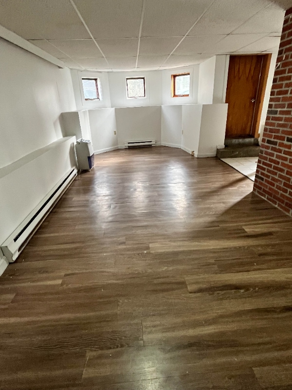
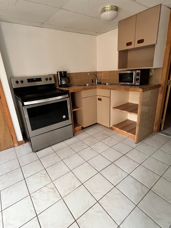
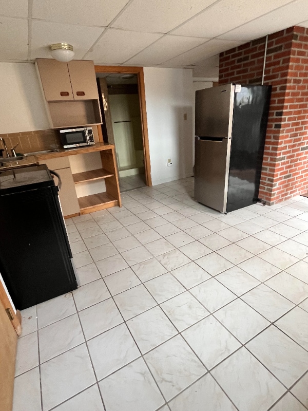
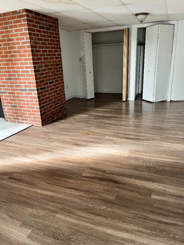
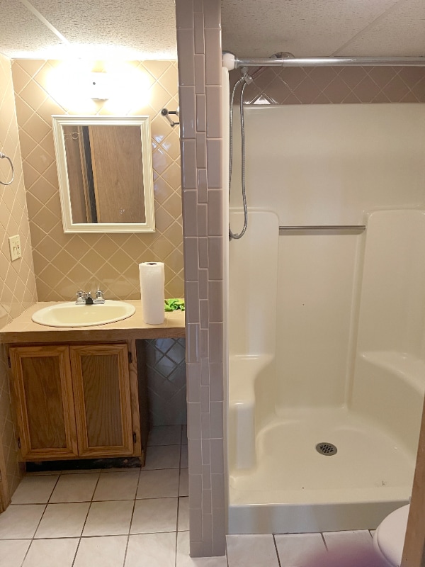
Property Id: 993612 Basement studio apartment with sink, electric stove, and refrigerator, bathroom with shower (no tub), one off-street parking spot, utilities included. Near to center of town, town library, post office, hospital. Walking distance to restaurants. Rent-to-income ratio of 30% required; first and last month's rent to move in. No pets. Renter's insurance required. Ideal for anyone happy with a small space in a nice neighborhood and convenient location.
83 High St is an apartment community located in Worcester County and the 01757 ZIP Code.
Features
- Oven
- Refrigerator
- Tile Floors
Fees and Policies
The fees below are based on community-supplied data and may exclude additional fees and utilities.
Details
Utilities Included
-
Water
-
Electricity
-
Trash Removal
-
Sewer
Property Address:
83 High St,
Milford,
MA
01757
Forty miles southwest of Boston, Milford is a thriving town nestled amid the lush forests and rocky hills of Worcester County. Most of the community is made up of residential neighborhoods, with a broad variety of apartments and condos making up the majority of the local rental market. Main Street connects the timeless Downtown district’s vintage storefronts on the southwest side to the more modern shopping centers on the east side, forming the town’s main commercial corridor. Milford Pond serves as the centerpiece of the community, with Plains Park and Clark Island providing great venues for outdoor recreation including baseball diamonds and access to the Charles River Bike Trails.
Learn more about living in Milford
Amenities
- Oven
- Refrigerator
- Tile Floors
Expenses
Utilities Included
Water, Electricity, Trash Removal, Sewer
Included
Education
| Colleges & Universities | Distance | ||
|---|---|---|---|
| Colleges & Universities | Distance | ||
| Drive: | 32 min | 15.4 mi | |
| Drive: | 37 min | 17.2 mi | |
| Drive: | 28 min | 18.2 mi | |
| Drive: | 34 min | 22.7 mi |
83 High St is within 28 minutes or 18.2 miles from Framingham State College. It is also near Tufts University, Grafton and Wellesley College.
Transportation options available in Milford include Riverside Station, located 29.3 miles from 83 High St. 83 High St is near Worcester Regional, located 27.3 miles or 47 minutes away, and Rhode Island Tf Green International, located 34.6 miles or 54 minutes away.
| Transit / Subway | Distance | ||
|---|---|---|---|
| Transit / Subway | Distance | ||
|
|
Drive: | 41 min | 29.3 mi |
|
|
Drive: | 41 min | 29.6 mi |
|
|
Drive: | 42 min | 30.3 mi |
|
|
Drive: | 44 min | 31.9 mi |
|
|
Drive: | 45 min | 32.1 mi |
| Commuter Rail | Distance | ||
|---|---|---|---|
| Commuter Rail | Distance | ||
|
|
Drive: | 14 min | 8.3 mi |
|
|
Drive: | 16 min | 9.6 mi |
|
|
Drive: | 19 min | 10.9 mi |
|
|
Drive: | 24 min | 12.3 mi |
|
|
Drive: | 25 min | 12.5 mi |
| Airports | Distance | ||
|---|---|---|---|
| Airports | Distance | ||
|
Worcester Regional
|
Drive: | 47 min | 27.3 mi |
|
Rhode Island Tf Green International
|
Drive: | 54 min | 34.6 mi |
Time and distance from 83 High St.
| Shopping Centers | Distance | ||
|---|---|---|---|
| Shopping Centers | Distance | ||
| Walk: | 18 min | 0.9 mi | |
| Drive: | 4 min | 1.8 mi | |
| Drive: | 4 min | 2.0 mi |
83 High St has 3 shopping centers within 2.0 miles, which is about a 4-minute walk. The miles and minutes will be for the farthest away property.
| Parks and Recreation | Distance | ||
|---|---|---|---|
| Parks and Recreation | Distance | ||
|
Upton State Forest
|
Drive: | 14 min | 6.9 mi |
|
Blackstone River and Canal Heritage State Park
|
Drive: | 14 min | 7.5 mi |
|
Mass Audubon's Waseeka Wildlife Sanctuary
|
Drive: | 21 min | 9.1 mi |
|
Whitehall State Park
|
Drive: | 25 min | 10.4 mi |
|
Ashland State Park
|
Drive: | 20 min | 11.2 mi |
83 High St has 5 parks within 11.2 miles, including Upton State Forest, Blackstone River and Canal Heritage State Park, and Mass Audubon's Waseeka Wildlife Sanctuary.
| Hospitals | Distance | ||
|---|---|---|---|
| Hospitals | Distance | ||
| Drive: | 3 min | 1.3 mi | |
| Drive: | 21 min | 12.6 mi |
83 High St is 1.3 miles from Milford Regional Medical Center, and is convenient to other hospitals, including Landmark Medical Center.
| Military Bases | Distance | ||
|---|---|---|---|
| Military Bases | Distance | ||
| Drive: | 33 min | 15.4 mi |
83 High St is 15.4 miles and a 33 minute drive from US Military Reservation.
You May Also Like
Similar Rentals Nearby


What Are Walk Score®, Transit Score®, and Bike Score® Ratings?
Walk Score® measures the walkability of any address. Transit Score® measures access to public transit. Bike Score® measures the bikeability of any address.
What is a Sound Score Rating?
A Sound Score Rating aggregates noise caused by vehicle traffic, airplane traffic and local sources

83 High St
Milford, MA 01757