1 / 22


| Beds | Baths | Average SF |
|---|---|---|
| 3 Bedrooms 3 Bedrooms 3 Br | 3 Baths 3 Baths 3 Ba | 2,062 SF |
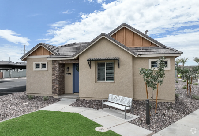
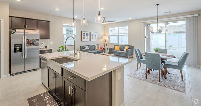
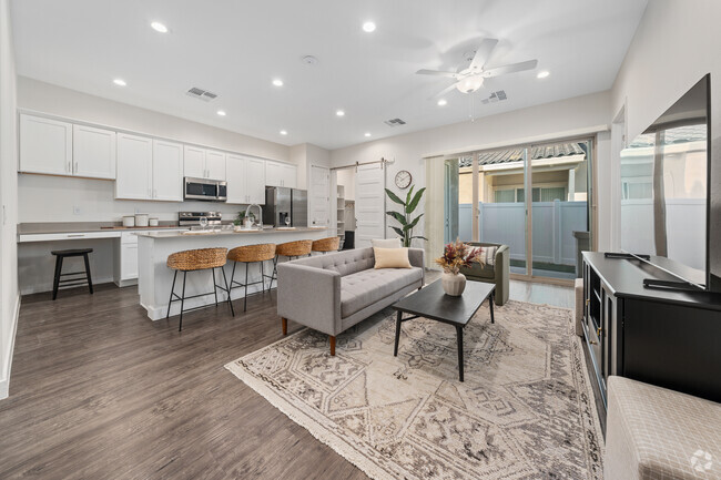
Very private home in secluded Cul-de-sac with mature trees. Two-story,3 bedrooms with a Loft,Formal Living,Formal Dining,Family Room and Kitchen with views of beautiful backyard. All new SS appliances in Kitchen with trendy white cabinets. First level has neutral tile. Second level has neutral colored carpeting. Granite counter-tops in kitchen. Low maintenance desert landscape in front,covered patio in backyard and just enough grass and mature trees to enjoy your days and evenings outside. Security System,Washer/Dryer/Fridge/Microwave,flat-top range. Walk to Desert Breeze Park or Intel. Just a few miles from Chandler Fashion Square Mall. Kyrene School District,Corona Del Sol High School.
854 N Rita Ct is a house located in Maricopa County and the 85226 ZIP Code. This area is served by the Kyrene Elementary attendance zone.
Situated about four miles west of Downtown Chandler, West Chandler is a scenic suburb brimming with recreation and retail. West Chandler residents enjoy access to an array of local parks, including Desert Breeze Park, Nozomi Park, and Hanger Park, as well as close proximity to the sprawling South Mountain Park.
Retail options in West Chandler provide a host of modern delights and everyday conveniences, with numerous shopping centers and plazas strewn throughout the area in addition to the upscale Chandler Fashion Center. West Chandler is also convenient to the popular Lone Butte Casino. Getting around from West Chandler is easy with access to the Santan Freeway, Maricopa Freeway, and the Price Freeway.
Learn more about living in West Chandler| Beds | Average Size | Lowest | Typical | Premium |
|---|---|---|---|---|
| Studio Studio Studio | 384 Sq Ft | $1,198 | $1,980 | $3,515 |
| 1 Bed 1 Bed 1 Bed | 746 Sq Ft | $1,175 | $1,892 | $4,218 |
| 2 Beds 2 Beds 2 Beds | 1073 Sq Ft | $1,303 | $2,250 | $4,935 |
| 3 Beds 3 Beds 3 Beds | 1442 Sq Ft | $1,758 | $2,978 | $9,684 |
| 4 Beds 4 Beds 4 Beds | 2667 Sq Ft | $2,599 | $4,722 | $10,500 |
| Colleges & Universities | Distance | ||
|---|---|---|---|
| Colleges & Universities | Distance | ||
| Drive: | 14 min | 8.0 mi | |
| Drive: | 17 min | 8.5 mi | |
| Drive: | 17 min | 8.5 mi | |
| Drive: | 15 min | 9.1 mi |


Transportation options available in Chandler include Rural/Apache, located 7.2 miles from 854 N Rita Ct. 854 N Rita Ct is near Phoenix Sky Harbor International, located 13.6 miles or 22 minutes away, and Phoenix-Mesa Gateway, located 18.4 miles or 27 minutes away.
| Transit / Subway | Distance | ||
|---|---|---|---|
| Transit / Subway | Distance | ||
|
|
Drive: | 14 min | 7.2 mi |
|
|
Drive: | 15 min | 7.4 mi |
|
|
Drive: | 15 min | 7.5 mi |
|
|
Drive: | 16 min | 8.1 mi |
|
|
Drive: | 15 min | 9.7 mi |
| Commuter Rail | Distance | ||
|---|---|---|---|
| Commuter Rail | Distance | ||
|
|
Drive: | 31 min | 21.4 mi |
| Airports | Distance | ||
|---|---|---|---|
| Airports | Distance | ||
|
Phoenix Sky Harbor International
|
Drive: | 22 min | 13.6 mi |
|
Phoenix-Mesa Gateway
|
Drive: | 27 min | 18.4 mi |
Time and distance from 854 N Rita Ct.
| Shopping Centers | Distance | ||
|---|---|---|---|
| Shopping Centers | Distance | ||
| Walk: | 7 min | 0.4 mi | |
| Walk: | 9 min | 0.5 mi | |
| Walk: | 12 min | 0.6 mi |
| Parks and Recreation | Distance | ||
|---|---|---|---|
| Parks and Recreation | Distance | ||
|
Pecos Park
|
Drive: | 10 min | 4.9 mi |
|
South Mountain Park
|
Drive: | 15 min | 6.8 mi |
|
ASU Center for Meteorite Studies
|
Drive: | 16 min | 7.7 mi |
|
Desert Arboretum Park
|
Drive: | 17 min | 8.2 mi |
|
i.d.e.a. Museum
|
Drive: | 19 min | 11.8 mi |
| Hospitals | Distance | ||
|---|---|---|---|
| Hospitals | Distance | ||
| Drive: | 6 min | 3.2 mi | |
| Drive: | 8 min | 4.1 mi | |
| Drive: | 9 min | 4.3 mi |
| Military Bases | Distance | ||
|---|---|---|---|
| Military Bases | Distance | ||
| Drive: | 21 min | 14.4 mi | |
| Drive: | 51 min | 38.9 mi | |
| Drive: | 100 min | 80.2 mi |
What Are Walk Score®, Transit Score®, and Bike Score® Ratings?
Walk Score® measures the walkability of any address. Transit Score® measures access to public transit. Bike Score® measures the bikeability of any address.
What is a Sound Score Rating?
A Sound Score Rating aggregates noise caused by vehicle traffic, airplane traffic and local sources

854 N Rita Ct
Chandler, AZ 85226