88 Peterborough St
88 Peterborough St,
Boston,
MA
02215
2 Weeks Ago
Favorites
88 Peterborough St

Favorites
Check Back Soon for Upcoming Availability
About 88 Peterborough St Boston, MA 02215
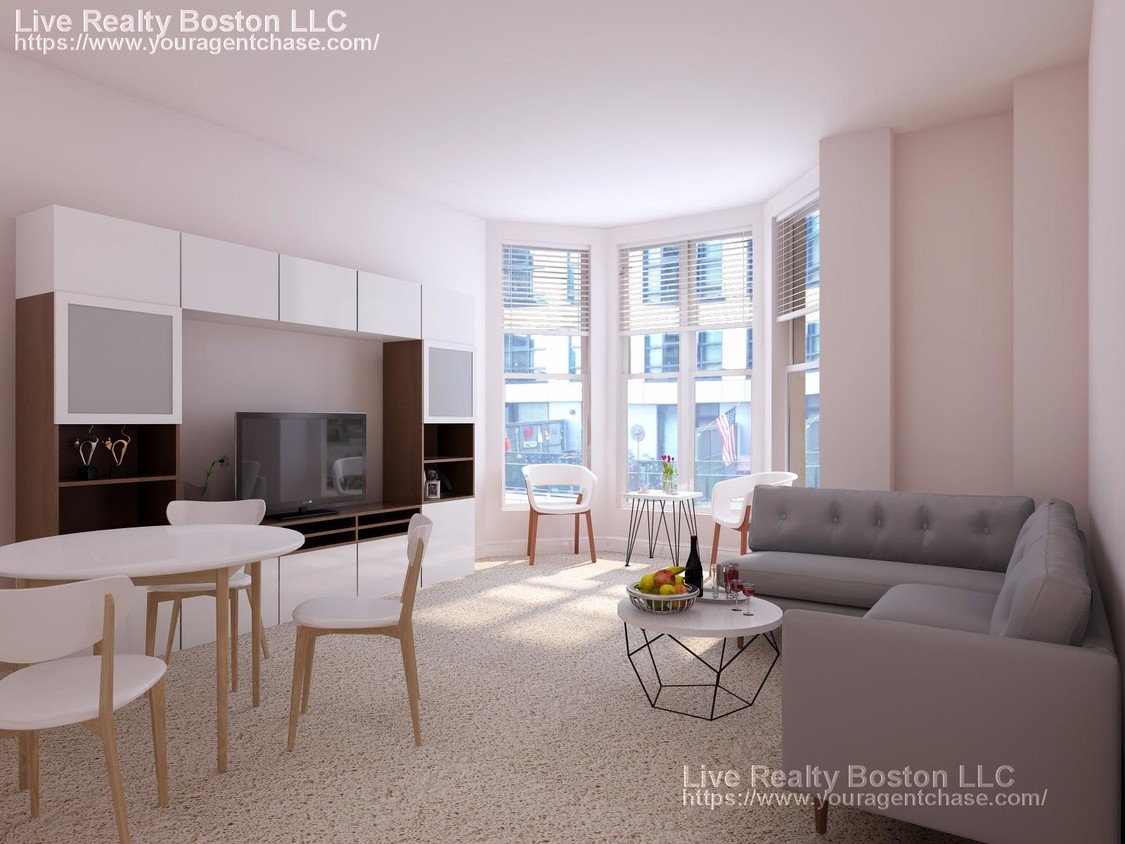
AWESOME 3 BED GEM~ Fenway, commonly referred to as The Fenway, is a mostly one-way, one- to three-lane parkway that runs along the southern and eastern edges of the Back Bay Fens in the Fenway–Kenmore neighborhood of Boston, in the east-central part of the U.S. state of Massachusetts. As part of the Emerald Necklace park system mainly designed by Frederick Law Olmsted in the late 19th century, the Fenway, along with the Back Bay Fens and Park Drive, connects the Commonwealth Avenue Mall to the Riverway. For its entire length, the parkway travels along the Muddy River and is part of the Metropolitan Park System of Greater Boston. Like others in the park system, it is maintained by the Massachusetts Department of Conservation and Recreation.
88 Peterborough St is an apartment community located in Suffolk County and the 02215 ZIP Code.
Location
Get Directions
Tree-filled, historic, and packed with educational opportunity, there's no other neighborhood quite like Fenway. The neighborhood may be most well-known for its titular attraction, Fenway Park, home of the Boston Red Sox. However, the area is also renowned for its sprawling greenspace. The name "Fenway" refers to the neighborhood’s lush parkway and tree-filled paths that wind lazily through the area, forming part of Frederick Law Olmsted’s “Emerald Necklace Plan” (a chain of parks throughout Boston). The Fenway opened in 1876, and its route includes the Museum of Fine Arts and the Isabella Steward Gardner Museum.
Learn more about living in FenwayBelow are rent ranges for similar nearby apartments
| Beds | Average Size | Lowest | Typical | Premium |
|---|---|---|---|---|
| Studio Studio Studio | 2061-2062 Sq Ft | $1,600 | $2,577 | $7,650 |
| 1 Bed 1 Bed 1 Bed | 2461-2463 Sq Ft | $1,900 | $3,360 | $11,520 |
| 2 Beds 2 Beds 2 Beds | 2956-2958 Sq Ft | $2,350 | $4,115 | $29,270 |
| 3 Beds 3 Beds 3 Beds | 3421-3422 Sq Ft | $1,395 | $5,187 | $25,000 |
| 4 Beds 4 Beds 4 Beds | 5661-5663 Sq Ft | $1,500 | $7,228 | $20,490 |
Education
| Colleges & Universities | Distance | ||
|---|---|---|---|
| Colleges & Universities | Distance | ||
| Walk: | 9 min | 0.5 mi | |
| Walk: | 9 min | 0.5 mi | |
| Walk: | 11 min | 0.6 mi | |
| Drive: | 2 min | 1.1 mi |
88 Peterborough St is within 9 minutes or 0.5 mile from Simmons College. It is also near Emmanuel College and Lesley Univ., Art Institute.
Transportation options available in Boston include Fenway Station, located 0.4 mile from 88 Peterborough St. 88 Peterborough St is near General Edward Lawrence Logan International, located 6.3 miles or 14 minutes away.
| Transit / Subway | Distance | ||
|---|---|---|---|
| Transit / Subway | Distance | ||
|
|
Walk: | 8 min | 0.4 mi |
|
|
Walk: | 10 min | 0.5 mi |
|
|
Walk: | 12 min | 0.6 mi |
|
|
Walk: | 12 min | 0.6 mi |
|
|
Drive: | 3 min | 1.4 mi |
| Commuter Rail | Distance | ||
|---|---|---|---|
| Commuter Rail | Distance | ||
|
|
Drive: | 3 min | 1.5 mi |
|
|
Drive: | 7 min | 1.8 mi |
| Drive: | 6 min | 2.6 mi | |
|
|
Drive: | 7 min | 3.2 mi |
|
|
Drive: | 7 min | 4.1 mi |
| Airports | Distance | ||
|---|---|---|---|
| Airports | Distance | ||
|
General Edward Lawrence Logan International
|
Drive: | 14 min | 6.3 mi |
Time and distance from 88 Peterborough St.
| Shopping Centers | Distance | ||
|---|---|---|---|
| Shopping Centers | Distance | ||
| Walk: | 8 min | 0.4 mi | |
| Walk: | 12 min | 0.6 mi | |
| Drive: | 9 min | 5.1 mi |
88 Peterborough St has 3 shopping centers within 5.1 miles, which is about a 9-minute walk. The miles and minutes will be for the farthest away property.
| Parks and Recreation | Distance | ||
|---|---|---|---|
| Parks and Recreation | Distance | ||
|
Charles River Reservation
|
Drive: | 3 min | 1.3 mi |
|
Coit Observatory
|
Drive: | 3 min | 1.4 mi |
|
John Fitzgerald Kennedy National Historic Site
|
Drive: | 4 min | 1.8 mi |
|
Boston Public Garden
|
Drive: | 6 min | 2.1 mi |
|
Roxbury Heritage State Park
|
Drive: | 5 min | 2.2 mi |
88 Peterborough St has 5 parks within 2.2 miles, including Charles River Reservation, Coit Observatory, and Roxbury Heritage State Park.
| Hospitals | Distance | ||
|---|---|---|---|
| Hospitals | Distance | ||
| Walk: | 9 min | 0.5 mi | |
| Walk: | 13 min | 0.7 mi | |
| Drive: | 2 min | 1.1 mi |
88 Peterborough St has 3 hospitals within 1.1 miles, the nearest is Beth Israel Deaconess Medical Center which is 0.5 mile away and a 9 minute walk.
| Military Bases | Distance | ||
|---|---|---|---|
| Military Bases | Distance | ||
| Drive: | 28 min | 14.7 mi | |
| Drive: | 27 min | 15.6 mi |
88 Peterborough St is 14.7 miles from Hanscom Air Force Base, and is convenient to other military bases, including US Military Reservation.
You May Also Like
Similar Rentals Nearby


What Are Walk Score®, Transit Score®, and Bike Score® Ratings?
Walk Score® measures the walkability of any address. Transit Score® measures access to public transit. Bike Score® measures the bikeability of any address.
What is a Sound Score Rating?
A Sound Score Rating aggregates noise caused by vehicle traffic, airplane traffic and local sources